This article was originally published in Slovak: Prečo Slovensko vôbec existuje?
Slovakia has 5.4 million people, its own language, an anthem, the euro and a seat at the UN. It looks like a given. But if we look at a map of Europe from 1900, we find nothing called Slovakia. We won’t find it on a map from 1500 or 1000 either. It was not a kingdom, a principality or a province. It had no borders, no capital and no nobility that would claim it as its own.
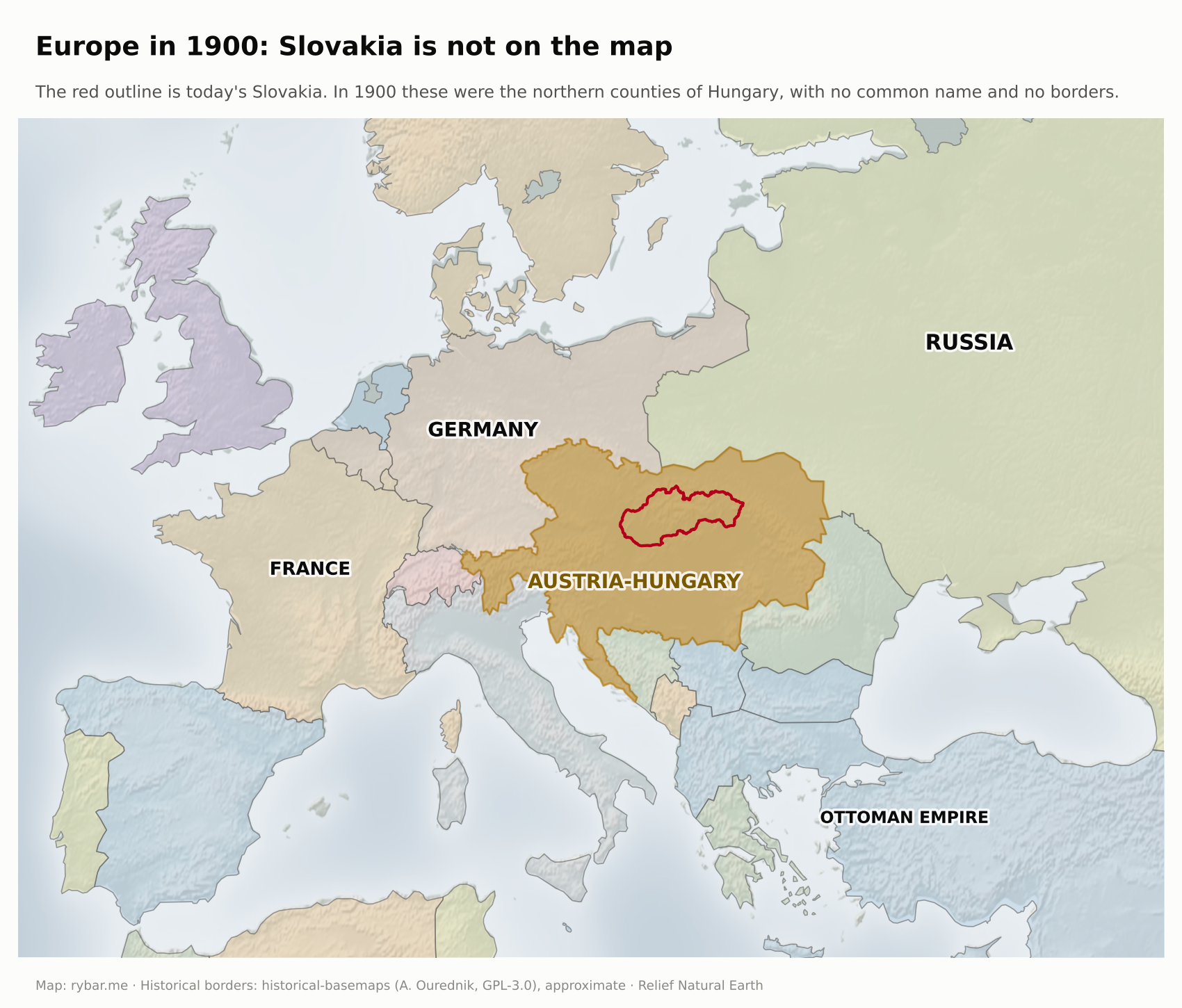
In the first two parts we asked why Slovakia is so long and thin and why Bratislava is on the edge. What remains is the question that perhaps should have come first:
- Why can’t we find Slovakia even on the map drawn by nature?
- Where did the Slavs come from, and why are there so many of them?
- Why didn’t the people below the Tatras become Hungarians, even though they lived in the Hungarian kingdom for 900 years?
- Why didn’t they become Czechs, even though they wrote in Czech for 400 years and still understand Czech today?
- Why aren’t they called Moravians, Poles or Rusyns?
- What is a nation, anyway, and how long has the Slovak one existed?
- Why did a state come into being whose independence nobody voted for?
- Why do people confuse Slovakia with Slovenia?
- Why do Slovaks keep talking about a bridge between East and West?
We’ll start with what was here before people: mountains and rivers.
A country nature didn’t draw
Let’s erase all state borders from the map of Europe and keep only the relief. Some countries remain visible anyway, because the natural unit and today’s state almost coincide. The Iberian Peninsula beyond the Pyrenees with Spain and Portugal. The Apennine Peninsula beyond the Alps with Italy. The British Isles with the United Kingdom and Ireland. The Scandinavian Peninsula with Norway and Sweden, the Jutland Peninsula with Denmark. France between the Pyrenees, the Alps, the Rhine and two seas. Greece in the mountainous south of the Balkan Peninsula. And two large bowls in the middle of the continent.
The first is the Bohemian Basin. Mountains line it on all sides, the Bohemian Forest, the Ore Mountains, the Giant Mountains and the Bohemian-Moravian Highlands, and the Elbe carries its water to the North Sea. For centuries the Czech state stayed roughly within the edges of this bowl.
The second is the Pannonian Basin, which we wrote about in the first part. The Alps, the Carpathians and the Dinaric Alps surround it, and the Danube collects all its water. It, too, had its own state for a thousand years: Hungary.

Let’s now try to find Slovakia the same way. We’ll look at it from four angles.
Relief. Slovakia is not a bowl. It is the northern rim of someone else’s bowl: mountains in the north, an open plain in the south. Standing on the Danubian Lowland or the East Slovak Lowland, you see no obstacle in the direction of Hungary.
River basins. About 96% of the territory drains through the Danube into the Black Sea. The Váh, Nitra, Hron, Ipeľ, Slaná, Hornád and Bodrog all flow south, out of the country. Only the Poprad and the Dunajec flow north to the Baltic. No river connects west and east. Slovakia has no basin of its own; it is the upper part of someone else’s.
Valleys. Between the mountain ranges lies a row of basins, Turiec, Liptov, Zvolen, Košice and others. Each is a small world that opens to the south. Together they don’t form a whole; they form a comb with partitions.
Natural borders. In the north the border is clear: the Carpathian ridge, which also carries the main European watershed between the Baltic and the Black Sea. In the west it is half clear: the Morava River and the White Carpathians. In the south and east there is none. The plain continues, and the border we see there today was drawn only between 1918 and 1920, both by soldiers and at the negotiating table.
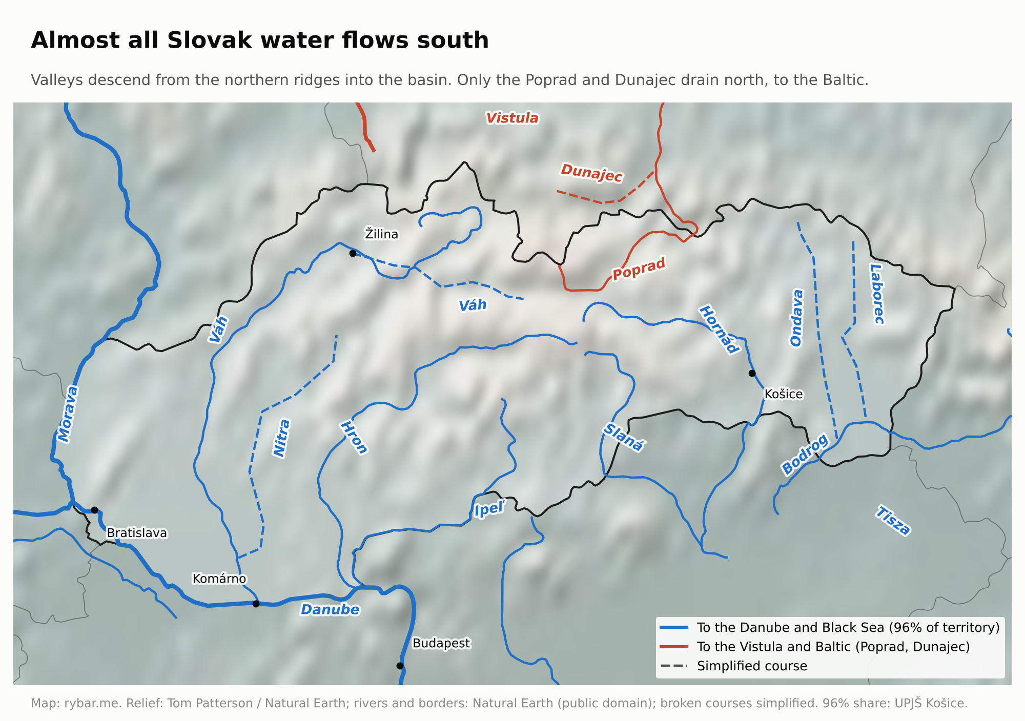
Two things follow from this, and we’ll keep coming back to them. First, Slovakia is not a natural unit but part of a larger one, so its history is the history of the basin. Second, the Czech lands and Slovakia belong to two different natural units. Bohemia drains into the North Sea, Slovakia into the Black Sea. Between them lies Moravia, whose river also flows into the Danube, but which is separated from Slovakia by the start of the Carpathian arc. When Czechoslovakia is founded in 1918, it will be a political project in spite of geography, not thanks to it.
So if nature didn’t draw Slovakia, people must have. Their story begins far to the east, in the forest-steppe between the Dniester and the Don.
Where the Slavs came from
As late as the 5th century, Germanic tribes lived in the lowlands of today’s Slovakia. Around the turn of the 6th century the Slavs arrived, and over the following centuries their language spread across much of Central and Eastern Europe and the Balkans.
In the 6th century the Byzantine historian Procopius and the Gothic historian Jordanes wrote about them. They knew them as the Sclaveni, the Antes and the Veneti. Historians and archaeologists argued for a long time about where they came from. One school held that people moved. The other held that it was rather a language and a way of life that spread, and the locals simply adopted it.
In September 2025, the journal Nature published a study that largely settled the dispute. An international team analyzed the DNA of 555 people from 26 sites in Central and Eastern Europe. The result: between the 6th and 8th centuries, men and women from Eastern Europe arrived and replaced more than 80% of the original gene pool in eastern Germany, Poland and Croatia. The authors place the origin of this population between the Dniester and the Don, that is, in today’s Ukraine and southern Belarus.
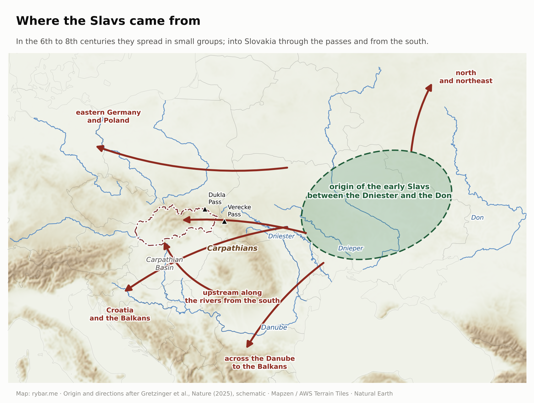
The study also describes how it happened. It was not a single expedition but a mosaic of movements by smaller groups. The early Slavs lived in small settlements with sunken huts, cremated their dead, used simple handmade pottery and had little metal.
Just as important is what happened a little farther south. Slavs also settled in today’s Hungary, even before the Avars arrived. Local place names still give it away: Balaton comes from the Slavic word for mud, Visegrád means “upper castle,” Nógrád “new castle,” and the name Pest is explained from the Slavic word for an oven or a cave. From 568 the Avars, nomads from the steppe, ruled the basin. When their power collapsed around 800, Slavic principalities emerged on both sides of the Danube, one of them by Lake Balaton. Only the arrival of the Hungarians a hundred years later turned the center of the basin into a Hungarian land and made the Slavs in the mountains on its northern edge a separate group.
The Slavs came to the territory of Slovakia by two routes: through the Carpathian passes from the north and east, and upstream along the rivers from the south and southeast. This double route matters. Linguists use it to explain why Central Slovak shares some features with the South Slavic languages. We’ll come back to that.
A large family and its smaller members
About 300 million people speak Slavic languages today. There are thirteen Slavic states: Russia, Ukraine, Belarus, Poland, Czechia, Slovakia, Slovenia, Croatia, Bosnia and Herzegovina, Serbia, Montenegro, North Macedonia and Bulgaria.
Slovaks are among the smaller ones. Slovakia has about 5.4 million people. Russia has 144 million, Poland about 37 million and Czechia over 10 million. Smaller are, for example, Slovenia with two million or North Macedonia with just under two. Among the West Slavs with a state of their own, Slovaks are the smallest. Even smaller are the Slavic nations without a state: the Sorbs in Germany, numbering about 60,000, the Kashubians in Poland, or the Rusyns.
By area the picture is similar. Russia has 17.1 million km², Ukraine 604,000, Poland 313,000. Slovakia, with 49,000 km², is just behind Bosnia and Herzegovina with 51,000. North Macedonia has just under 26,000. All of Slovakia would fit into Russia about 350 times. Russia, however, skews the numbers. Three quarters of its territory lie beyond the Urals in Asia and are sparsely populated; the European part up to the Urals has about 110 million people on just under 4 million km². And not all its inhabitants are Slavs: in the 2021 census, 72% of people gave Russian as their ethnicity and 11% gave none. The same applies to the other states, but most of all to Russia.

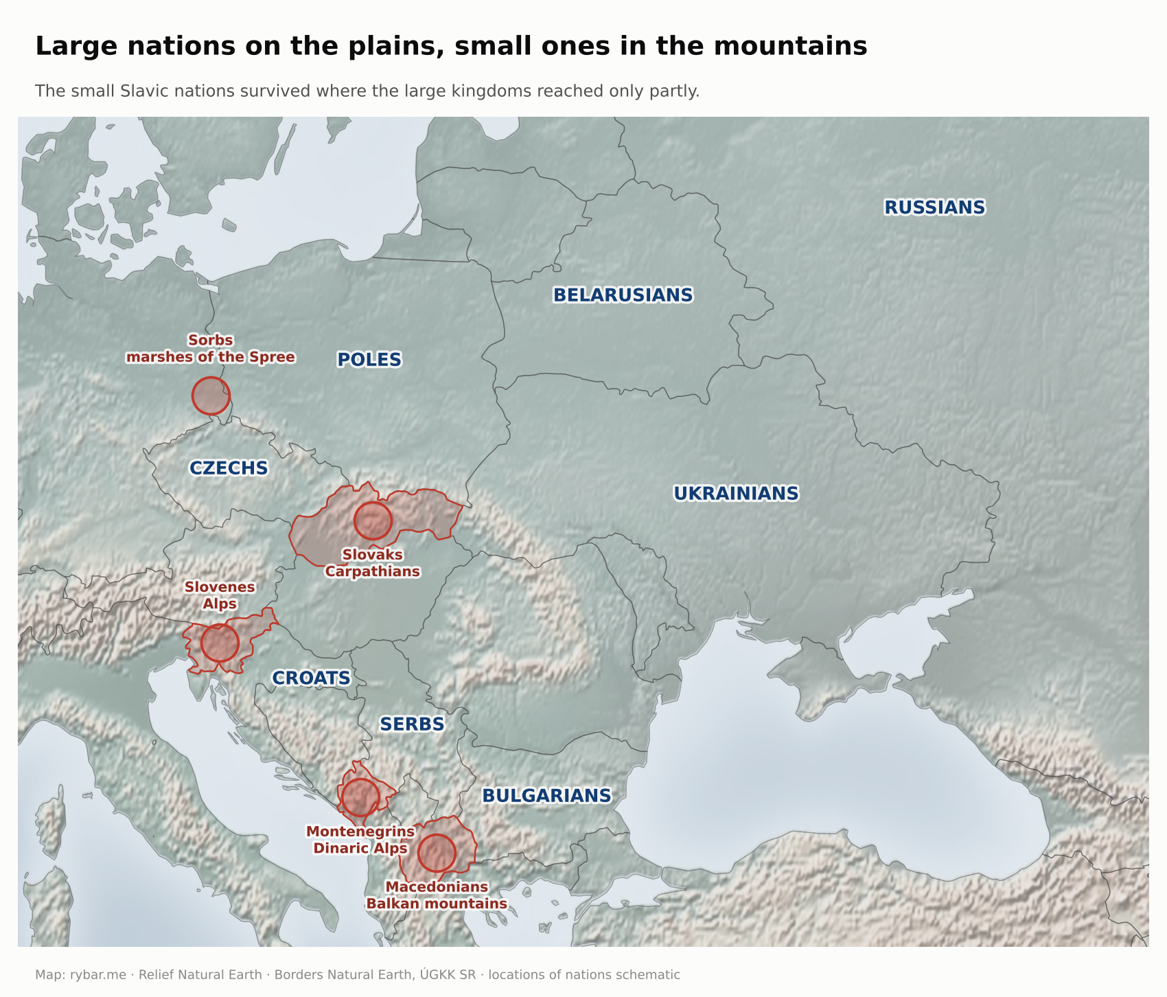
Notice where the smaller ones live. Slovenes in the Alps, Montenegrins and Macedonians in the Balkan mountains, Slovaks in the Carpathians, Sorbs in the marshes of the Spree. The large Slavic nations formed on plains, where a large kingdom could be built. The small ones survived where large kingdoms reached only partly. The mountains did not let them grow, but they did not let them disappear either.
Between the Franks and Constantinople
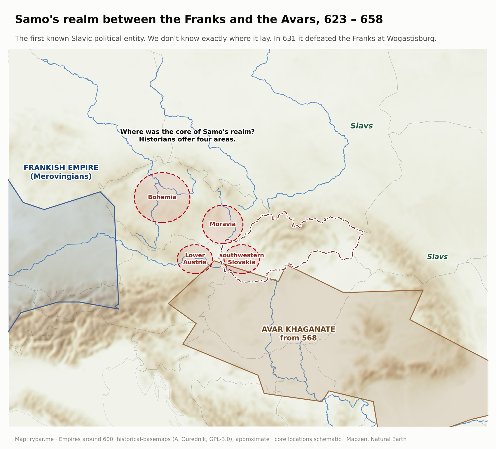
For their first two centuries on the middle Danube, the Slavs lived in the shadow of the Avars. Against them arose Samo’s tribal union (623 to 658), the first known Slavic political entity. We wrote about the battle of Wogastisburg, where Samo defeated the Franks in 631, in the article about Bratislava. We don’t know exactly where it lay; historians place it in Moravia, Bohemia, southwestern Slovakia or Lower Austria. The real turning point came when Charlemagne crushed the Avars at the end of the 8th century. A power vacuum was left in their place, and two Slavic principalities stepped into it on both sides of the Morava.
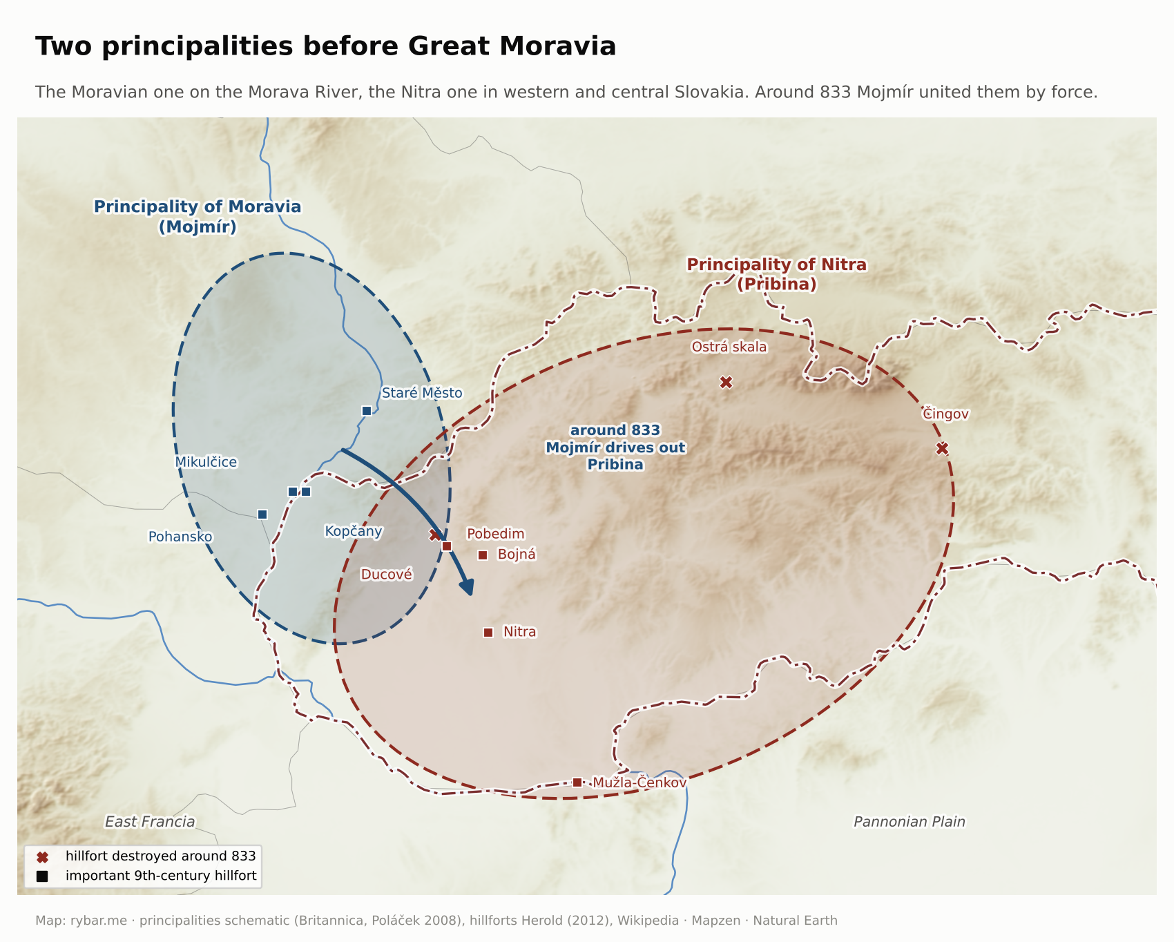
Pribina ruled in Nitra. Around 828 the Archbishop of Salzburg consecrated a church for him, the first known Christian church among the West and East Slavs. Around 833 the Moravian prince Mojmír drove him out and united the two principalities. A century later, the Byzantine emperor Constantine Porphyrogenitus called the state that emerged Great Moravia.
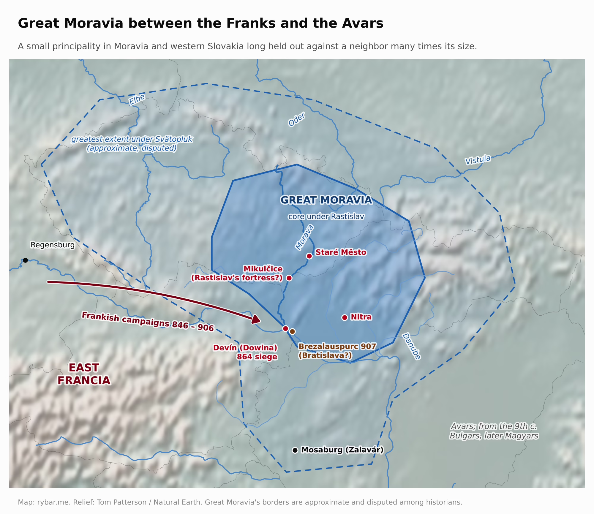
Its location was both advantageous and dangerous. To the west lay East Francia, the strongest state in Europe at the time, which considered Moravia its borderland and its princes its vassals. Bavarian priests from Passau and Salzburg brought Christianity here, and Frankish influence came with them. Whoever controlled the church controlled the scribes, diplomacy and legitimacy.
Prince Rastislav understood this. Around 861 he asked the pope for a bishop of his own, and when he failed, he turned in 862 to the other end of the Christian world, the Byzantine emperor Michael III. In 863 two brothers from Thessaloniki, Constantine and Methodius, came from Constantinople. They spoke Slavic, because the area around Thessaloniki was Slavic. Constantine created a script for the Slavic language, Glagolitic, and translated the Gospels and the liturgy into it.
It was a bold step. In the Western church, services were held in Latin; in the East, in Greek. The Slavic liturgy meant that Slavic became Europe’s fourth liturgical language, after Hebrew, Greek and Latin. Pope Adrian II approved it in 868 and soon afterward named Methodius archbishop. On his way back, Bavarian bishops captured him and held him prisoner for three years. He was released only after Pope John VIII intervened.
In 880 that pope issued the charter Industriae tuae. In it he confirmed the Slavic liturgy, took Svätopluk and his people under the protection of the Holy See and established a bishopric in Nitra. Great Moravia thus ceased to be a Frankish borderland and became a state recognized by Rome. Yet in the same charter, Wiching, a Swabian monk and Methodius’s opponent, became Bishop of Nitra.
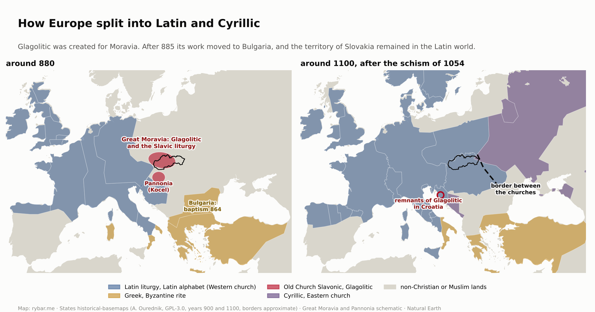
After Methodius died in 885, Pope Stephen V banned the Slavic liturgy, and Svätopluk had Methodius’s disciples expelled. They went to Bulgaria, and the work created for Moravia took root there. In Preslav and Ohrid it grew into Cyrillic and a literature later adopted by the Serbs and Russians. The legacy of the brothers from Thessaloniki thus lives on today mainly among the Orthodox Slavs. In Slovakia, what remained was Latin Christianity, a few words and a tradition the nation returned to only a thousand years later.
The expulsion of Methodius’s disciples has a consequence that is still visible on the map. The territory of Slovakia became part of the Western, Latin civilization. A hundred years later the Hungarians also accepted Christianity from Rome, and King Stephen received his crown from the pope. When the Western and Eastern churches finally split in 1054, the dividing line ran along the eastern Carpathians. On one side fell the Latin alphabet, Gothic cathedrals, town law, universities and later the Reformation. On the other, Cyrillic, icons and Orthodoxy. Had Methodius prevailed over Wiching in Moravia, people in Nitra might write in Cyrillic today, as they do in Sofia or Belgrade.
The border between the two worlds still runs through eastern Slovakia. The Greek Catholics, who since the Union of Uzhhorod in 1646 have combined the Eastern rite with obedience to Rome, are its living reminder.
Svätopluk expanded the realm to its greatest extent; it included Bohemia, Pannonia, the land of the Vistulans and part of the Tisza region. After his death in 894, his sons quarreled. In 895 and 896 the Hungarians, a nomadic confederation from the eastern steppes, crossed the Carpathians and occupied the lowland. Around 906 Great Moravia ceased to exist, and in 907 the Hungarians defeated the Bavarian army near Bratislava.
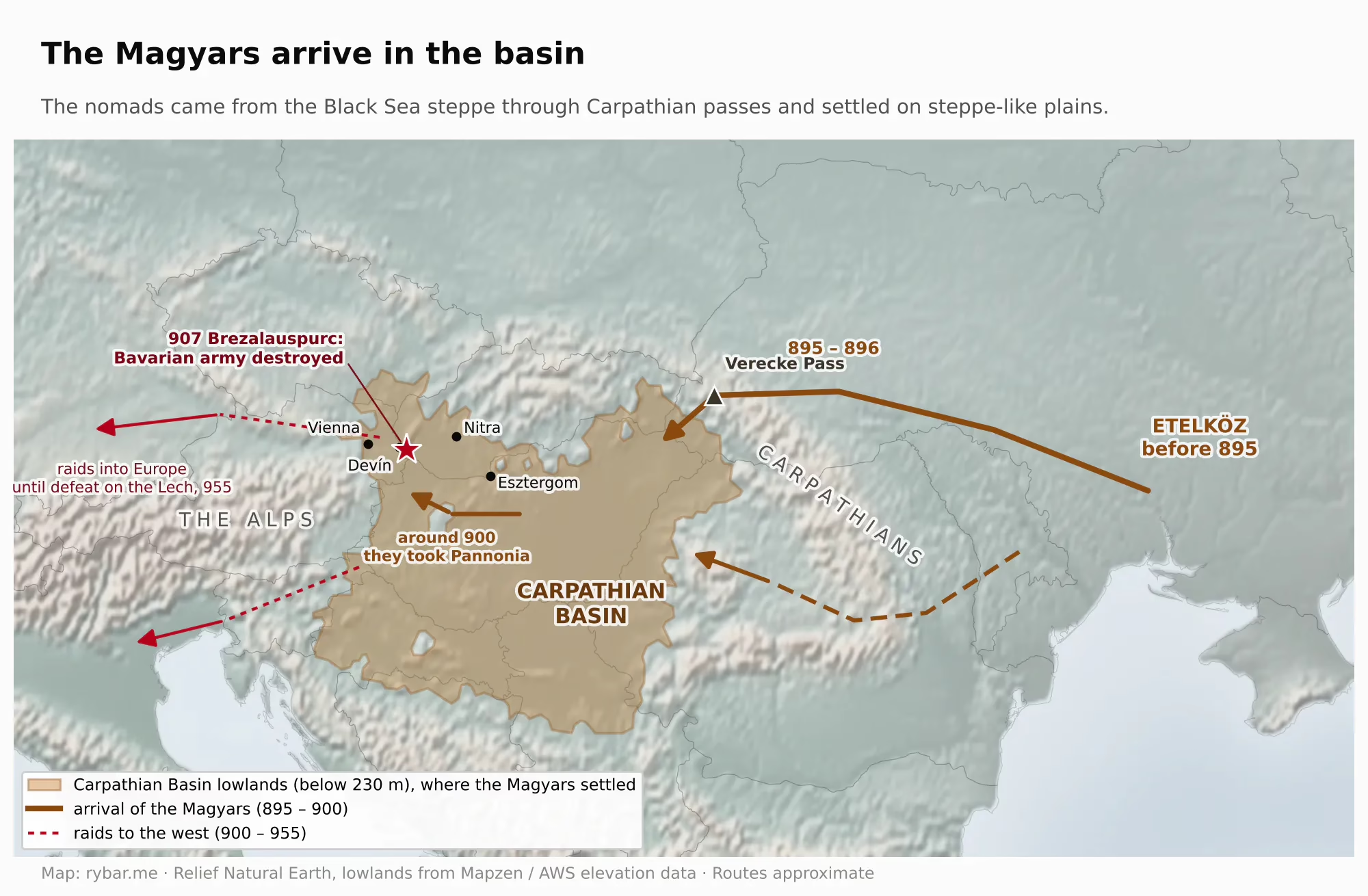
On the map it looks as if the Hungarians followed in the footsteps of the Slavs: they, too, came from the eastern steppes, and they, too, came through the Carpathian passes. But there is no causal link between the two movements. More than three hundred years separate them, and the Hungarians were pushed out of Etelköz, the steppes north of the Black Sea, around 895 by the Pechenegs allied with the Bulgarians. What they share is geography, not cause; that is our interpretation. Anyone coming from the steppes could enter the basin only through a few gates in the Carpathians or along the Danube, and the Verecke Pass was one of them.
What does this mean for our question? Great Moravia was not a Slovak state, and its inhabitants were not called Slovaks. Its core lay in today’s Moravia. But it showed two things that will repeat. First: the land on the edge of the basin is where Western and Eastern influences meet, and whoever rules here has to maneuver between them. Second: the arrival of the Hungarians split the Slavs, who until then had formed a single belt. Those west of the Morava River became part of the Czech state. Those east of it became part of the Hungarian one. The border on the Morava River and the ridge of the White Carpathians lasted a thousand years and is the oldest reason why Slovaks are not Moravians.
Slav and slave
The Slavs called themselves Slověne. Linguists most often derive the name from the word “slovo,” meaning “word”: the Slavs were those who speak intelligibly, unlike the Germans, the “Nemci,” or “mute ones,” whom no one could understand. The origin of the name, however, is disputed.
The Greeks adapted the name to Sklabenoi, which gave the Latin Sclavus. In the 9th and 10th centuries this word began to be used in Western Europe with a different meaning. On its eastern border the Frankish Empire waged constant wars with pagan Slavs and sold the captives. Enslaving a Christian was not allowed; enslaving a pagan was. The trade in slaves from Slavic lands was described in 961 to 962 by the merchant Ibrahim ibn Yaqub, who visited Prague, and later Venice and Genoa also grew rich on it. The Arabs called these slaves Saqaliba.

There were so many of them that the name of the people replaced the old Latin word servus. Hence the English slave, German Sklave, French esclave, Spanish esclavo and Italian schiavo. And from the Venetian greeting s-ciavo, “I am your slave,” came ciao, which half the world uses as a greeting today, Slovaks included.
This affected Slovaks directly too. In Hungarian Latin documents they were called Sclavi. When scholars in the early modern period realized how the word sounded to foreigners, they began signing themselves Slavi or invented learned substitutes like Pannoni. A nation that later grew up around the idea that language is its most precious possession thus bears a name that means both “people of the word” and “slaves.”
A century between two states
What happened on the territory of Slovakia between 907, when Great Moravia ceased to exist, and 1000, when the Kingdom of Hungary was founded? Written sources are almost silent. Here is what we know.
The people stayed. Archaeologists trace continuous settlement in the Nitra region from the 9th to the 13th century. According to historians, the Hungarians managed to take control of western Slovakia only in the second half of the 10th century.
Nitra did not disappear either. In the 11th century it was the seat of a duchy within the Kingdom of Hungary. The last duke was Álmos, and his rule ended in 1108.
Around the turn of the millennium the northern neighbor also reached into this territory. According to Gallus Anonymus and the Hungarian-Polish Chronicle, the Polish ruler Bolesław the Brave seized Hungarian territory all the way to the Danube. According to historian Ján Steinhübel, this may have happened only after 1002. Hungary regained it in 1018 according to some, or only in 1030 according to others.
Why couldn’t the Poles hold on here? The sources don’t say; our interpretation is geographic. From the north, you enter Slovakia across the main Carpathian ridge through passes that were under snow for half the year, and the valleys behind them lead away from Poland. From the south, the same valleys are open gates. Whoever held the lowland held the mouths of all the valleys at once, and with them the roads, salt and grain. The edge of the basin belongs to whoever rules the basin.
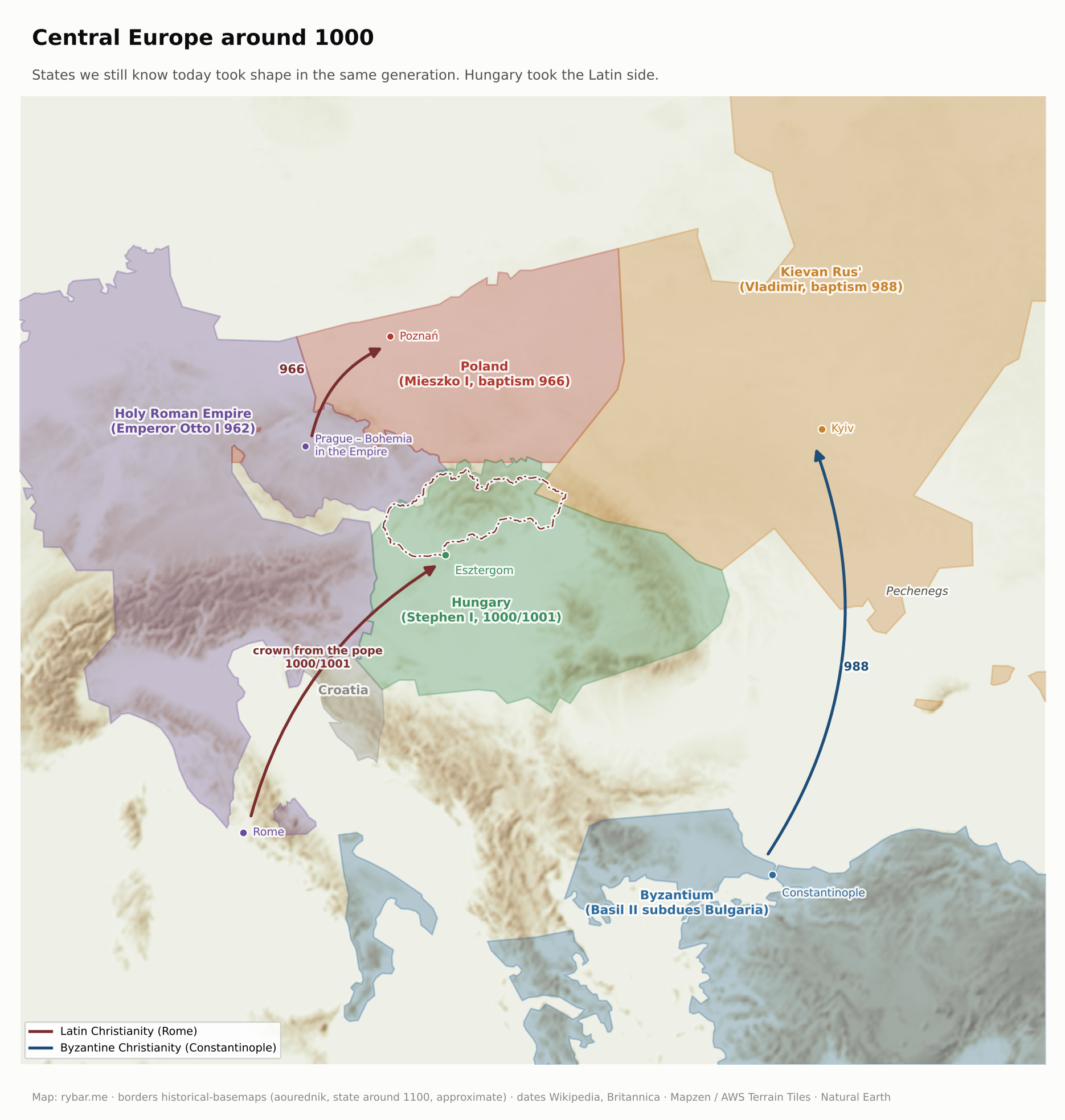
Let’s look west and east as well. Around the turn of the millennium, states we still know today were taking shape around the basin at the same time. In the west, Otto I had himself crowned emperor in Rome in 962, and the Holy Roman Empire, which included Bohemia, became the strongest power in Central Europe. In the north, Mieszko I accepted baptism in 966, and with it Latin Christianity. In the east, Prince Vladimir of Kyiv was baptized from Constantinople in 988. In the south, the Byzantine emperor Basil II gradually subdued Bulgaria. Hungary in the middle chose the West: Stephen I was crowned on December 25, 1000, or January 1, 1001, with a crown sent by Pope Sylvester II. The territory of Slovakia thus ended up inside a state that took the Latin side in this contest.
Nine hundred years in Hungary
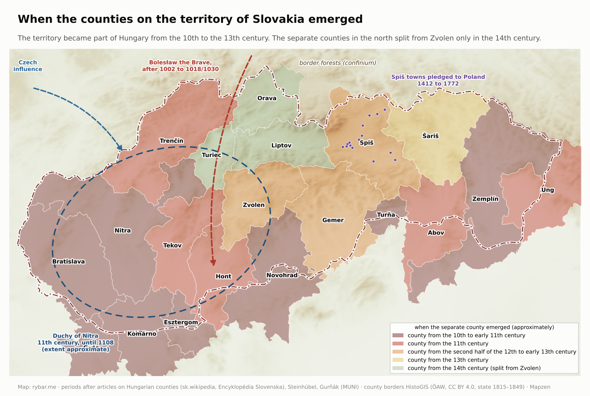
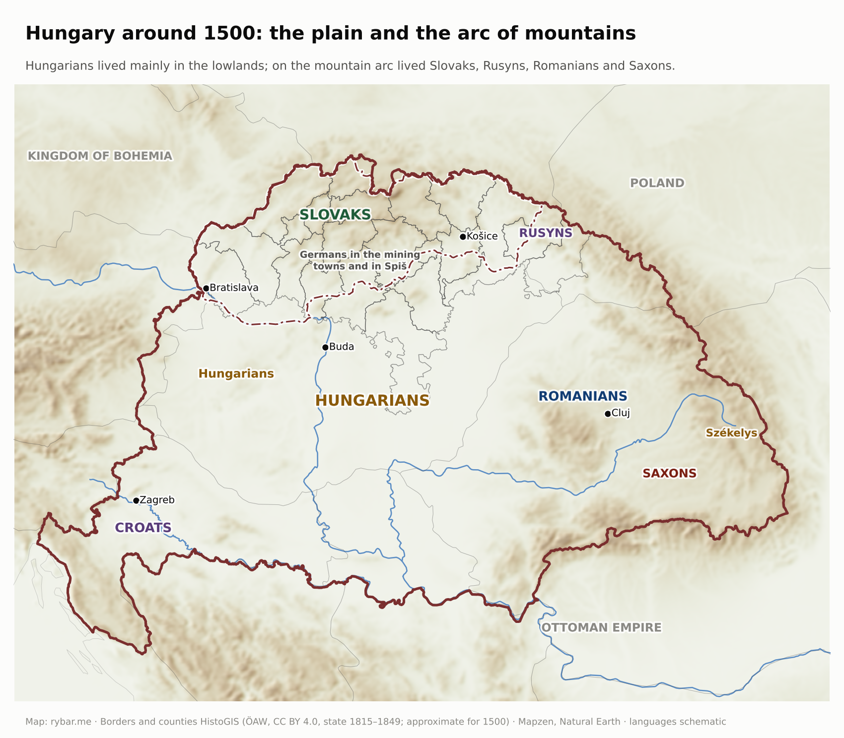
The Hungarians occupied the plain because, as herders, they needed grass. At first the mountains didn’t interest them. The Slavs in the northern valleys stayed where they were and were gradually incorporated into the Kingdom of Hungary, founded by Stephen I in 1000, from south to north, from the 10th to the 13th century. The separate counties in the north, Orava, Liptov and Turiec, split off from Zvolen only in the 14th century. Hungarian borrowed hundreds of words from the Slavs for things the nomads didn’t know: farming, crafts, the state and the church. Király is “kráľ” (king); megye, meaning county, comes from the Slavic word medja, a boundary or border strip; ispán is “župan” (count of a county); kovács is “kováč” (smith), kasza “kosa” (scythe), asztal “stôl” (table); and szerda, csütörtök and péntek are “streda,” “štvrtok” and “piatok,” Wednesday, Thursday and Friday.
Even afterward, the north kept one oddity. On March 15, 1412, King Sigismund pledged sixteen Spiš towns to the King of Poland as collateral for a loan of 37,000 threescore of Prague groschen. The pledge lasted 360 years, until 1772. The towns remained part of Hungary, but the Polish kings collected their revenues. Note the south on the map as well: the counties there reached deep into the lowland, and the 1920 border cut through many of them. We’ll come back to that with the war over the southern border.
Why did the Slavic language survive in the mountains even though it had no state, no schools and no writing? We covered this in detail in the first part. In brief:
- The valleys were cut off from one another, and royal power reached them only through castles and counties. The village lived its own life.
- Hungary was not a Hungarian state in today’s sense. Its official language until 1844 was Latin. The king didn’t care what language a subject spoke as long as he paid taxes.
- The political nation, the natio hungarica, was the nobility, regardless of language. A squire from Turiec or Liptov spoke Slovak at home and Latin in the county, and considered himself Hungarian.
- After the Mongol invasion of 1241, the kings invited colonists: Germans to the towns and mines, later Vlachs to the mountain pastures. From the 14th century the Roma also appear in the country. The land was so diverse that no language could swallow the others.
Latin documents called these people Sclavi, the Hungarians Tót, the Germans Winden or Slowaken. The land where they lived was called Upper Hungary or simply “the upper lands.” The word Slovensko, Slovakia, was later used only for the area where Slovaks lived, not for a territory with borders.
The most Slovak of all remained three small counties beyond the ridges of the Fatra: Orava, Turiec and Liptov. They lie in enclosed basins that you can reach from the lowland only through the narrow valleys of the Váh, Turiec and Orava, and they lasted as separate counties from the 14th century until the old counties were abolished at the end of 1922. They had their own minor nobility, squires who spoke Slovak at home. It was from here that the national movement later emerged: in Martin in Turiec, the Memorandum of the Slovak Nation was adopted in 1861, Matica slovenská was founded there in 1863, and the Martin Declaration followed in 1918. Our interpretation is geographic: the language, and with it the seed of the nation, survived best where the plain was farthest away.
Two kingdoms
While the Slovaks lived as a nameless people in someone else’s kingdom, their closest relatives had their own. Bohemia was a principality from the 9th century and a hereditary kingdom from the early 13th century. The King of Bohemia was one of the seven prince-electors who chose the Holy Roman Emperor, and Charles IV himself became emperor in 1355. Prague had a university from 1348. The Czechs had a nobility, towns, laws and chronicles in their own language.
Why did a Czech kingdom emerge and not a Slovak one? A geographic explanation suggests itself. Bohemia is a basin enclosed by mountains, and its princes unified it before anyone else could swallow it. Within the Holy Roman Empire they kept their own ruler, won the royal title in 1198, and the Golden Bull of Sicily confirmed it as hereditary in 1212. The territory of Slovakia has no such wall in the south. Its valleys open onto the lowland the Hungarians came from, and the Duchy of Nitra, the only seed of self-rule, ended in 1108. By the time Bohemia was becoming a kingdom, the territory of Slovakia was already being gradually absorbed into Hungary.
This is the most important difference between the two nations, and it explains much of what follows. When the Czechs begin demanding their rights in the 19th century, they will speak of restoring a historical state. The Slovaks will have nothing to restore.
Nor was the Czech kingdom unchanging. Besides Bohemia and Moravia, the Lands of the Bohemian Crown included Silesia, Upper and Lower Lusatia and the County of Kladsko. Ferdinand II ceded both Lusatias to Saxony in the Peace of Prague in 1635. Maria Theresa lost most of Silesia, together with Kladsko, to Prussia in 1742. Today’s Czechia is what was left of the crown: Bohemia, Moravia and a small piece of Silesia around Opava and Těšín.

The Hussites and Jiskra: the first foreign army they understood
From 1419 to 1436 the Hussite Wars shook Central Europe. It was Europe’s first reformation, a hundred years before Luther, and Czech became the language of the Bible and of worship in it. The Hungarian king Sigismund of Luxembourg also claimed the Bohemian crown and led crusades against the Hussites. The Hussites took the war back to him and carried it onto the territory of Slovakia as well.
They came from Moravia through the passes of the White Carpathians and along the Váh valley, the same routes later used by every army from the west. In 1428 they reached Bratislava. In April 1430 they defeated the Hungarian army near Trnava, and in 1431 they took Nitra and, on September 29, Likava Castle in Liptov, their first permanent garrison in Hungary. In November 1431 the Hungarian army defeated them at Rudé pole near Ilava. From 1432 the Hussites built a network of garrisons in Skalica, Lednica, Topoľčany and Trnava, which they took on the night of June 24, 1432, disguised as merchants, and held until 1435.
After the Hussites came mercenaries. From 1440, John Jiskra of Brandýs controlled central and eastern Slovakia in the name of the infant king Ladislaus the Posthumous, from Zvolen and Kremnica to Košice, Levoča and Kežmarok, and in 1451 he defeated John Hunyadi near Lučenec. After him came the “bratríci,” who fortified themselves in camps, for example at Posádka near Gajary in Záhorie. Their era ended with a defeat at Veľké Kostoľany in 1467.
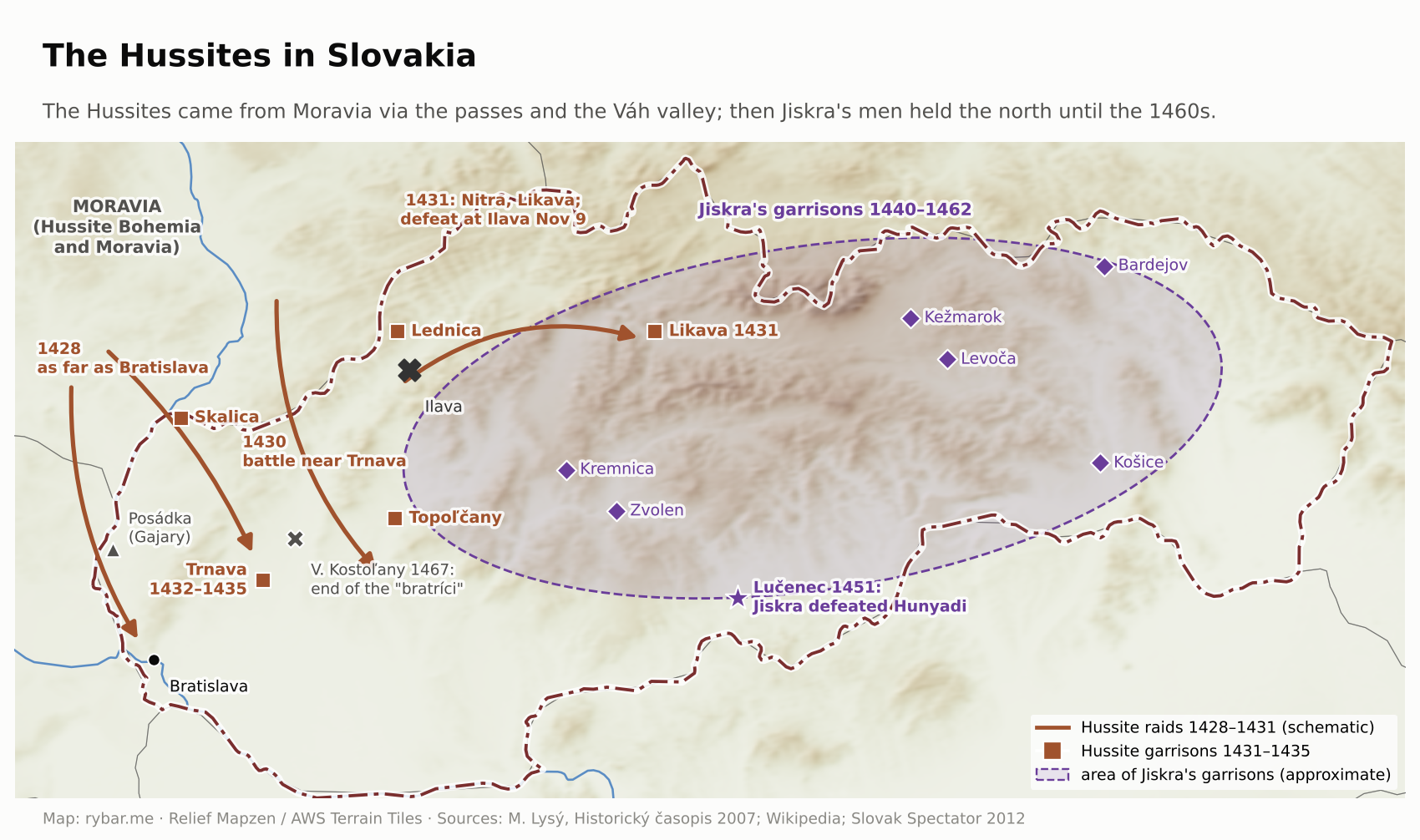
This map is the first to show clearly how the geography of the north works. Whoever came from the west through Moravia quickly got into the valleys of the Váh and the Nitra, but could hold on only where they had castles and towns. For the Slovaks these decades had one lasting consequence: with the Hussites and Jiskra’s mercenaries came Czech, a language they understood, and it became their first written language. We’ll come back to that with the Reformation.
Mohács: one ruler, two kingdoms
In 1526 Louis Jagiellon, King of both Bohemia and Hungary, fell fighting the Turks at Mohács. Both kingdoms elected the same man as his successor, Ferdinand of Habsburg. From that year until 1918, that is, for 392 years, Czechs and Slovaks shared a ruler in Vienna. But they still lived in two different kingdoms with different laws, diets, taxes and histories.

Those histories diverged above all in the 17th century. The Bohemian estates rebelled in 1618 and lost at White Mountain in 1620. In 1621, 27 leaders of the uprising were executed, and much of the Czech nobility had its property confiscated. After White Mountain, some Czech scholars left for Slovakia. The Protestant hymnal Cithara sanctorum also dates from that period.
The Hungarian estates fared differently. From Bocskai’s uprising in 1604 to the surrender of Rákóczi’s rebels at Szatmár in 1711, they repeatedly rose against the Habsburgs, mostly in alliance with the Ottoman Empire. Unlike the Bohemian estates, they were not broken by a single lost battle, and that is why Protestants survived in Hungary.
Mountains as walls
The mountains were not just an obstacle for rivers and roads. They were also a wall. Wars passed through Slovakia, but the mountains slowed them down, made them more expensive and pushed them into valleys and passes. This is clearest in the centuries when Hungary found itself on the border with the Ottoman Empire.
After Mohács the Ottoman Empire occupied the center of the kingdom. The Habsburgs were left with only a narrow strip of Hungary in the west and north, the mountainous rim of the basin. Bratislava became the capital, Trnava the seat of the archbishop. As we wrote in the article about Bratislava, ten kings and one queen were crowned there between 1563 and 1830. A town on the edge became the center precisely because the rest of the country was lost. The nobility, the offices and the church moved to a territory where most people spoke Slovak.
The Turks took the edge of the lowland and its fortresses: Fiľakovo from 1554 to 1593, when it was the seat of a sanjak, and Nové Zámky from 1663 to 1685, when they made it the center of its own eyalet. The plain in front of the mountains was a borderland and a battlefield for more than a century. Turkish raiders also plundered the valleys farther north, the Váh valley up to Piešťany and the Nitra valley up to Bojnice, but they never settled there permanently. The rich central Slovak mining towns, Banská Štiavnica, Kremnica and Banská Bystrica, were never taken by the Turks, though they tried. Banská Štiavnica built two castles because of them.
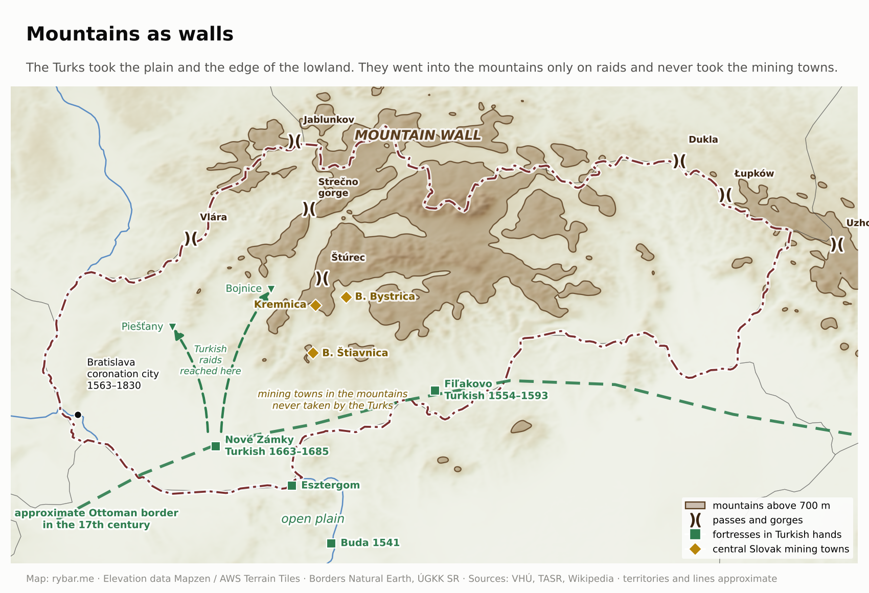
This period had three consequences that later proved important. The wars decimated the Hungarian population of the lowland, and after the Turks were driven out it was colonized by Germans, Serbs, Romanians and also Slovaks. By estimates, Hungarians made up just under 40% of the kingdom’s population around 1780; some estimates are even lower. The second consequence: the north became the most populous and most educated part of the country. And the third: the Reformation came to Upper Hungary, and with it a dispute that divided Slovaks for two centuries.
Slovaks were not only victims in these wars; they also fought in them as soldiers. The best known is Ladislav Škultéty-Gabriš from Mojtín, called the oldest hussar. He joined the hussars in 1750 at the age of twelve, served for 81 years under four monarchs and went through 22 campaigns and 256 battlefields. In 1757 he was wounded during the occupation of Berlin, when Andreas Hadik’s hussars extracted a ransom of more than 200,000 thalers from the city. He died in 1831 in Arad. When his remains were moved to Mojtín in 2013, the Hungarian government protested: Hungarians regard him as the oldest Hungarian hussar. The dispute shows that the history of Hungary is also Slovak history.
The Reformation: why Slovakia is Catholic and Czechia isn’t
The first written language of the Slovaks was Czech. It arrived in the 15th century with the Hussite armies and with Jiskra’s mercenaries, who from 1440 controlled much of Upper Hungary. It was an intelligible, ready-made literary language. In the Žilina town book from 1378 to 1561, the local language appears alongside German and Latin.
The Reformation began in Wittenberg in 1517. From Saxony it spread along trade routes and among people who understood German. Ulrich Zwingli established it in Zurich in 1522 and 1523, Sweden adopted Lutheranism in 1527, Denmark in 1536 and, with it, Norway from 1537. John Calvin worked in Geneva from 1536, and permanently from 1541, and from there his teaching spread further. Lutheranism thus went north along trade and language ties, and just as it went north, it also went east, to towns with German burghers.
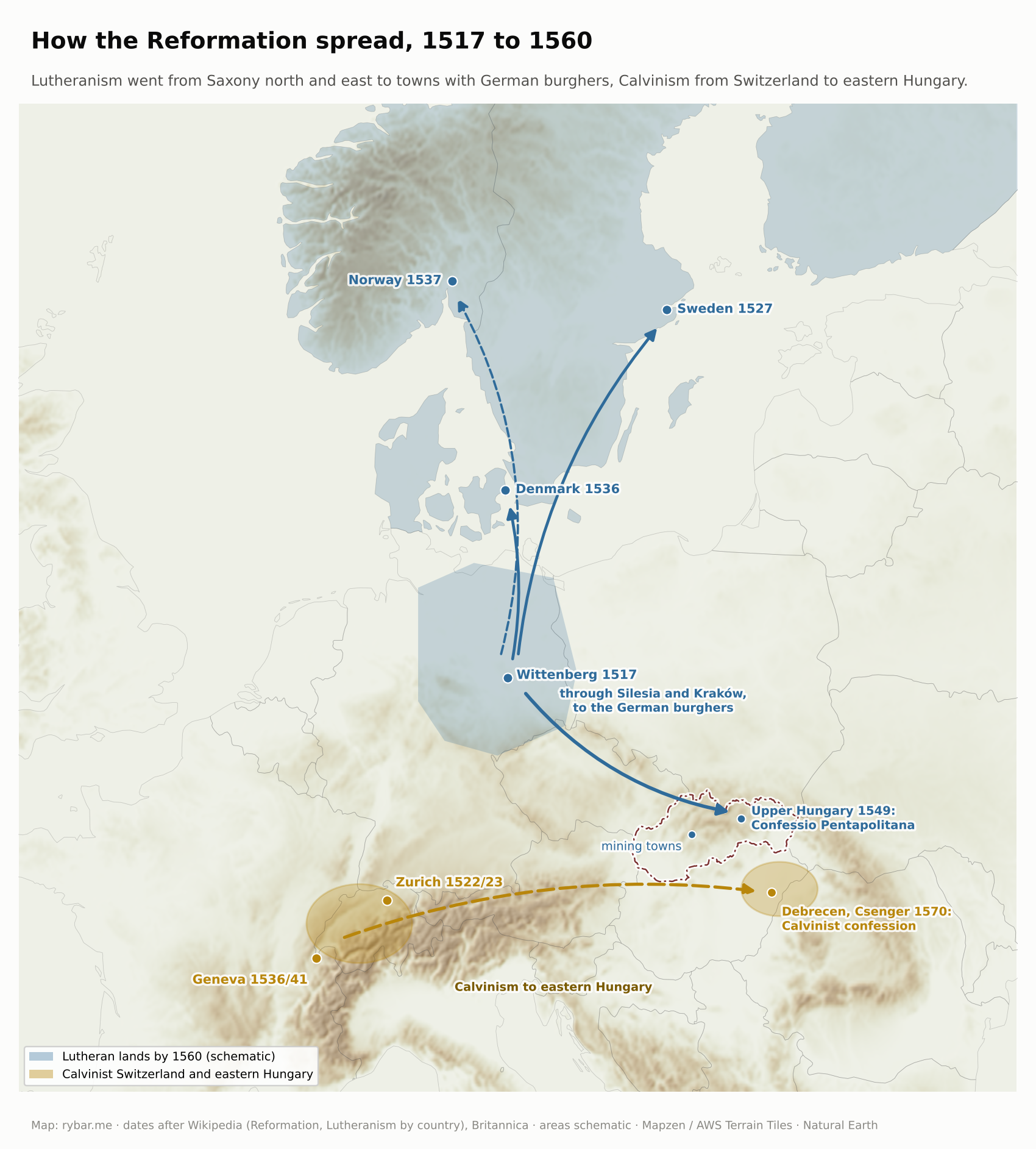
In the 16th century the Reformation also spread in Upper Hungary. It followed routes set by settlement. It was brought by the German burghers of the mining and Spiš towns; the Hungarian nobility at first rejected it as a German import, and the diet passed laws against Lutherans in 1523 and 1525. In 1549 five eastern Slovak towns, Košice, Prešov, Levoča, Bardejov and Sabinov, presented their own confession of faith, the Confessio Pentapolitana, followed by a confession of the seven central Slovak mining towns. The Calvinist Reformation was centered in the east of the lowland: the Reformed synod met in Csenger, and its confession was published in Debrecen in 1570. Slovak Lutherans adopted the Czech of the Kralice Bible, the so-called Bible Czech, as their language of worship and kept it for three hundred years. The Catholic Counter-Reformation was centered at the Jesuit university in Trnava, founded in 1635.

Elevation on the map is worth noticing too. The Lutheran towns were in the mountains and basins: the mining towns of central Slovakia and the towns of Spiš and Šariš with their German burghers. Trnava, from which the Counter-Reformation was led, lies on the plain. Calvinism was adopted mainly by Hungarian squires and peasants on the lowlands of the south and east, and the Reformed Christian Church in Slovakia is still centered in the south today. So in the mountains there were German Lutherans and Slovak Lutherans, on the plain Hungarian Calvinists, and between them a Catholic majority.
In Hungary the Counter-Reformation ran into resistance from the estates. In Article 26, the 1681 diet in Sopron allowed Lutherans one church in each free royal town and two in each county. They had to stand outside the town walls, on a site chosen by a royal commission, and be built of wood. Five of these articular churches have survived, and three of them, in Kežmarok, Hronsek and Leštiny, are on the UNESCO list. The Lutheran minority thus survived, and the Patent of Toleration issued by Joseph II on October 13, 1781, granted it freedom of worship.
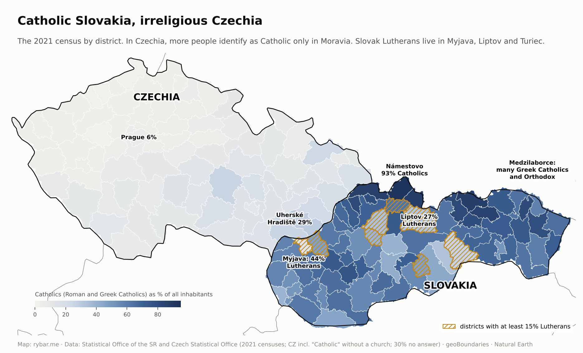
This balance had a peculiar consequence for the Slovak nation. Lutherans were only a small part of the Slovaks, about 12% of Slovakia’s population in 1930, yet they were one of the two main sources of the national movement. Kollár, Hurban and Michal Miloslav Hodža were Lutheran pastors, and Štúr was a Lutheran too. Štefánik also came from the Lutheran parsonage in Košariská and studied at the Lutheran lyceums in Bratislava, Sopron and Szarvas. The Catholic majority produced the priests Bernolák and Hollý, and later Hlinka and Tiso. Through the Bible, the Lutherans looked to Prague; the Catholics looked to Rome and Vienna. This line will appear in Slovak politics many more times. And it fits the map too: the towns in the mountains and the basins beyond the ridges were Lutheran, especially Turiec and Liptov, which later produced much of the national movement, while the center of the Catholic revival, Trnava, lies on the plain.
For the Czechs it went the other way. Protestantism disappeared after White Mountain, and the Catholic Church remained tied to the Habsburgs and German. The Czech national story of the 19th century therefore leaned on Hus and the Hussites, against Rome. On November 3, 1918, a few days after the republic was founded, a crowd in Prague tore down the Marian column on Old Town Square, which it saw as a symbol of the Habsburg monarchy. Under the slogan “Away from Rome,” about 1.4 million people then left the Catholic Church, and in 1920 the Czechoslovak Church was founded, claiming the Hussite tradition. In Slovakia, by contrast, the Catholic priest was the one who spoke to people in their language, and often the one who defended it.
The result is visible to this day. In the 2021 census, 55.8% of Slovakia’s population declared themselves Roman Catholic, 5.3% Lutheran, 4% Greek Catholic, and 23.8% had no religion. In Czechia, about 7% declared themselves Roman Catholic and 30% did not answer the question. Two countries that were one state for 74 years sit at opposite ends of Europe when it comes to religion.
In the 18th century, Slovak scholars thus wrote in three ways: Lutherans in Czech, Catholics in a Slovakized Czech, and all of them in Latin. The polymath Matej Bel described himself in words that capture the whole era: a Slav by language, a Hungarian by nation, a German by education. No one saw a contradiction in that. The contradiction came only with an idea born elsewhere.
The Spring of Nations
The next chapters belong to one story: how the idea of the modern nation was born in Europe, why in Hungary it turned into a dispute over language, and how in 1848 it grew into a revolution known as the Spring of Nations.
What a modern nation is
Without this chapter, the question in the title makes no sense. Had you asked a peasant from Orava in 1700 who he was, he would have said he was a Catholic, a subject of the Orava estate, from such and such a village. He might have added that he was a Slovak, but he would have meant the language he spoke, not a community one fights for or that owns a state. The state belonged to the king, and the “nation” was the nobility.
The nation in today’s sense, a community of all people of the same language and culture that has the right to run its own affairs, is an invention of the late 18th century. It had two sources.
The first was the French Revolution. In 1789 it declared that sovereignty belonged not to the king but to the nation, that is, to all citizens. Those citizens, however, were not yet united. According to a survey by the Abbé Grégoire in 1794, only about 3 million of 28 million people spoke French well. It took schools, the army, railroads and roads in the late 19th and early 20th centuries to turn Bretons, Occitans and Alsatians into Frenchmen.
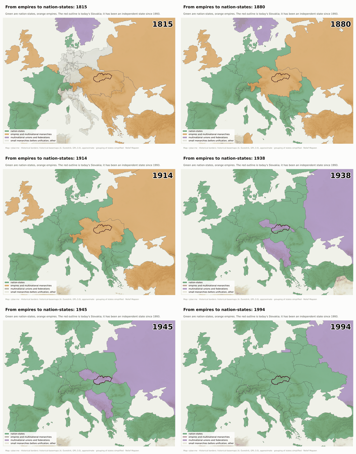
The second source was the German philosopher Johann Gottfried Herder. He argued that every nation has its own spirit, which shows itself in its language and folk songs. Whoever loses his language loses himself. In 1791 he devoted a chapter of his main work to the Slavs. He described them as a peaceful people awaiting a better future. For the scholars of small nations without a state this was a revelation: we have no king and no nobility, but we have a language, and that is enough.
Why did this idea catch on precisely then? The British-Czech philosopher and anthropologist Ernest Gellner explains it with industry. A peasant needs to know only what his father knew, and it doesn’t matter what dialect he speaks. A factory, an office and an army need people who can read and write and understand one another. Only a school in one standard language can provide that, and only a state can provide the school. Those who have schools in their own language get ahead. Those who don’t stay at the bottom or assimilate. For the first time in history, language became a political matter.
Benedict Anderson called the nation an “imagined community.” We will never meet most of its members, and yet we feel we belong with them. Newspapers and books made this possible: thousands of people read the same text in the same language on the same day and began to imagine the other readers as “us.”
And the Czech historian Miroslav Hroch described how this happened among small nations without a state. Everywhere it went through three phases. In phase A, a handful of scholars collect songs and write grammars and histories. In phase B, a new generation agitates, founds newspapers and associations and persuades the others that they are a nation. In phase C, it becomes a mass movement with political parties.
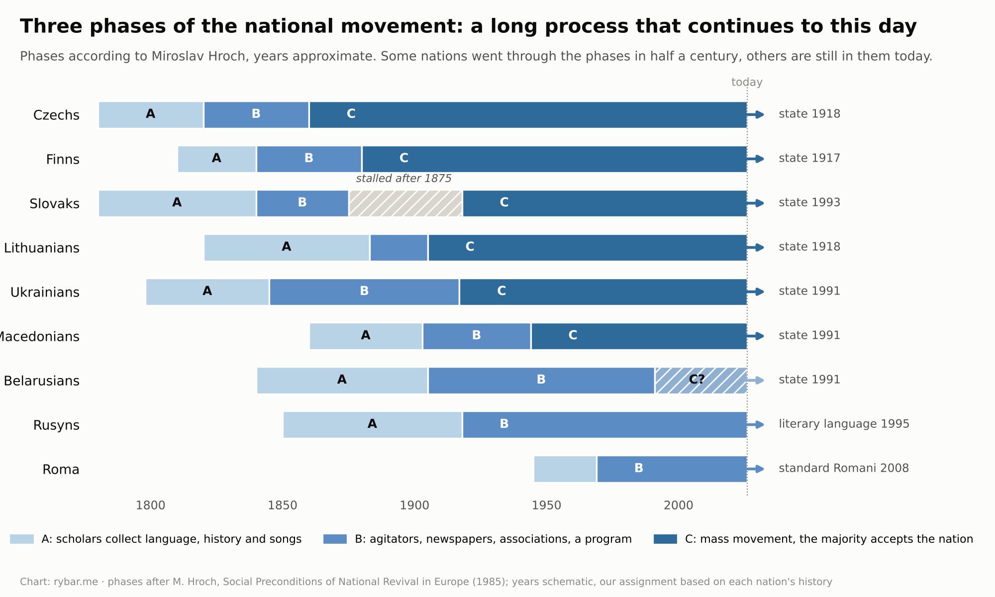
The Slovaks went through phase A at the same time as the Czechs, the Slovenes or the Finns, between 1780 and 1830. Phase B began in the 1840s. Then the process stalled for half a century, and phase C came only after 1918. Why is the heart of this story.
And the process never ended everywhere at once. The Belarusians and the Rusyns are still in it, and in Slovakia the closest example is the Roma minority. The Roma have lived on the territory of Slovakia since at least the 14th century; the first mention of them is from Spiš in 1322. They adopted their own flag and anthem at the first World Romani Congress in London in 1971; Slovakia recognized them as a national minority in 1991 and codified standard Romani in 2008. In the 2021 census, 67,179 people gave Roma as their first ethnicity and another 88,985 as their second, yet according to the 2019 Atlas of Roma Communities more than 400,000 Roma live in Slovakia. The gap between these numbers shows what Hroch describes: claiming a nation is a decision that many people have not yet made.
The trigger: when the Hungarians wanted a nation too
The idea of the nation came to Hungary from above. In 1784 Joseph II ordered German to replace Latin in the administration. The Hungarian nobility rebelled and chose Hungarian as its defense. From 1790 the diet passed one language law after another, and in 1844 Hungarian became the country’s only official language.
But Hungarians were a minority in the kingdom. If Hungary was to become a modern nation-state on the French model, the others had to become Hungarians too. For Hungarian liberals this was not oppression but progress: they offered everyone entry into a free political nation; all it took was adopting its language.
That ended the old world in which a person could be a Slav by language and a Hungarian by nation. Slovak scholars had to choose. Many chose the Hungarian nation, among them the poet Sándor Petőfi, whose father was named Petrovič and whose mother was a Hrúzová, and the leader of the revolution, Lajos Kossuth, whose uncle was a Slovak patriot. Others chose the opposite: Ján Kollár, Ľudovít Štúr, Jozef Miloslav Hurban and Michal Miloslav Hodža decided that they were Slavs and Slovaks, not Hungarians.
Why not Czechs, Poles or Rusyns
Once Slovak scholars had decided they were not Hungarians, the question remained what they were. There were several options, and none was given in advance.
Slavs. Ján Kollár, a Lutheran pastor in Pest, taught that there was one Slavic nation with four tribes: Russian, Polish, Illyrian and Czechoslovak. In his view, Slovaks were not to create a literature of their own but to enrich Czech. Pavol Jozef Šafárik thought along similar lines. It was a tempting idea: a small people below the Tatras suddenly became part of a whole of eighty million.
Czechs. For Lutherans, Czech was the language of the Bible and the Czechs were their closest relatives. But several things stood against it. Slovaks were separated from the Czechs by a thousand-year border between two kingdoms, a different law, a different history and different enemies. The Czechs had their own nobility, towns and the memory of a kingdom; the Slovaks had none of that. Czech was the language of the Lutheran minority, and the Catholic majority associated it with Hussitism and heresy. And the Czech of the national revival had meanwhile drifted away from how ordinary people spoke in Orava or Gemer.
Poles. Poland lay beyond the main Carpathian ridge, in another state, and from 1795 it didn’t exist at all. The Goral villages in Orava, Kysuce and Spiš speak dialects of Lesser Polish origin, but their people lived in Hungarian counties, went to Hungarian markets and heard sermons in Slovak.
Rusyns. In the northeast, Rusyns lived alongside the Slovaks, and their language is East Slavic. What set them apart was not so much language as church. The Rusyns were Greek Catholics with the Eastern rite and Cyrillic; the Slovaks were Roman Catholics and Lutherans with the Latin alphabet. Where a village belonged to the Eastern rite, it later identified as Rusyn, even if it spoke a transitional dialect.
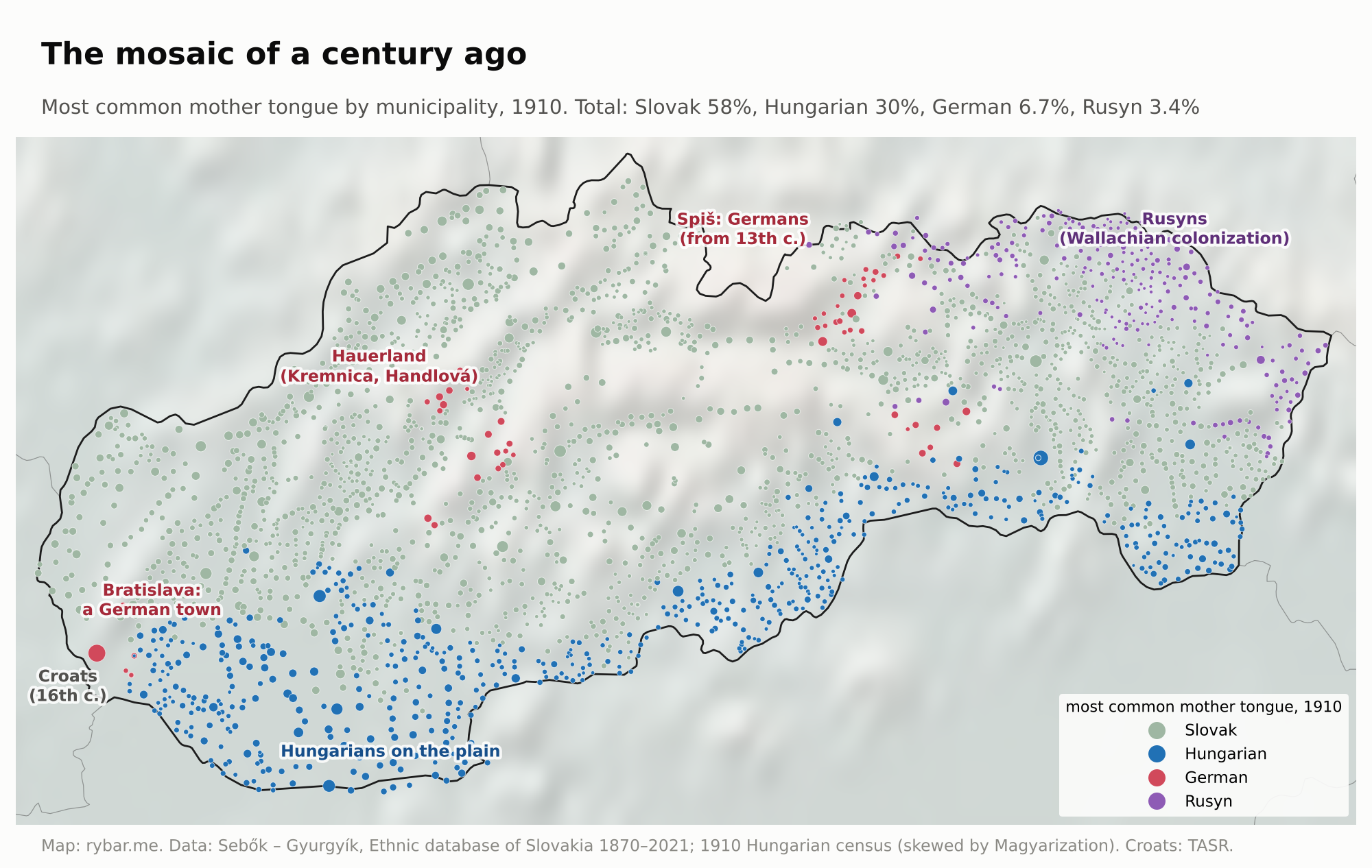
Slovaks, then, are what remains when we subtract from the Slavs of Hungary those who were set apart by something else. From the Czechs and Moravians they were separated by a state border. From the Poles by a mountain ridge, and also by a state border. From the Rusyns by rite. From the Hungarians by language. From the Croats and Serbs by distance. On the map it is the space between three lines: the Carpathian ridge in the north, the Morava River in the west and the edge of the lowland in the south.
Language makes the nation
The first attempt at a literary language of their own was made by the Catholic priest Anton Bernolák in 1787. He started from the speech of educated people around Trnava, that is, from the western Slovak dialects. Part of the Catholic clergy adopted his Slovak, and Ján Hollý wrote epics in it about Svätopluk and about Cyril and Methodius. The Lutherans stayed with Czech.
A nation with two literary languages split by religion had no future. The problem was solved by a generation that studied at the Lutheran lyceum in Bratislava in the 1830s. Its leader, Ľudovít Štúr, came up with a line of reasoning that was bold for a Lutheran. In his view, Slovaks were not a branch of a Czechoslovak tribe but a separate tribe of the Slavs, and therefore had the right, and the duty, to have a language of their own. And if it was to unite them, it could be neither the Lutherans’ Czech nor the Catholics’ Trnava Slovak. It had to be something third.
In July 1843, at the parsonage in Hlboké, Štúr, Hurban and Hodža agreed that the basis would be the Central Slovak dialect. It had three advantages. It was spoken in the middle of the country, in Turiec, Liptov and around Zvolen, so it was farthest from both Czech and Polish and the most intelligible to both west and east. Catholics and Lutherans alike spoke it. And it sounded different from Czech, which for a new nation was an argument, not a drawback.
The Bernolák camp accepted the new language in 1847 at a meeting of the Tatrín society in Čachtice. It was given its final form by the Hodža-Hattala reform of 1851. The Czechs, and Kollár with them, saw it as a schism and a betrayal of the common cause. From today’s perspective it is striking that the decision was made in a room with three men, five years before the revolution, at a time when a few thousand people read newspapers in Slovak.
On August 1, 1845, the first issue of Štúr’s Slovenskje národňje novini came out. It was published until June 1848. Anderson’s “imagined community” thus got its first tool.
Newspapers had a long prehistory in Hungary, and it is worth looking at when and where the first prints in each language appeared. The oldest book printed in Slovakia in the local language is considered to be the Bardejov Catechism of 1581, Luther’s Small Catechism in Slovakized Czech, printed by Dávid Gutgesell. The first regularly published newspaper in Hungary was in Latin: the weekly Nova Posoniensia, which began appearing on March 12, 1721, in Bratislava on the initiative of Matej Bel. The German Pressburger Zeitung was published from July 14, 1764, until 1929. The first Hungarian-language newspaper, Magyar Hírmondó, appeared on January 1, 1780, also in Bratislava. And in 1783 Prešpurské noviny, the first Slovak newspaper, began publishing there. Four languages, one city. That too belongs to the story we told in the article about Bratislava.

Bratislava was the center of Slovak printing in other ways too. In the same year as Prešpurské noviny, which was still written in a heavily Czechified Slovak, the first volume of Bajza’s novel René mláďenca príhodi a skúsenosťi, the first Slovak novel, came out here. In 1787 Bernolák published his Dissertatio in Bratislava, the first codification of literary Slovak. After the revolution the Slovak press moved: to Vienna (Slovenské noviny, 1849), Pest (Pešťbudínske vedomosti, 1861) and finally Martin (Národnie noviny, 1870). The first Slovak newspaper across the ocean came out in Pittsburgh, as we’ll see with the emigrants.
We must distinguish here between who wrote in what and who spoke in what. The dispute over the literary language was waged by a narrow circle of educated people, mostly priests, pastors, teachers and students. Hungary’s offices and schools used Latin until 1844 and Hungarian after that. Ordinary people spoke the dialect of their valley the whole time and encountered the literary language in church and later at school. So Štúr’s circle did not invent the people’s language; they chose one of its dialects and made it the language in which to address the people.

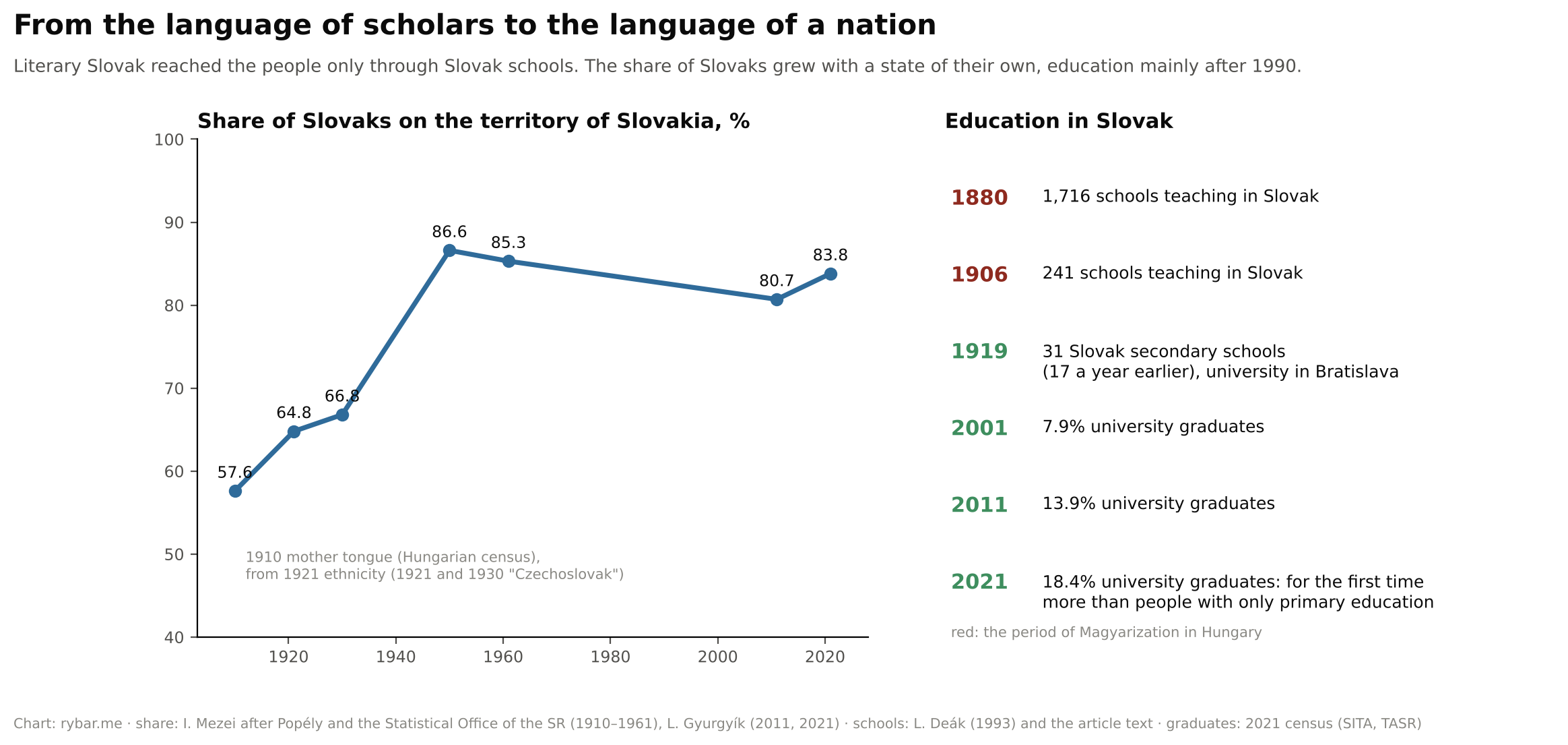
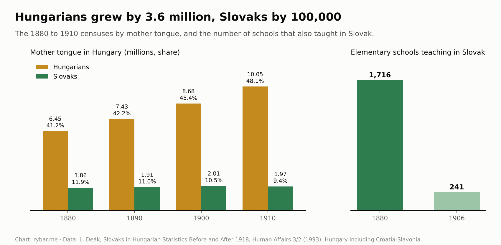
Literary Slovak reached the people only a century later, through Slovak schools. In 1880 there were still 1,716 schools teaching in Slovak in Hungary; by 1906 there were only 241. Slovak secondary schools and a university came only in Czechoslovakia. University graduates made up 7.9% of the population in 2001 and 18.4% in 2021, when for the first time there were more of them than people with only a primary education.
1848: revolution
The revolutionary wave of 1848 began in January in Sicily, hit Paris in February, and within a few weeks half of Europe was in flames. In March, Chancellor Metternich fell in Vienna; on March 15, Pest took to the streets, and other cities followed. Everywhere the same two demands rang out: a constitution and the nation. And everywhere the same problem appeared. Nations lived intermixed, and what one demanded for itself, it denied its neighbor.
In Hungary it looked like this. The Hungarians won their own government from the emperor, abolished serfdom and proclaimed civil liberties. Slovaks, Croats, Serbs and Romanians demanded from Pest the same thing Pest had demanded from Vienna, and were told that there was only one nation in Hungary. All the non-Hungarian nations therefore ended up siding with the emperor. In September the Croatian ban Jelačić invaded Hungary.
The Slovaks presented their program on May 10 and 11 in Liptovský Mikuláš. The Demands of the Slovak Nation called for recognition of the nation, Slovak in schools and offices, and a diet of their own. Pest answered with arrest warrants for Štúr, Hurban and Hodža. In June Štúr took part in the Slavic Congress in Prague.
In Vienna, on September 15 and 16, the Slovak National Council was founded and a volunteer corps was formed, made up, besides Slovaks, mainly of students from Bohemia and Moravia. On September 17 about 300 to 500 men set out from Vienna, hundreds more joined them along the way, and on September 19 an assembly in Myjava declared the Slovaks independent of Hungary. For the first time in history, someone took up arms in the name of the Slovaks.
There were three expeditions. The first, in September, came from Moravia into the scattered hill settlements around Myjava and fought on its own: Vienna even publicly distanced itself from it. On September 28, after fighting with the Hungarian home guard and imperial troops, it retreated back across the Morava. Only the next two expeditions, from December 1848, went as part of the Austrian army under Austrian command. At the same time, many Slovaks fought on the Hungarian side.
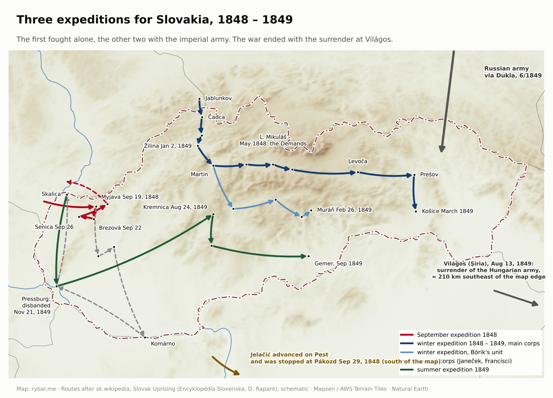
On March 20, 1849, Emperor Franz Joseph received a Slovak deputation. In September 1849 more deputations came to Vienna asking for the political and administrative separation of Slovakia from Hungary, and the emperor promised to settle Slovak demands “to general satisfaction.” In the meantime, the revolution was defeated by the Russian army, which Vienna had called in for help: on June 17, 1849, 190,000 Russian soldiers crossed the Hungarian border in Slovakia and Transylvania.
Vienna did not keep its promises. After the Hungarians surrendered at Világos, it also disbanded the Slovak volunteer corps in Bratislava on November 21, 1849; by then it had about 1,200 men.
Világos remained a symbol of defeat for the Hungarians. On August 13, 1849, they laid down their arms there before the Russians, and on October 6 the Austrians executed thirteen generals in Arad. According to legend, the Austrians clinked their beer mugs as they did so, which is why Hungarians traditionally don’t clink glasses with beer. Historian Róbert Hermann allows that winemakers may have spread the custom.
The half-century when the nation was almost not born
The program, however, survived. In June 1861 it was repeated in Martin by the Memorandum of the Slovak Nation. It called for an “Okolie,” a district in the north of Hungary with Slovak administration and Slovak schools. It was the first attempt to draw Slovakia on a map.
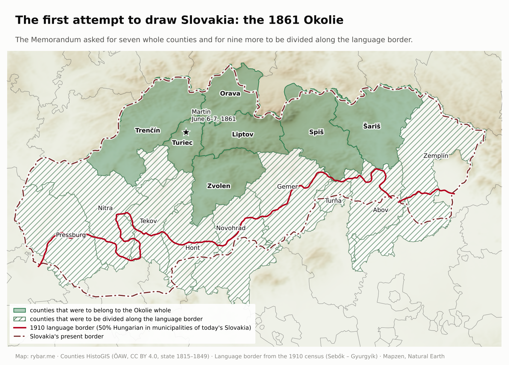
This map shows one more thing. The Okolie, the first attempt to draw Slovakia, fit almost entirely into the mountains. The language border according to the 1910 census runs along the foothills, where the mountains meet the lowland. In the 19th century the Slovaks truly were a mountain nation. We’ll come back to this image at the end.
In the 1860s it seemed that the Slovaks were following the Czech path. In 1863 Matica slovenská was founded, with a contribution from the emperor himself, and by 1869 there were three Slovak gymnasiums, in Revúca, Martin and Kláštor pod Znievom.
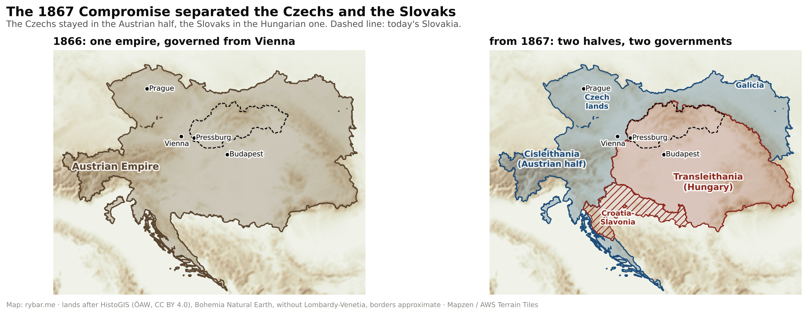
War decided the matter. In the summer of 1866 Austria lost to Prussia, and on July 22 the Prussians reached the outskirts of Bratislava. In the battle of Lamač, the last battle of the Austro-Prussian War, they attacked the Austrian line in the gap of the Little Carpathians and outflanked it over Kamzík hill. The city was saved by a truce that took effect at noon. The Austrians lost about 490 men, 61 of them killed, the Prussians about 200. A year later, defeated Vienna came to terms with Hungary. The Austro-Hungarian Compromise of 1867 gave Hungary a free hand in internal affairs.
The Compromise split the empire into two halves and left the Czechs and the Slovaks each in a different one. The Czech lands fell to the Austrian part. It was more tolerant toward its nations: Prague’s university split into a Czech and a German one in 1882, and from 1907 universal male suffrage applied in the Austrian half. Bohemia and Moravia were also the industrial core of the monarchy.
The Slovaks remained in the Hungarian part. The Nationalities Law of 1868 declared that all citizens of Hungary formed one indivisible Hungarian political nation. About six percent of the population was allowed to vote. These fifty years of diverging development are the second big reason, alongside the missing historical state, why the Czechs and the Slovaks were such unequal partners in 1918.
In 1874 and 1875 the government closed all three gymnasiums and abolished Matica. Kálmán Tisza had Matica shut down, and its property was forfeited to the state on the grounds that the Slovak nation did not exist. The Slovaks were left without a single secondary school in their own language for more than forty years. The Apponyi laws of 1907 then required that after four years of elementary school a child be able to speak and write Hungarian, and church schools that failed to ensure this lost their support. Slovak elementary schools almost disappeared.
The numbers show how it worked. Between 1900 and 1910 the number of people with Slovak as their mother tongue in Hungary fell from 2.01 to 1.97 million, even though the birth rate was high. Over the same ten years the number of Hungarians grew by 1.37 million. The difference was made up of two groups: those who became Magyarized, especially in the towns, and those who left for America.
Assimilation moved up the social ladder. Anyone who wanted to be a civil servant, a teacher, a railroad worker or an officer had to go through a Hungarian school and usually came out of it a Hungarian. In 1910 the towns on Slovak territory were Hungarian and German. The nation stayed in the village. Before 1918 the nationally conscious Slovak intelligentsia was only a handful. The rest were two million peasants who spoke Slovak but didn’t think much about the nation.
How foreigners saw the Slovaks is shown by Bram Stoker’s 1897 novel Dracula. In the very first chapter, Jonathan Harker notes that in Bistritz, in Transylvania, he saw Slovaks, who in his view were “more barbarian than the rest,” with big hats, wide dirty-white trousers and enormous leather belts. Later in the novel, Slovaks haul the count’s boxes. For the English reader, Slovaks were exotic people from the edge of Europe, not a nation.
Černová became the symbol of the era. In October 1907 gendarmes fired there on people who did not want their new church consecrated by anyone other than their native son Andrej Hlinka. Fifteen people died. The Norwegian writer Bjørnstjerne Bjørnson and the Scottish historian Robert Seton-Watson wrote about the massacre, and Europe learned for the first time that Slovaks were not just characters from adventure novels, but a nation with a problem in Hungary.
In Hroch’s scheme, the Slovak movement got stuck in phase B. It had a program, newspapers and leaders, but no schools, no towns and no middle class through which it could reach the masses. The mountains that had protected the language for a thousand years now meant poverty, few towns and poor connections. Had World War I come a generation or two later, this article might have had nothing to be about.
Leaving for bread: the Lower Lands, America and Kyrgyzstan
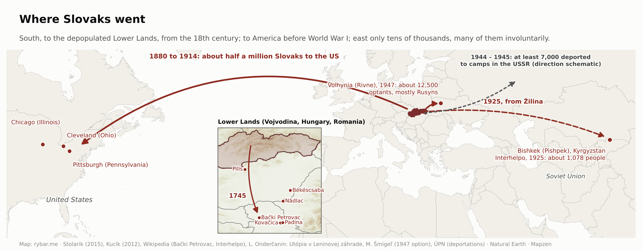
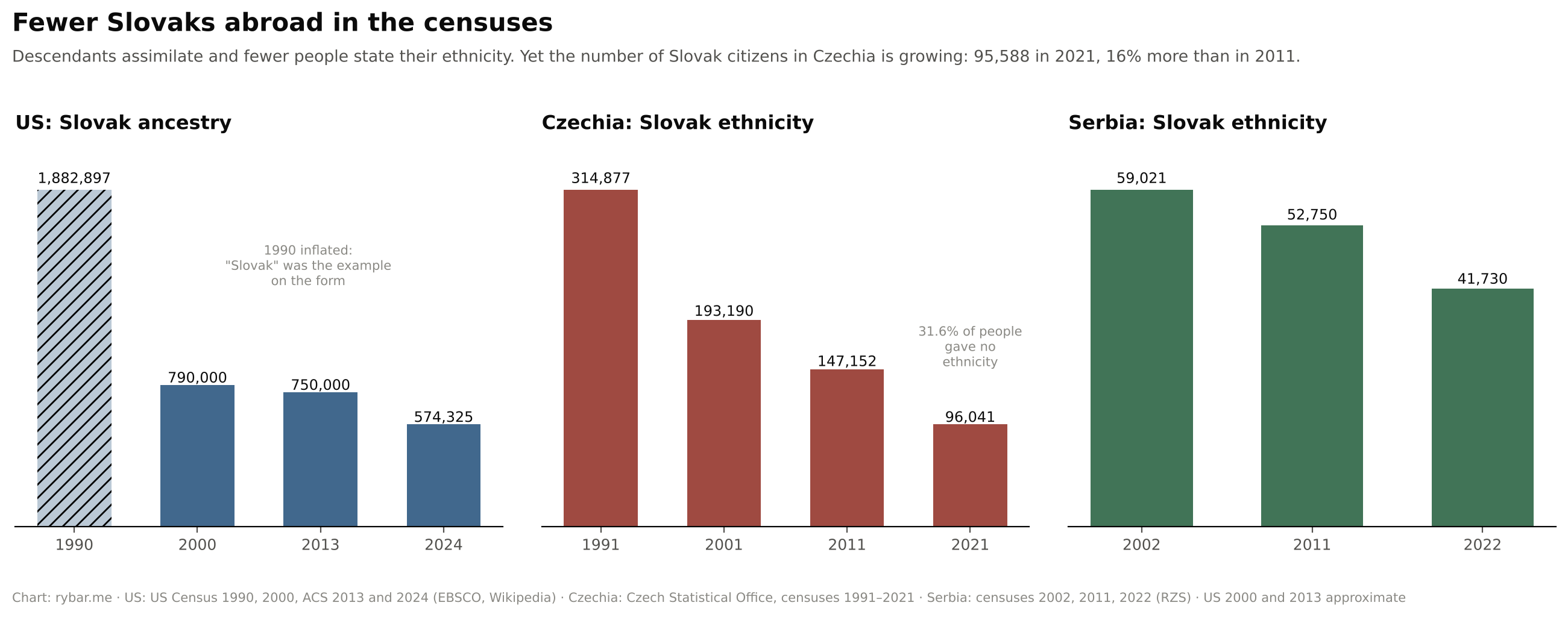
Slovaks had been leaving to earn a living for centuries. The first destination was the south. After the Treaty of Karlowitz in 1699 the Turks left most of Hungary and behind them a depopulated lowland, the Lower Lands. Landlords invited colonists there, and Slovaks from the northern counties came too. From 1718 they settled in Békéscsaba, and in 1745, 128 families came to Bački Petrovac. Slovak villages still exist today in Serbia’s Vojvodina, for example Kovačica and Padina; in Hungary, Békéscsaba and villages in the Pilis hills; in Romania, Nădlac. In Serbia’s 2022 census, 41,730 people declared Slovak ethnicity, 39,807 of them in Vojvodina. In 2002 there were still 59,021.
The second, much larger wave went overseas. Between 1880 and World War I, around half a million Slovaks left for the United States, by some estimates as many as 650,000. That was a quarter to a third of the nation. They left the poorest counties in the east and north, Šariš, Zemplín, Spiš and Orava, for the mines and steel mills of Pennsylvania, Ohio and Illinois.
Why did they leave? Historians cite economic reasons: poverty and hunger, a lack of land and work, crop failures, cholera and debt. Much of the land belonged to large estates, and peasants farmed small plots of poor soil. The turning point was 1873, when cholera and famine struck the country. Emigration began in the east, in Zemplín, Abov, Šariš and Spiš, where the first to leave were unemployed miners, craftsmen and smallholders, and from the late 1880s it spread to all of Slovakia. It peaked in the first years of the 20th century; in 1905 alone, 50,000 people left.
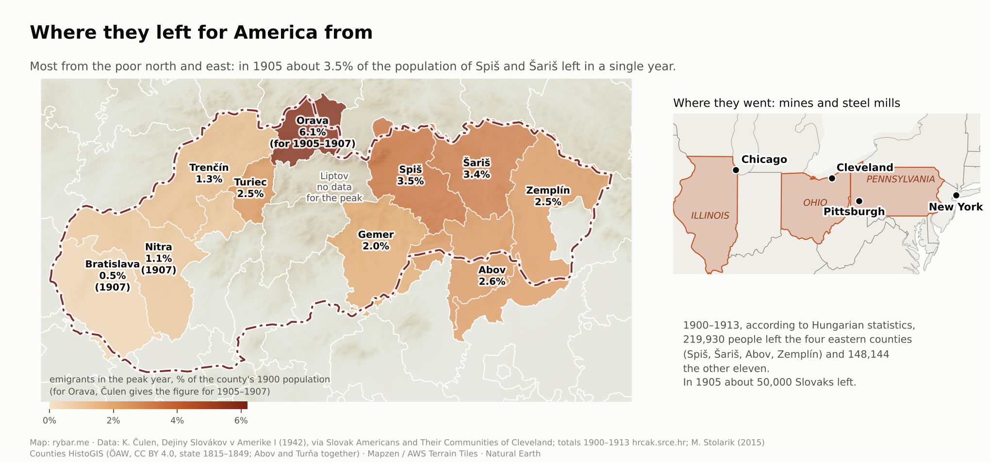
In America something happened to them that was impossible at home. For the first time they lived in a city. For the first time they had money. And for the first time no one stopped them from founding associations, newspapers, churches and schools in their own language. By 1914 the circulation of the Slovak-American press reached more than 150,000 copies, four times that of the Slovak press in Hungary. A peasant from Šariš who at home said he was “from here” learned in America, among Poles, Hungarians and the Irish, that he was a Slovak.
The first Slovak newspaper across the ocean came out in Pittsburgh: in 1885 Ján Slovenský’s mimeographed Bulletin, and a year later the printed Amerikánsko-slovenské noviny that grew out of it. On the map of the first Slovak prints in the section on language, it stands alongside Bratislava, Vienna, Pest and Martin.
When the war broke out, American Slovaks had what those at home did not: freedom of speech and money. In October 1915 they signed the Cleveland Agreement with American Czechs on a common federal state. In May 1918 Tomáš Garrigue Masaryk came to Pittsburgh and signed a second agreement with them. It promised that Slovakia would have its own administration, diet and courts in the new state. That sentence was then disputed for twenty years.
Many descendants of those emigrants still live in the United States. In the American Community Survey for 2024, 574,325 people reported Slovak ancestry; in 2000 there were about 790,000. How many of them still speak Slovak is not precisely known. In 2019, 997,098 Americans spoke a Slavic language at home, but the statistics do not list Slovak separately, and many parents did not pass it on to their children because they wanted them to be Americans.
The strangest wave went east. In 1923 the cooperative Interhelpo was founded in Žilina to help build socialism in the Soviet Union. The first train left on March 29, 1925, with about 300 people; in all, around 1,078 people went to Pishpek, today’s Bishkek in Kyrgyzstan. Among them was three-year-old Alexander Dubček with his family. The cooperative was broken up in 1932 and dissolved in 1943; some of its members ended up in the Gulag. The ideal, the disillusionment and the return are described in Lukáš Onderčanin’s book Utópia v Leninovej záhrade (Utopia in Lenin’s Garden).
Interhelpo was not the only one. From January to May 1947, under a Czechoslovak-Soviet option agreement, about 12,500 people resettled in the USSR, mostly Rusyns from northeastern Slovakia, and some villages were left nearly empty. Many later regretted it and tried to return. Even before that, in 1944 and 1945, according to the Nation’s Memory Institute, Soviet authorities deported at least 7,000 people from Slovakia to camps, mainly from the southeast and Spiš. Altogether that was about twenty thousand people, an order of magnitude fewer than the hundreds of thousands who went west. We’ll return to which way Slovaks turn when we ask whether Slovakia should go west, east, or be a bridge.
Today the direction has reversed. Since 2015, Vojvodina Slovaks from Serbia have been moving to Slovakia in large numbers: first young people to study, then whole families pushed out by the economic and political crisis at home. Historian Juraj Marušiak describes Slovakia, until now a country people left more than they came to, becoming a destination for its own expatriates as well as for people from Serbia and Ukraine. There is another side to it: the community in Vojvodina is emptying, because it is mostly the young and educated who leave, and young people are leaving Slovakia itself too.
Today Slovaks have the status of a national minority in eight countries. Officially, about 1.11 million people of Slovak origin live abroad, and expert estimates by the Slovak Academy of Sciences are even higher. Censuses in the individual countries, however, show a decline. In Czechia, more than 314,000 people declared Slovak ethnicity in 1991, but only 96,041 in 2021, although 31.6% of the population left the question blank that year. Meanwhile the number of Slovak citizens in Czechia is growing: in 2021, 95,588 lived there, 16% more than ten years earlier. The old expatriates are assimilating, and new ones are arriving for work and study.
War in the Carpathians
The wall of mountains that had stopped the Turks in the south three hundred years earlier proved itself from the north in World War I as well. In the winter of 1914 and 1915 the Russian armies tried to cross the Carpathian passes into the Hungarian lowland. They occupied Medzilaborce, and there was fighting around Humenné and Bardejov. The front got stuck in the mountains and was broken only by the German breakthrough at Gorlice in May 1915. Dozens of war cemeteries remain in the northeast. Like the Turks, the Russians never crossed the whole wall: they got stuck in the passes and the first valleys beyond them.

Slovaks fought in Hungarian regiments on the Russian, Serbian and Italian fronts. On the night of June 2, 1918, soldiers of the 71st Infantry Regiment from Trenčín mutinied in Kragujevac, Serbia. A military court sentenced 44 of them to death, and they were shot on June 8. It was the largest act of resistance against the war by Slovak soldiers.
The Legions: an army without a state
A state that did not yet exist had its own army before it had a government. Its creation is one of the strangest stories of the war.
It began in August 1914 in two places. In Kyiv, Czechs and Slovaks living in Russia formed the Czech Druzhina, which served the Russian army as scouts and interpreters. In France, 300 expatriates joined the Foreign Legion as the Nazdar Company. The real source of men, however, became the prisoner-of-war camps. Hundreds of thousands of Slavic soldiers of the Austro-Hungarian army were captured by the Russians, Serbs and Italians, and some of them were willing to fight against their own emperor.
In February 1916 the Czechoslovak National Council was founded in Paris, and recruitment was put in order. Štefánik did more for this than anyone. In 1916 he negotiated in Russia, in 1917 he recruited volunteers among expatriates in the United States, and in 1918 he arranged for legions to be formed in Italy. On July 2, 1917, a Czechoslovak brigade broke through the Austrian lines at Zborov in Ukraine, and the legions thereby won both fame and political weight in Russia.
More than 100,000 men passed through the Legions: 71,000 in Russia, 19,500 in Italy and 10,000 in France. About 7,200 of them were Slovaks, that is, seven percent. In France, where volunteers also came from among American expatriates, there were 1,591 Slovaks out of just under ten thousand.
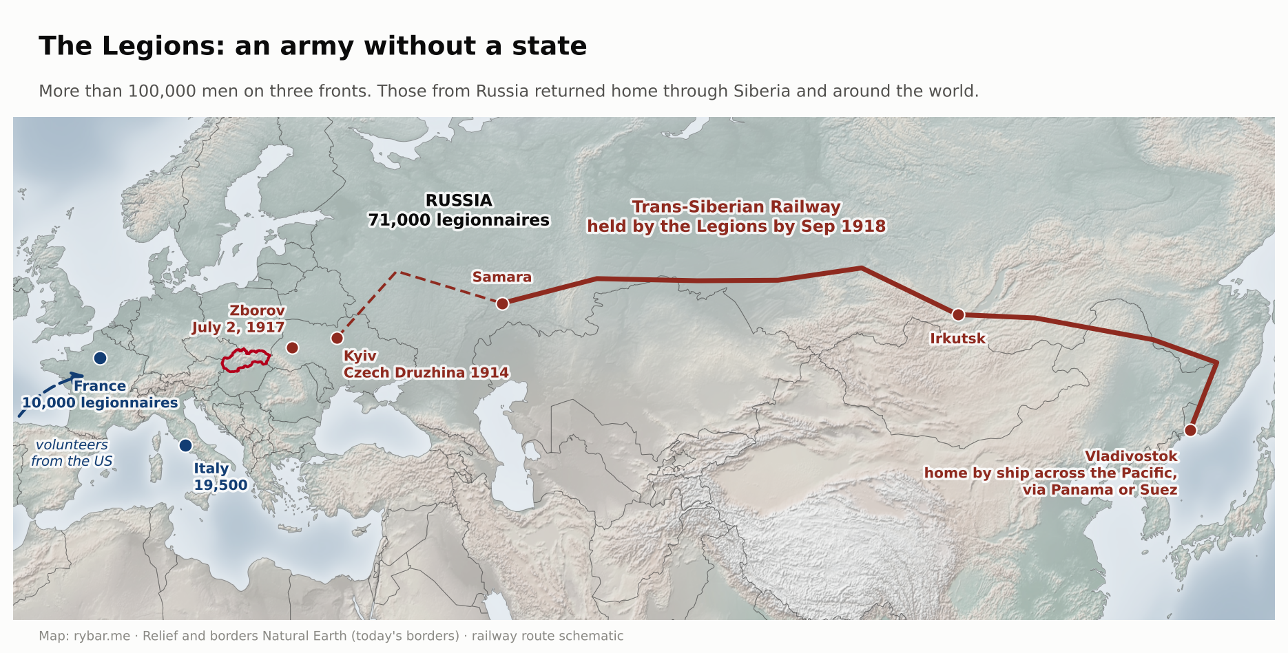
The Legions in Russia won their greatest fame, and they won it on the way home. After the Bolshevik revolution and the Peace of Brest-Litovsk in March 1918, there was no one left to fight on the Eastern Front. It was agreed that they would move to France by the longest possible route: along the Trans-Siberian Railway to Vladivostok and from there by ship around the world. The Soviet government tried to disarm the Legions, and they took up arms. By mid-July they controlled the line from Samara to Irkutsk, and by early September the entire Trans-Siberian Railway.
Why not straight west? After Brest-Litovsk, the armies of Germany and Austria-Hungary stood between Russia and France, and the way through the front was closed. The northern ports remained the only other option, but the Germans pressed the Soviet government not to allow the Legions through, and fewer than 3,000 men left via Arkhangelsk. Masaryk therefore chose the way east, around the whole world.
A small army without a state suddenly controlled Siberia, and newspapers around the world put it on their front pages. Masaryk in Washington and Beneš in Paris turned this into political capital. In the summer of 1918 the Allies recognized the National Council; the United States did so on September 3. The evacuation of the Legions from Russia lasted until the end of November 1920.
For Slovakia, the most important were those from Italy, because they returned first, as early as December 1918. Proclaiming a state was one thing; occupying it was another. Hungarian county heads and gendarmes were still in office in Slovakia. Legionnaires from Italy under Italian generals and other Czechoslovak units occupied the country step by step. By Christmas they held the Váh valley and Spiš, Prešov on December 28, Košice on December 29, and on January 1, 1919, they entered Bratislava. Petržalka, on the other bank of the Danube, was occupied only on August 14, 1919, as we described in the article about Bratislava.
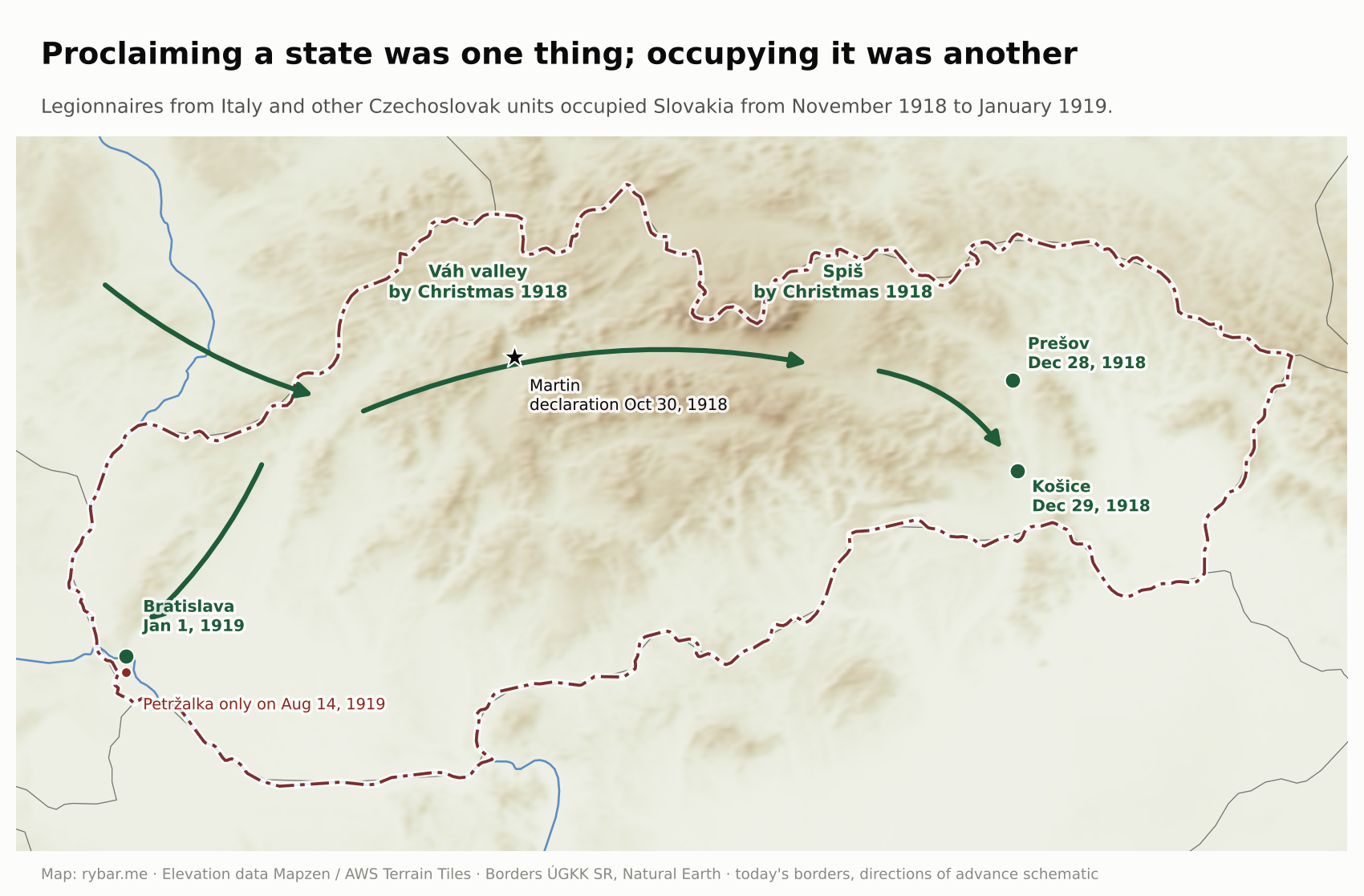
The legionnaires then formed the backbone of the new state’s army. Without them, the Martin Declaration would have remained a piece of paper.
1918: why with the Czechs
The decisive battle for Slovakia was fought in Paris, London and Washington. It was led by three men: Masaryk, whose father was a Slovak from Kopčany; Edvard Beneš; and Milan Rastislav Štefánik, the son of a Lutheran pastor from Košariská, an astronomer and a French general. They persuaded the Entente that Austria-Hungary had to be broken up and that a state of Czechs and Slovaks should take its place. Poles, Romanians, Italians and South Slavs likewise claimed their piece of the monarchy. Austria-Hungary thus gave way to seven successor states: the new Czechoslovakia, Poland and the Kingdom of Serbs, Croats and Slovenes; an enlarged Romania and Italy; and, from the rest of the core, small Austria and Hungary. Their argument was the Legions, tens of thousands of prisoners and deserters who had fought on the side of the Entente in Russia, France and Italy.
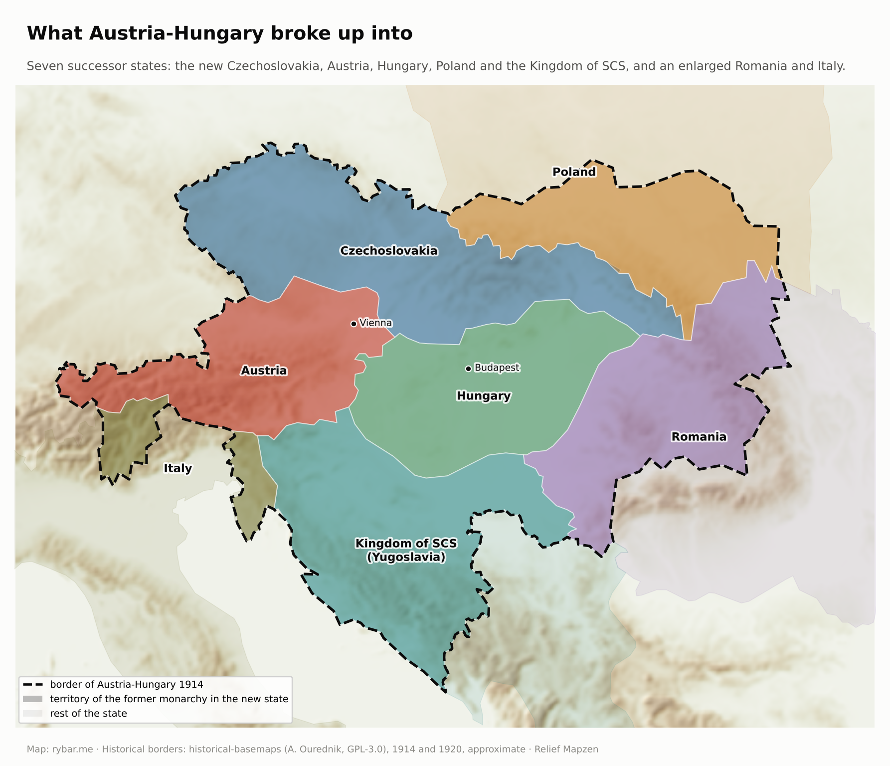
Why a common state in particular? The two sides needed each other, and the reasons were very practical.
The Slovaks would not have held out on their own. They had no army, no civil servants, no university and no industry in Slovak hands. The nationally conscious educated class was a handful. An independent Slovakia in 1918 would have been taken back by Hungary at the first opportunity, and no one would have represented it at the peace talks.
The Czechs, for their part, needed the Slovaks for the numbers. Almost three million Germans lived in the Czech lands. The 1921 census counted 8.76 million “Czechoslovaks” and 3.12 million Germans in the whole republic. There were about two million Slovaks. There were 745,000 Hungarians and 462,000 Rusyns. Without the Slovaks, the Czechs would have had only a narrow majority in the new state, and there were more Germans than Slovaks anyway. Hence the construct of a single Czechoslovak nation with two branches and a single Czechoslovak language in two versions. Kollár’s idea returned, this time as state doctrine.

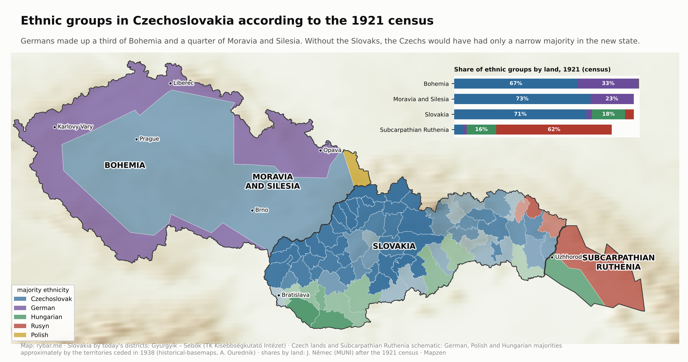
Geography, meanwhile, argued against it. As we saw at the beginning, the Czech lands and Slovakia are two different natural units. They were connected by two passes with railroads, the Vlára and the Jablunkov, and by the Morava valley. All Slovak rivers, roads and railroads led to Budapest. The new state was almost a thousand kilometers long and, at its narrowest point in Slovakia, less than a hundred wide. As we described in the first part, for the next twenty years it had to be stitched together with new railroads across the mountains. Czechoslovakia was a political project in spite of geography, and that was both its strength and its weakness.
On October 28, 1918, the Czechoslovak state was proclaimed in Prague. Two days later Slovak politicians met in Martin and, without knowing about Prague, adopted a declaration. It said that the Slovak nation was, in language and in culture and history, part of a unified Czechoslovak nation. A thousand-year bond with Hungary ended with a single sentence.
The war over the southern border
In the north and west, Slovakia’s borders were clear; they followed the old Hungarian border along the ridges and the Morava River. In the south there was no historical border. It was drawn in Paris along the Danube, the Ipeľ and the railroad lines, as we described in the first part. But first it had to be defended.
On March 21, 1919, communists led by Béla Kun took power in Budapest and proclaimed the Hungarian Soviet Republic. It had two faces. Outwardly it spread world revolution, yet many Hungarians supported its campaign to the north as a fight to restore Hungary’s borders.
At the end of April the Czechoslovak army advanced to a new demarcation line and in places crossed it. On May 20 the Hungarian Red Army counterattacked. It pushed the Czechoslovak army out of Miskolc, took Košice and Prešov, and in the south Nové Zámky and Rimavská Sobota, and penetrated as far as Zvolen. In doing so it cut the Czechoslovak army off from the Romanian one. The young republic was fighting the hardest war of its existence, and at first it was losing.
On June 16 the Slovak Soviet Republic was proclaimed in Prešov, claiming the east of the country. It lasted three weeks and depended entirely on support from Budapest; historian Jaroslav Šebek called it a cover for restoring Hungarian influence in Slovakia. With French help, the Czechoslovak army pushed the Hungarians out, and on July 7, 1919, the soviet republic came to an end.
The turning point came at the battle of Zvolen: on June 10 a Czechoslovak counteroffensive began here and retook Zvolen and Banská Štiavnica. The Hungarian withdrawal was then decided by Clemenceau’s notes and the armistice of June 24. The war cost Czechoslovakia 861 dead, 2,830 wounded and 1,960 missing; the Hungarian army reported about 450 dead, other sources 1,000 to 1,500. The border that Trianon later confirmed did not follow the old counties. It divided the counties of Pressburg, Komárom, Esztergom, Hont, Nógrád, Gemer, Abov, Zemplín and Ung, as we saw on the map of when they emerged. In the north, Orava and Spiš were divided in a similar way, with Poland getting pieces.
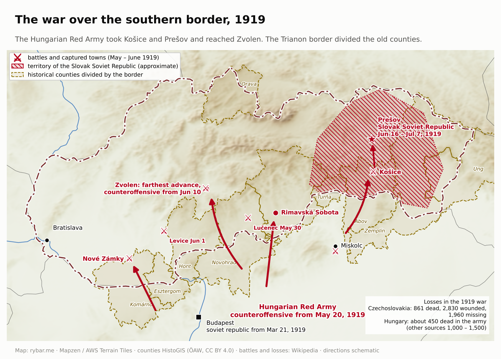
The Treaty of Trianon confirmed the border on June 4, 1920. For the first time in history, Slovakia became a territory with a line around it. More than 600,000 Hungarians remained on its Slovak side, and with them the fear that Hungary would one day come back for it. In 1938 it did. That fear survived even communism, and we’ll come back to it.
Twenty years that turned a people into a nation
What seventy years of national revivalists could not achieve, twenty years of the republic did. Hungarian officials and teachers left Slovakia, and thousands of Czechs came to take their places. In 1919 a university was founded in Bratislava, Matica was restored, and hundreds of Slovak schools opened. Slovak secondary education was built almost from scratch: 17 Slovak secondary schools began operating in the 1918/1919 school year, and by November 1919 there were 31. Twenty years later the first generation that went through Slovak schools from primer to diploma had grown up here.
It was this generation that stopped believing in a single Czechoslovak nation. The Czechs had come to help, and many stayed in the jobs young Slovaks now wanted. Prague decided everything, from taxes to railroad tariffs. Slovak industry, cut off from Hungarian markets, declined in the 1920s. And most Czechs sincerely did not understand why Slovaks should be anything other than eastern Czechs with a charming accent.
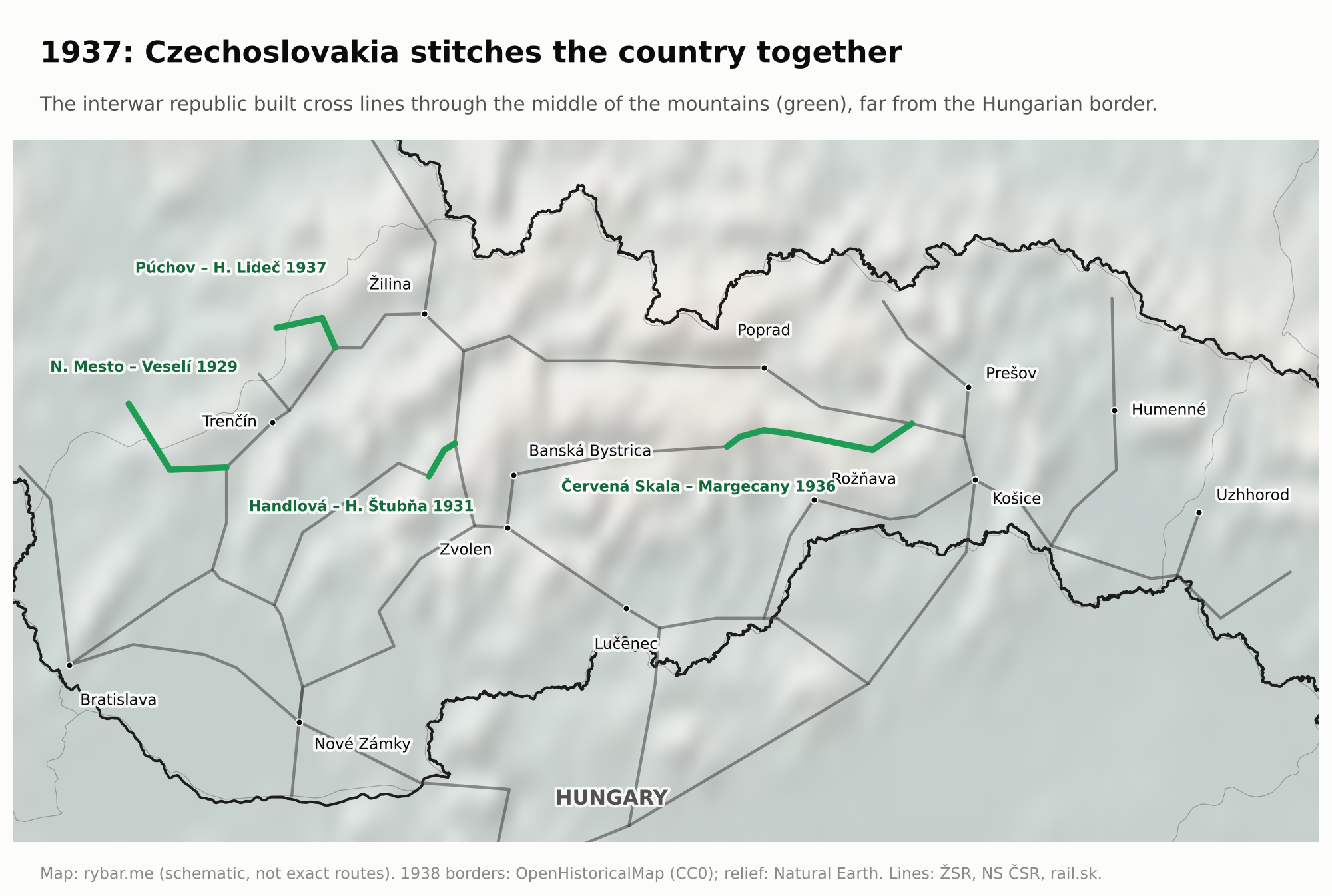
Geography was behind this too. Slovak valleys run south, toward the Danube and the Tisza, and the old roads and railroads led to Budapest. The new state needed connections from west to east, across the valleys. In 1920, members of parliament pointed out that one connection ran right along the northern border and the other along the very southern one. The republic therefore built new lines: Veselí nad Moravou – Nové Mesto nad Váhom (1929), Handlová – Horná Štubňa (1931) and Červená Skala – Margecany, opened on July 26, 1936, which together created a second east-west axis through the middle of the country.

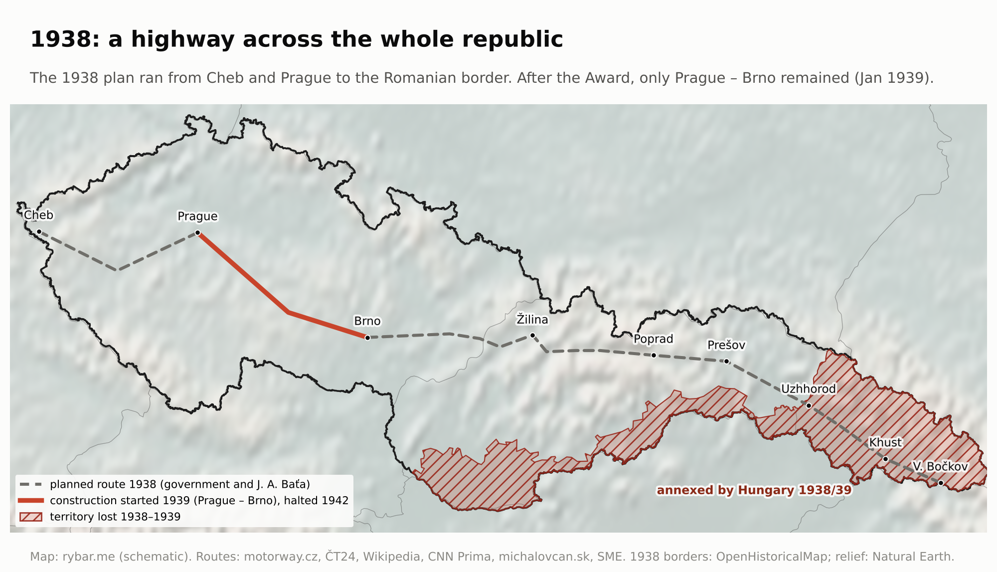
The republic also wanted to stitch the country together with a highway. As we described in the first part, the 1938 plan ran from Cheb through Prague and Brno across Slovakia all the way to the Romanian border. Munich and the Vienna Award stopped it before construction began.
The old line between the denominations added to this. Slovakia’s small political and intellectual elite was predominantly Lutheran, although Lutherans made up about 12% of the population and Catholics about 80%. Ivan Dérer, the minister plenipotentiary for the administration of Slovakia, was a Lutheran, as was the later prime minister Milan Hodža. His predecessor Vavro Šrobár was a Catholic, but a liberal who in 1919 placed Catholic church property under forced administration. Prague centralism, backed by the Hlasists, was opposed above all by Catholics. For many Slovaks the dispute with Prague thus also became a dispute about faith.
The main voice of discontent became the Catholic priest Andrej Hlinka and his People’s Party. It waved the Pittsburgh Agreement and demanded autonomy. In elections it won about a third of the vote in Slovakia. It was Catholic, conservative and increasingly authoritarian in the 1930s. Opposing it were the Slovak “Czechoslovaks,” mostly Lutherans and Agrarians, who saw the common state as a guarantee against Hungary.
Prague gave ground slowly. In 1928 the Land of Slovakia was created with a land president in Bratislava, and Slovakia became for the first time an administrative unit with its own name, though with few powers. When Nitra celebrated 1,100 years since the consecration of Pribina’s church in August 1933, supporters of Hlinka’s party disrupted the official program in front of Prime Minister Malypetr on August 13. Historians regard it as the sharpest public expression of Slovak autonomism in the entire First Republic. Five years later Slovakia got autonomy, but in circumstances nobody wanted.
The paradox of the First Republic is that the Czechoslovak school raised the Slovak nation. Hroch’s phase C, the mass movement, arrived only now, and it turned against the state that had made it possible.
A nation still coming together
In 1918 it wasn’t even clear who all belonged to the Slovaks. In the first part we wrote about a land of regions and dialects: about twenty-five dialects in three groups, each county with its own costume, market and pride. Uniting it was a hundred years’ work, and it isn’t quite finished.
The East. The eastern Slovak dialects differ most from literary Slovak. They have no long vowels, the stress falls on the penultimate syllable as in Polish, children are “dzeci” rather than “deti,” and “what” is “co” rather than “čo.” In the early 20th century the Hungarian government seized on this. It supported the newspaper Naša zastava, published from 1907 in the Šariš dialect, and the theory that easterners were not Slovaks but a separate nation of “Slovjaks.” As Hungary was falling apart, the paper’s editor Viktor Dvortsák proclaimed the Slovak People’s Republic in Košice on December 11, 1918, meant to stay with Hungary. It lasted eighteen days, until the Czechoslovak army arrived. Budapest then kept the Slovjak movement alive until the 1940s.
Záhorie. At the opposite end of the country, the people of Záhorie speak a dialect that blends smoothly into Moravian. Across the Morava River, already in Czechia, lies a region called Slovácko, whose people are “Moravian Slovaks.” In costume, song and speech they are closer to Skalica than to Prague. Yet today there are Slovaks on one side of the river and Czechs on the other. That was decided by the border that ran there for a thousand years, not by language.
Moravians. The neighbors show that national unification is not finished anywhere. In the 1991 census, 1.36 million people in Czechia declared Moravian ethnicity. In 2021 there were about 360,000, and together with those who gave it in combination with another, mostly Czech, more than 550,000. Moravia had its own diet, its own capital and, in the 9th century, its own realm. Slovakia had none of that, and yet it became a nation while Moravia remained a region. The difference is that a kingdom’s border never separated the Moravians from the Czechs. Nor did nature protect them from them. The Bohemian-Moravian Highlands were forested and sparsely settled, but passable, and Moravia has no wall of mountain massifs around it the way Bohemia does. Prince Oldřich took it from Poland in 1019 or 1029, entrusted it to his son Břetislav, and it has been part of the Czech state ever since.
Gorals and Rusyns. In the north, Slovakia and Poland disputed the Goral villages from 1918 to 1920 and again in 1938, and the Gorals themselves still say they are above all Gorals. The Rusyns have been a recognized minority since 1991 and codified their own literary language in 1995. In the 2021 census, 23,700 people gave Rusyn as their first ethnicity and another 39,800 as their second, 63,600 in total, almost twice as many as ten years earlier.
The Roma. The largest minority is the one least talked about in the Slovak national story. Maria Theresa and Joseph II wanted to turn them into settled “new peasants,” the wartime state sent them to labor camps, and in 1958 the communist regime banned nomadism by law. Many Roma today live in settlements in the east and in the south of central Slovakia, apart from the majority. In our view, this is the biggest unfinished task of the unification this chapter is about.


Meanwhile, the dialects are fading. Schools did it, along with radio from 1926, television from 1956, migration to the cities and military service. Today’s twentysomethings from Prešov and Senica understand each other without trouble; their grandparents would have had to make an effort. Regional identity has not disappeared, though; it has only changed form. Being an easterner today is more an attitude toward Bratislava than a dialect. And to the rest of the country, a Bratislava resident is a category of their own, as the election maps at the end will show.
Slovak’s closest relatives
Slovak lies in the middle of the Slavic world, quite literally. To the west it borders Czech, to the north Polish, to the east Rusyn and Ukrainian. Hungarian and German separate it from the South Slavs.
The closest is Czech. The two languages are mutually intelligible without study and form a dialect continuum: from Cheb to Uzhhorod, speech changes from village to village in small steps, with no sharp border. The differences are mostly in sounds. Czech has ř, ě and ů; Slovak has ä, ô, ľ, the diphthongs ia, ie, iu, and a rhythmic law that does not allow two long syllables in a row. About 15% of the vocabulary differs. Since the split of the state, intelligibility has been weakening: there is less Slovak on Czech radio and television, and young Czechs understand it less well than their parents.
Polish is the second closest, with the eastern Slovak and Goral dialects forming a bridge to it. Rusyn is an East Slavic language, but after centuries of living side by side, an easterner understands it more easily than a Prague resident from Vinohrady understands literary Czech.
The most interesting kinship is the one we wouldn’t expect. The Central Slovak dialects, and therefore literary Slovak too, have features otherwise found only among the South Slavs. A Slovak says šilo for “awl,” a Czech šídlo. The Slovak lakeť, “elbow,” begins differently from the Czech loket. In some Central Slovak dialects people say nosímo instead of nosíme, “we carry.” Linguist Rudolf Krajčovič explained this by saying that central Slovakia was settled by Slavs who came from the south, from the Danube, while the west and the east were settled by a stream from the north. Slovak is thus a West Slavic language with a trace of the south, a reminder of the time when Hungarian Pannonia did not yet separate Slovaks from Slovenes.
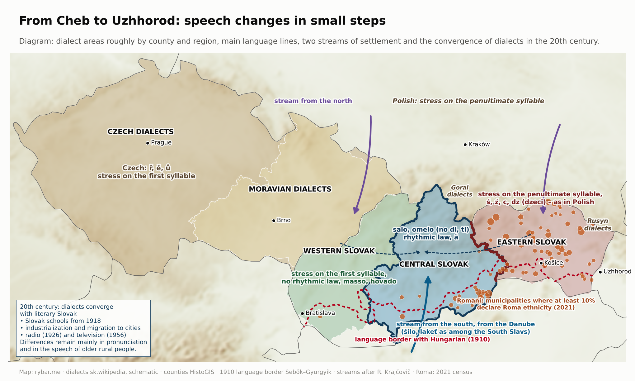
That’s why people sometimes say Slovak is the Slavic Esperanto, a language all Slavs understand. That’s an exaggeration, but there is a grain of truth in it. Whoever stands in the middle is close to everyone.
A question arises here. If speech changes gradually and neighboring valleys always understood each other, why did separate nations form exactly where they did? Because language borders are drawn not by dialects but by states. Linguist Max Weinreich popularized a line he had heard from a member of his lecture audience: a language is a dialect with an army and a navy.
Imagine two villages, one on the Slovak and one on the Moravian side of the White Carpathians, that spoke almost the same way in 1800 (this is an illustration, not a documented example). But one belonged to a Hungarian county, the other to the Moravian governorship. One had a Lutheran pastor who read the Kralice Bible and later Štúr; the other had a Catholic parish and a school with Czech and German. One took its grain to Trnava and Pest, the other to Brno and Vienna. When compulsory schooling and newspapers came in the 19th century, each was pulled toward a different literary language. The continuum remained, but a line cut through it, and that line was a thousand years older than both literary languages.
It was the same in the north with the Poles and in the east with the Rusyns. Slovak did not become a separate language because it was very different. It became separate because for a thousand years its speakers were held together by the same mountains, the same rivers flowing south, the same kingdom and, in the end, the same enemy.
1938 to 1945: a state by someone else’s will
The first Slovak state did not come into being because the Slovaks fought for it, but because Czechoslovakia fell apart. After Munich, the People’s Party declared autonomy in Žilina on October 6, 1938. A month later came the Vienna Award, and Slovakia lost its southern strip with Košice. Poland took 226 km² in Kysuce, Orava and Spiš, and Germany took Petržalka and Devín. On March 13, 1939, Hitler summoned Jozef Tiso to Berlin and gave him a choice: independence under German protection, or partition between Hungary and Poland. The next day the diet proclaimed the Slovak State.
Nine days later, on March 23, 1939, Hungary attacked in the east. In the Little War it occupied a strip of territory along the border with Subcarpathian Ruthenia, and on April 4 Slovakia ceded to it 78 municipalities, 1,697 km² with about 70,000 inhabitants. In five months the country thus lost the plain in the south and a piece of the open east. The mountains in the north lost only a little.
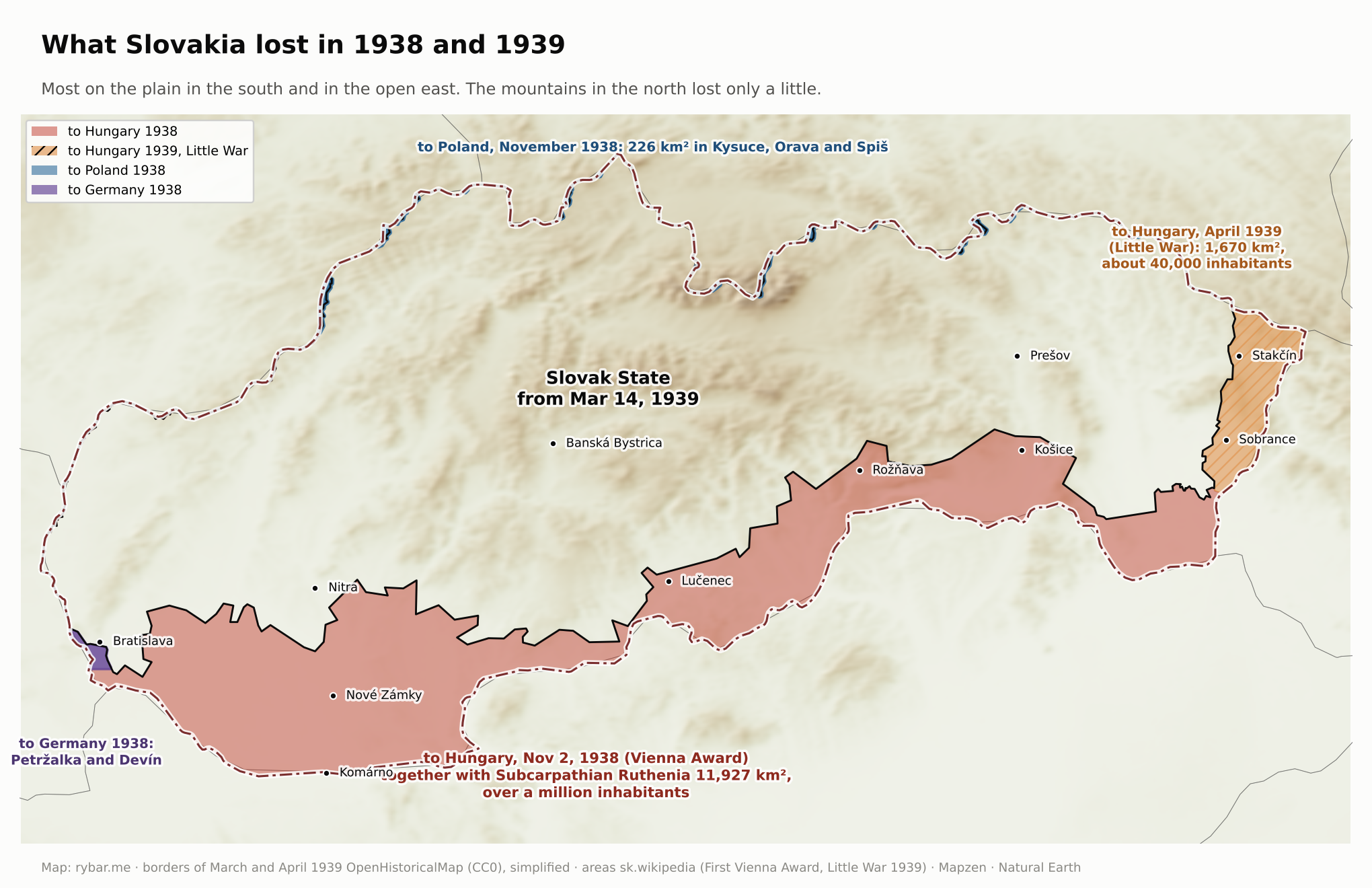
It had a president, a government, an army, a currency, and 27 states recognized it. Many Slovaks experienced for the first time that offices, schools and the army were Slovak, and part of the collective memory preserves it that way to this day. But it was a one-party state that sent soldiers against Poland and the Soviet Union and that got rid of its own citizens. In 1942 it deported almost 58,000 Jews to extermination camps and paid Germany 500 Reichsmarks for each of them. In all, about 70,000 Slovak Jews perished. Today’s Slovak Republic does not consider itself the successor of this state.
Slovaks also stood on the other side. Jozef Gabčík, a native of Poluvsie near Rajecké Teplice, attacked Reinhard Heydrich in Prague together with Jan Kubiš on May 27, 1942. Heydrich died on June 4. Gabčík was killed on June 18, 1942, in the crypt of the Church of Saints Cyril and Methodius in Prague.
Gabčík and Kubiš were sent from London by Edvard Beneš’s Czechoslovak government-in-exile. Britain recognized it provisionally in July 1940 and fully on July 18, 1941, the same day as the Soviet Union. For that government and for most of the Allies, Slovakia remained part of Czechoslovakia, whose breakup they did not recognize. The Slovak State was thus recognized by Germany, its allies and some neutral countries, but the victors of the war did not consider it a state.
The first answer to the question of what Slovaks wanted to be was given by the wartime state, born of Hitler’s will. The second was given by the uprising. The Slovak National Uprising broke out on August 29, 1944, and its center became Banská Bystrica in the middle of the mountains, not Bratislava on the plain. That was no accident. The military headquarters under Ján Golian worked at the ground forces command in Banská Bystrica and planned the uprising’s center of gravity in the triangle of Banská Bystrica, Zvolen and Brezno. Since 1938 Bratislava had lain right on the border with the German Reich, which had also taken Petržalka on the other bank of the Danube, and Tiso’s government sat there. We discussed why a capital on the edge cannot be defended in the previous part, Why Is Bratislava on the Edge?; in a wartime state squeezed from two sides, that was doubly true.
The Bratislava garrison was disarmed on the very first day, and on August 30 the Free Slovak Radio went on the air from Banská Bystrica. The plan counted on the East Slovak Army, two divisions north of Prešov, opening the Carpathian passes to the Red Army. But the Germans disarmed it almost without a fight on August 31 and September 1. Garrisons in the west, including Bratislava and the Váh valley, did not join the uprising. The insurgent territory thus shrank to central Slovakia, the upper Nitra valley and part of Spiš, a mountain fortress with the Tri Duby airfield at its center.
Those who prepared the uprising’s economic side knew this too. From March 1944, under the pretext of evacuation, the governor of the Slovak National Bank, Imrich Karvaš, had most of the currency reserves, about 3.85 billion korunas, concentrated in the branches in Banská Bystrica and Ružomberok. As head of the Supreme Supply Office, he also moved fuel, food and shoes to central Slovakia and had people issued rations three months in advance. The insurgent national bank then financed both the army and the civil administration from this money. Karvaš was arrested by the Gestapo and sentenced to death; he survived.

Help came slowly across the mountains. The Carpathian-Dukla Operation began on September 8 and was supposed to last five days. The Dukla Pass was taken only on October 6, the fighting continued until October 28, and the advance stalled south of the pass. Banská Bystrica fell on October 27. The mountains that protected the insurgents also kept them from linking up with the Allies. The front then moved across Slovakia from valley to valley until the spring of 1945.

In a sense, this was the Slovaks’ second uprising against their own state. The first was in 1848, when volunteers in Myjava declared secession from Hungary, which was then their state. In 1944 they rose against a state that had a Slovak name but was born of Hitler’s will. Both times they rebelled in the name of the Slovaks, and both times they lost militarily. In 1848 they gained nothing politically, but the uprising gave the national movement its first army, heroes and program. In 1944 the uprising won Slovakia a place among the victors. That is our interpretation.
Militarily, the uprising was lost. Politically, it decided two things. Slovakia ended the war on the side of the victors, even though it had begun it on the side of the defeated. And already in the Christmas Agreement of December 1943, the Slovak National Council had committed itself to restoring Czechoslovakia on the principle of “equal with equal.” The idea of a single Czechoslovak nation never returned. That may be the uprising’s greatest political legacy: Slovaks entered the restored state as a separate nation, not as a branch of a Czechoslovak one.
1945 to 1989: a federation on paper
The Košice Government Program of April 1945 recognized the Slovaks as a distinct nation and the Slovak National Council as its body. An asymmetric arrangement emerged: Slovakia had its own legislature and government, the Czech lands did not, and Prague stood above both. Within a year, three Prague agreements had whittled down Slovak powers.
The May 1946 elections showed how differently the two parts of the state thought. In the Czech lands the communists won with 40%. In Slovakia the Democratic Party won 62% and the communists 30%. Two years later the communists took power in the whole state, and the Slovak question became suspect. In the 1950s Slovak communists, including Gustáv Husák, were tried for “bourgeois nationalism,” and the 1960 constitution abolished even the remnants of a Slovak government.

The 62% figure needs to be read carefully. The Democratic Party was born in the uprising and was led mostly by Lutherans. The People’s Party was banned after the war, and its voters, the majority of Catholics, had no one to vote for. Before the election, the mostly Lutheran leadership of the Democrats therefore concluded the April Agreement with Catholic representatives and promised to seek clemency for Jozef Tiso. Sixty-two percent was thus not the vote of one party with one program, but the joint vote of those who didn’t want the communists, including voters of the banned People’s Party. The communists saw the Tiso trial as a way to attack the Catholic wing of the Democrats. The court handed down a death sentence on April 15, 1947, President Beneš did not grant clemency, and Tiso was executed on April 18. The Democratic Party’s popularity then declined.
1968: tanks and federation
In January 1968 a Slovak, Alexander Dubček, became the head of the Communist Party. On the night of August 20 to 21, 1968, Warsaw Pact troops occupied Czechoslovakia. In all, about half a million soldiers and 6,300 tanks took part, 165,000 soldiers and 4,600 tanks in the first wave. In the first phase, 48,000 Soviet, 10,300 Hungarian and a thousand Bulgarian soldiers entered Slovak territory. They came through gates we already know: the Soviets from Transcarpathia across the eastern border and from Hungary, the Hungarians through the open south. Thirty years after the Vienna Award, Hungarian troops were thus in Slovakia again. By the end of 1968, 108 people had died, 37 of them in Slovakia. The strongest protests were in Košice; in Bratislava the student Danka Košanová was killed.
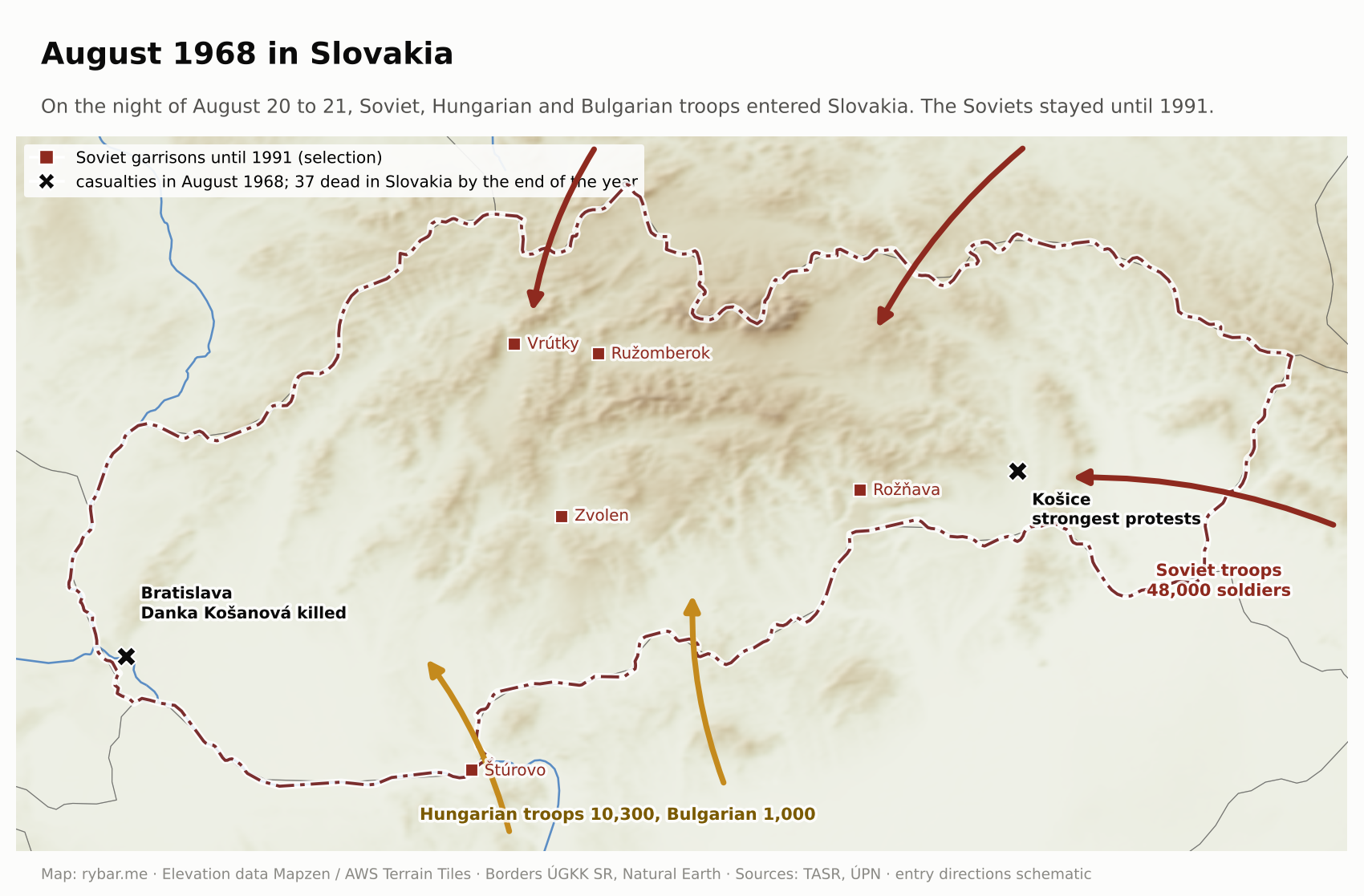
The other armies left between October 18 and November 4, 1968. The Soviet one stayed. The treaty on the stationing of Soviet troops was signed on October 16, 1968, and there were garrisons in Slovakia too, for example in Rožňava, Ružomberok, Štúrovo, Vrútky and Zvolen. The last 73,500 Soviet soldiers left between February 1990 and June 1991. Over the whole period of the occupation, more than 400 people died.
Of the entire Prague Spring, only one reform survived the Soviet occupation. The constitutional law of October 27, 1968, turned the unitary state into a federation of the Czech Socialist Republic and the Slovak Socialist Republic from January 1, 1969. The Slovak Republic has thus existed since 1969, not since 1993. Real power remained with one party with one center, and amendments in 1971 hollowed out the federation. But the shell remained: borders, a parliament, a government, ministries, a capital. When the regime fell in 1989, all that was needed was to fill it.
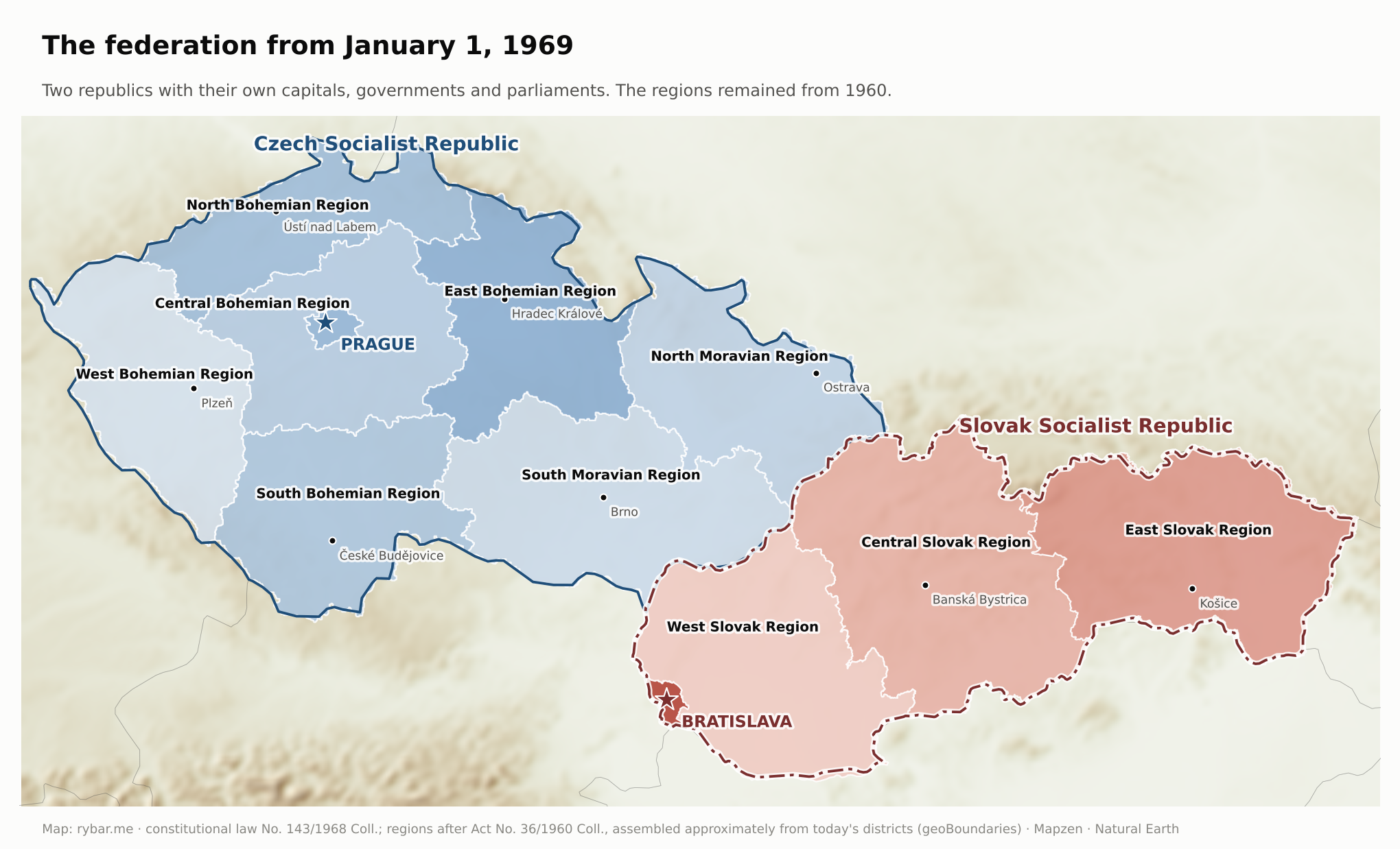
The “normalization” after 1968 was also milder in Slovakia than in the Czech lands: political persecution was less harsh and more selective, and 17.5% of party members lost their membership cards, compared with 21.7% in the state as a whole. This fits with how people in Slovakia relied more on family and acquaintances than on the state, which we’ll come back to at the end.
November 1989: Public Against Violence
In the fall of 1989, the communist regimes of Central Europe fell one after another. In Poland, Tadeusz Mazowiecki’s government had been in power since August, Hungary opened its border with Austria, and on November 9 the Berlin Wall fell. In Prague on November 17, police brutally broke up a student march on Národní třída. That set off the Velvet Revolution, which ended communist rule within six weeks: on December 29, 1989, parliament elected Václav Havel president.
In Slovakia, November 1989 began a day earlier than in Prague: on November 16, students marched through Bratislava. On November 19 the movement Public Against Violence was founded at the Umelecká beseda in Bratislava; Ján Budaj, Milan Kňažko and Fedor Gál were among its founders. The Slovak revolution thus had its own movement and its own center in Bratislava from the start. On November 24 television broadcast the first Studio Dialóg; on November 27 a general strike was held from noon to two with about 75% participation; and on November 29 parliament abolished the leading role of the Communist Party. The first free elections were held on June 8 and 9, 1990. In the spring of 1991 Public Against Violence split, and part of it became Vladimír Mečiar’s Movement for a Democratic Slovakia.
The revolution was not just a Bratislava affair. On November 23 about 100,000 people gathered on SNP Square in Bratislava, and there were rallies in Banská Bystrica, Košice, Prešov, Trnava, Žilina and Poprad too.

1989 to 1993: a divorce without a vote
After November 1989 it became clear that Czechs and Slovaks imagined different things under a common state. The first dispute was over a hyphen. From December 1989 to April 1990, parliament argued over whether the state would be called the Czechoslovak or the Czecho-Slovak Federative Republic. The hyphen really mattered to Slovaks: in their view, a name without it diminished Slovakia’s equal standing. The result was the name Czech and Slovak Federative Republic.
Behind the hyphen lay more serious matters. Economic reform hit Slovakia harder. Arms factories and heavy industry, built for Warsaw Pact markets, lost their buyers, and unemployment in Slovakia was several times higher than in the Czech Republic. The Czech side wanted a functioning federation with a strong center, or nothing. The Slovak side wanted a union of two sovereign republics. Two years of talks at castles and chateaux led nowhere.
Slovak nationalists reproached Prague mainly for five things. Each is worth looking at from the other side too.
- The arms factories. Arms production in Slovakia fell by 94.4% between 1988 and 1992, and the production of tanks, infantry fighting vehicles and artillery practically stopped. For many, this was proof that the new Prague had sacrificed Slovak factories. According to military historians, however, the decline began as early as 1988, before the revolution, and the main cause was the collapse of the Warsaw Pact and its markets, not a decision by Prague. Still, it hit Slovakia harder, because socialist industrialization had concentrated the arms factories here.
- Who subsidizes whom. Slovaks believed their money ended up in Prague. Czechs believed they were subsidizing Slovakia. In fact, transfers from the Czech budget to Slovakia were the rule until January 1991, when they stopped. So the Czechs had numbers to back their feeling. Slovaks objected that the numbers didn’t capture prices: Slovak raw materials and semi-finished goods went cheaply to Czech plants, and the profit was made only there.
- A reform tailored to the Czechs. Rapid liberalization and privatization were easier to bear in a country with diverse industry close to the German border. At the time of the 1992 election, unemployment in Slovakia was three times higher than in the Czech lands. From Prague’s point of view, however, a slower reform would only have meant a longer agony, and high unemployment was the legacy of a structure dictated to Slovakia by the planned economy, not by Klaus’s reform.
- Invisibility. All federal offices, embassies and foreign trade companies were based in Prague. The world knew the Czechs and shortened “Czechoslovakia” to “Czech.” Czechs, in turn, pointed out that Slovakia had had its own government and parliament since 1969, while the Czech republic-level government stood in the shadow of the federal one, and no one actually cultivated a separate Czech identity.
- Condescension. The feeling that Czechs treated Slovaks as a younger brother who needed to be brought up can’t be measured, but it is everywhere in surveys and memoirs. From the Czech side it often looked the other way around: as ingratitude for the interwar schools and civil servants, and as a nationalism that threatened the common state after 1989.
Added to this was the mood of the time. Havel’s amnesty of January 1990 covered a large share of prisoners. About 600 of the 2,500 convicts in Leopoldov were released, and those who remained rioted in March 1990. It was the largest prison riot in the history of Czechoslovakia, and the army helped put it down. The impression spread that the amnesty had caused a sharp rise in crime. Statistics don’t bear this out, since amnestied prisoners accounted for only nine percent of crime in 1990, but the feeling that order had left along with communism remained.
An interpretation of history that had survived in exile for forty years, and that the wartime state had celebrated, returned as well. Exile historians played a key role: František Vnuk, in the 1990s a professor of church history at the theological faculty in Bratislava, and Milan S. Ďurica. Ďurica, a professor in Padua, Italy, published Dejiny Slovenska a Slovákov (A History of Slovakia and the Slovaks) in 1996 with the Slovak Pedagogical Publishing House, intended mainly for history teachers. As early as July 8, 1990, a memorial plaque to Jozef Tiso was unveiled in Bánovce nad Bebravou, and the federal government issued a special statement about it. In the 1992 election to the Slovak National Council, the Slovak National Party won 7.93%. It claims the tradition of the original SNS from 1871, but is not its successor. That party was swallowed by Hlinka’s People’s Party in November 1938: it forced the other Slovak parties to merge with it into the Party of Slovak National Unity and banned the rest. Ten years later the communists did the same, folding the remaining parties into the National Front.
The June 1992 elections were won in the Czech Republic by Václav Klaus’s ODS with 33% and in Slovakia by Vladimír Mečiar’s HZDS with 37%. Neither party had splitting the state in its program. Mečiar wanted a confederation; Klaus rejected it. On July 17 the Slovak National Council adopted the Declaration of Sovereignty, Václav Havel resigned as president, and on September 1 the Slovak constitution was approved. In August, Klaus and Mečiar agreed on the split at Villa Tugendhat in Brno. The Federal Assembly approved it by a narrow majority on November 25, and at midnight on December 31, 1992, Czechoslovakia ceased to exist.
There was no referendum. A petition calling for one had been signed by two and a half million people back in 1991. In a September 1992 poll, 37% of Slovaks and 36% of Czechs were in favor of the split. The state that Štúr, Hlinka and the insurgents had strived for thus came into being, in the end, by the decision of two prime ministers who couldn’t agree on anything else.
This can be read in two ways. According to the first, the split was illegitimate, because the majority didn’t want it. According to the second, it showed that the nation was complete. No one shot, no one fled, the border was drawn where it had been for a thousand years, and the property was divided two to one. At the same time, a war was being fought in Yugoslavia. Slovaks and Czechs were lucky with their geography: there were no mixed territories or disputed cities between them.
Where the border ran. There was nothing to negotiate. The administrative border between the Czech and Slovak republics was the same line that had separated Hungary from Moravia since the Middle Ages: the Morava River, the White Carpathians, the Javorníky and the Beskids. The 1996 border treaty, in force from July 1997, made eighteen small adjustments to it, and the two sides exchanged exactly the same area, 452 hectares. The hamlet of U Sabotů went to Slovakia, part of the hamlet of Sidónia to the Czech Republic. Slovakia’s oldest border thus became its youngest state border.
With the split, Slovakia for the first time found itself alone with its geography: a long, narrow shape, a capital on the western edge and mountains in the middle. The task Czechoslovakia had tackled across the valleys, connecting west with east, fell to the new state, and as the first part of the series showed, it drags on to this day.
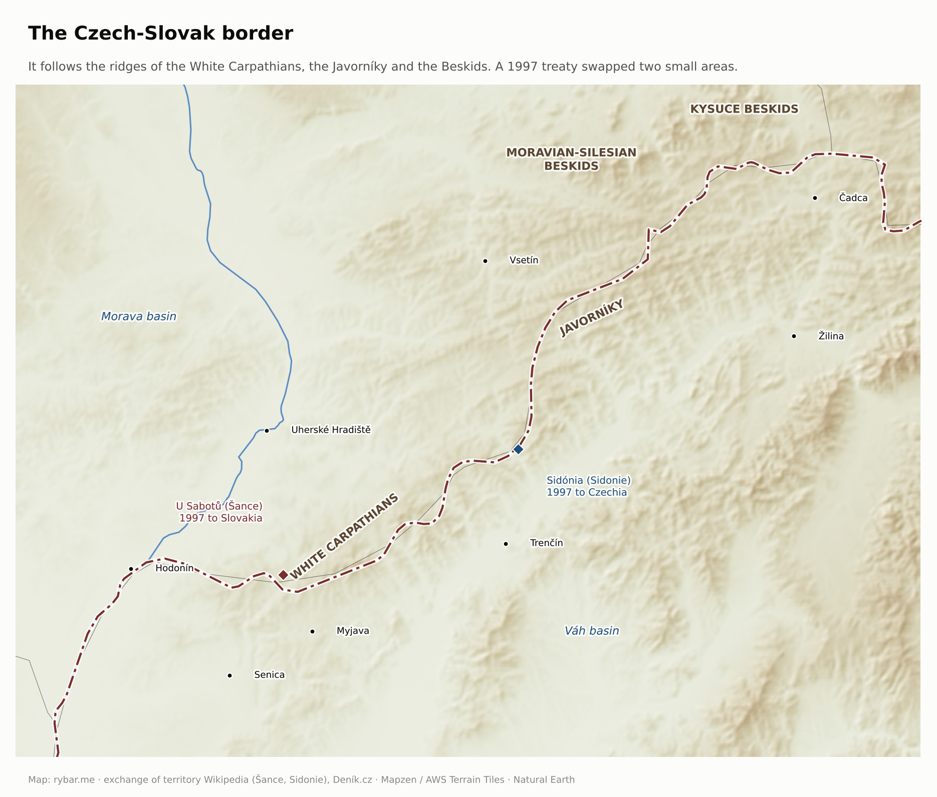
How the property was divided. Real estate stayed with whoever’s territory it stood on. Movable property and property abroad were divided two to one. And the Czech Republic kept the Czechoslovak flag, even though the law dissolving the federation barred the successor states from using its symbols. The common currency lasted only until February 8, 1993.
Who owns the victories. The past had to be divided too. In hockey, the international federation recognized only the Czech Republic as the successor of Czechoslovakia and placed Slovakia in the lowest group, Pool C. Slovakia won it in 1994 and Pool B in 1995, and has played among the elite since 1996. Between 2000 and 2003 it won three medals at world championships. For a country with so few victories in its pantheon, it was an experience everyone who saw it remembers. In soccer, too, the Czech Republic took over Czechoslovakia’s achievements after 1992. UEFA eventually credited the 1976 European Championship title to both countries, however, and Slovakia received its own trophy.
Fear of the south. It is hard to imagine today, but after independence the “Hungarian threat” came up again and again in the language of the ruling elite around Vladimír Mečiar. From 1993 to 1998 Slovakia spent the largest share of GDP on its army of the Visegrád Four countries. The idea drew on the memory of 1919 and 1938 and on fresh reasons. Right after his election in 1990, Hungarian Prime Minister József Antall declared that he wanted to be, “in spirit,” the prime minister of fifteen million Hungarians, including those beyond the borders. In May 1992 Hungary terminated the treaty on the Gabčíkovo-Nagymaros dam, and on October 24, 1992, two months before the split, the damming of the Danube began despite its protests. The dispute ended up before the International Court of Justice in The Hague. Only on March 19, 1995, did Prime Ministers Vladimír Mečiar and Gyula Horn sign a basic treaty in Paris in which both countries confirmed the inviolability of their borders and declared they had no territorial claims against each other. The border that was fought over in 1919 today has not even a barrier.
The fear of the south can also be looked for on the highway map that the first part of the series, Why Is Slovakia So Long and Thin?, was about. According to estimates from the beginning of this century, the southern route from Bratislava to Košice was to cost 40 to 50 billion korunas, the northern one about 100 billion. The northern D1 through Žilina, Liptov and Prešov won. About half of the southern R2 route runs through territory Slovakia lost in 1938, through Lučenec, Rimavská Sobota and Rožňava to Košice. We found no document justifying the choice of the northern route on defense grounds; the ministry defended it as an international corridor. The fact remains that the northern highway is more expensive and slower to build, but it runs through territory Slovakia never lost.
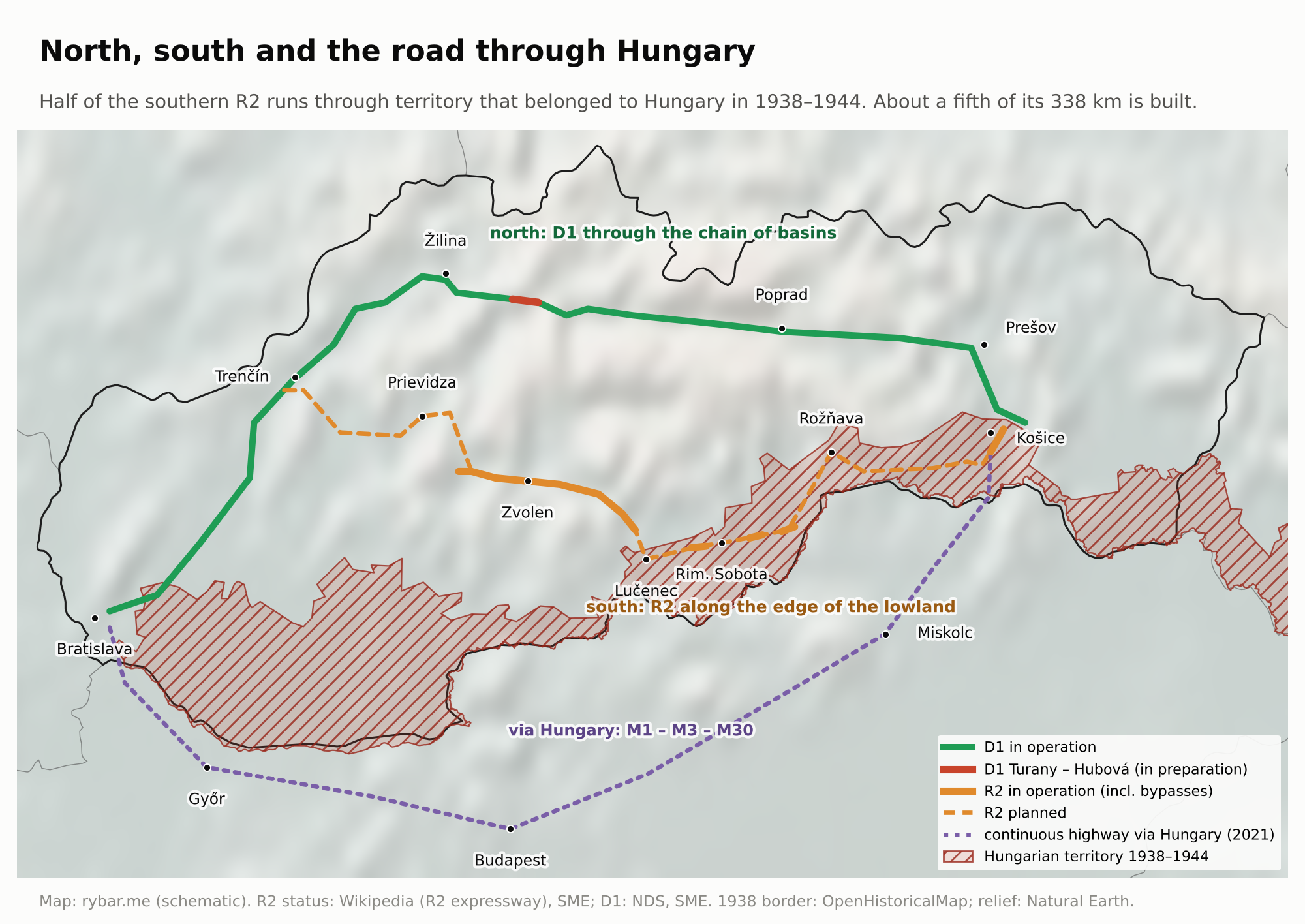
A century of changing states
In thirty years, from 1918 to 1948, five regimes followed one another in Slovakia: Hungarian, Czechoslovak, the People’s Party regime, restored Czechoslovak and communist. Each demanded loyalty, and each punished loyalty to the one before. This can be shown with a single village. Suchá Hora in upper Orava belonged to Hungary until 1918, went to Poland in 1920, to Czechoslovakia in 1924, to Poland again in November 1938, to the Slovak State in 1939, to Czechoslovakia in 1945, and has been in the Slovak Republic since 1993. A grandmother born there before World War I who lived to 1993 had her state changed six times without ever leaving the village.
There is a similar story in the south. The village of Slemence near Uzhhorod belonged to Hungary until 1920, then to Czechoslovakia, and from 1938 to 1944 to Hungary again. On the night of August 30, 1946, the Red Army split it: the larger part, Veľké Slemence, remained in Czechoslovakia and has been in Slovakia since 1993; the smaller, Malé Slemence, went to the Soviet Union and is in Ukraine today. Its oldest residents thus lived in four different states without moving, and families from two ends of one street could visit each other only in 2005, when a pedestrian crossing was opened there.
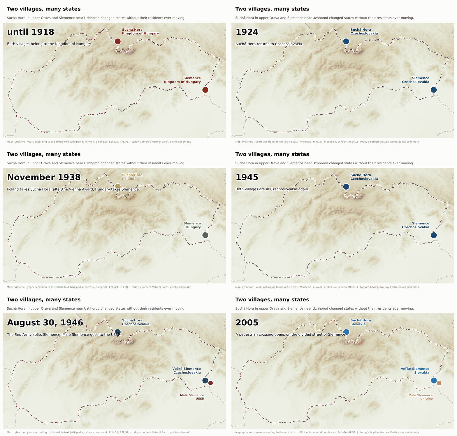
Alongside the states, the country itself changed. Slovakia, a mostly agricultural country in 1945, industrialized within forty years. The arms factories in the Váh valley, the aluminum plant in Žiar, the steelworks in Košice and the chemical plants in the east were built with a clear aim of leveling the two parts of the state, and by 1989 this had largely succeeded. People moved from villages to cities, and for the first time in history the cities became Slovak. A nation that was rural in 1918 had its own engineers, doctors, generals and filmmakers two generations later.
Juraj Buzalka has a word for this generation and its children: post-peasants. In his 2023 book of essays, Postsedliaci. Slovenský ľudový protest (Post-Peasants: Slovak Popular Protest), he describes a person who travels the world with an iPhone and yet believes in a mythologized agrarian home; in his view, most citizens of Slovakia are post-socialist Europeans with ties to the countryside. The author of this text knows it from his own life: as a little boy he helped his parents in the fields at home, and today he is a manager at an international IT company.
To sum up, the 20th century changed the territory of Slovakia faster than the previous thousand years. The country passed through seven state formations: Hungary, the First Czechoslovak Republic, autonomous Slovakia within the Czecho-Slovak Republic, the wartime Slovak State, restored Czechoslovakia, the federation and finally the independent Slovak Republic. The population rose from about three million in the 1921 census to almost 5.4 million in 2001. A nation of peasants became a nation of workers, clerks and university graduates. Yet the borders, apart from 1938 to 1945, barely changed. It was the states around the people that changed, not the people.

Coat of arms, flag and anthem: borrowed and recolored
Slovakia’s state symbols tell the same story as this whole article. Nothing in them is originally Slovak, and everything in them is about mountains.
The double cross. A cross with two crossbars is Byzantine. It was brought to Hungary at the end of the 12th century by King Béla III, who grew up at the imperial court in Constantinople, and it appears on his coins. It became a sign of royal power and later one half of the Hungarian coat of arms. The explanation that Cyril and Methodius brought it is more recent. But it fits nicely: a cross from the East on the shield of a kingdom that belonged to the West.


Three hills. The triple mount under the cross appears on a seal from 1305 and became established in the 14th century. From the 16th century it was explained as Hungary’s three mountain ranges: the Tatra, the Mátra and the Fatra. Two of them are in Slovakia. The Mátra lies in today’s Hungary. The Slovak coat of arms thus shows a mountain range that doesn’t belong to Slovakia, and no one minds, because the coat of arms was not created as a map of Slovakia but as an image of Upper Hungary.
The colors. In the Hungarian coat of arms, the hills are green. In the revolutionary year of 1848, Slovaks recolored them blue so that the coat of arms would have the Slavic colors: white, blue and red. The Slovak coat of arms is thus the right half of the Hungarian one in different colors. Hungary still has the same half in its coat of arms today: a silver double cross on three green hills, topped with a small crown. Two neighboring states that argued over history for a hundred years have the same cross on the same hills in their coats of arms.


The least known is the coat of arms from 1960 to 1990. In it, communist Czechoslovakia replaced the double cross, which recalled both Hungary and the church, with the silhouette of Kriváň and a partisan bonfire, a reference to the uprising. Paradoxically, it was the most Slovak coat of arms Slovakia ever had: the only one that showed not half of the Hungarian arms but a Slovak mountain.


The flag. In 1848 the Slovaks borrowed the tricolor from Russia, as did the Serbs, Croats and Slovenes. When they needed a flag for an independent state in 1992, they found that Russia already had the same white-blue-red one, and Slovenia almost the same. That is why, since September 3, 1992, it also carries the coat of arms.
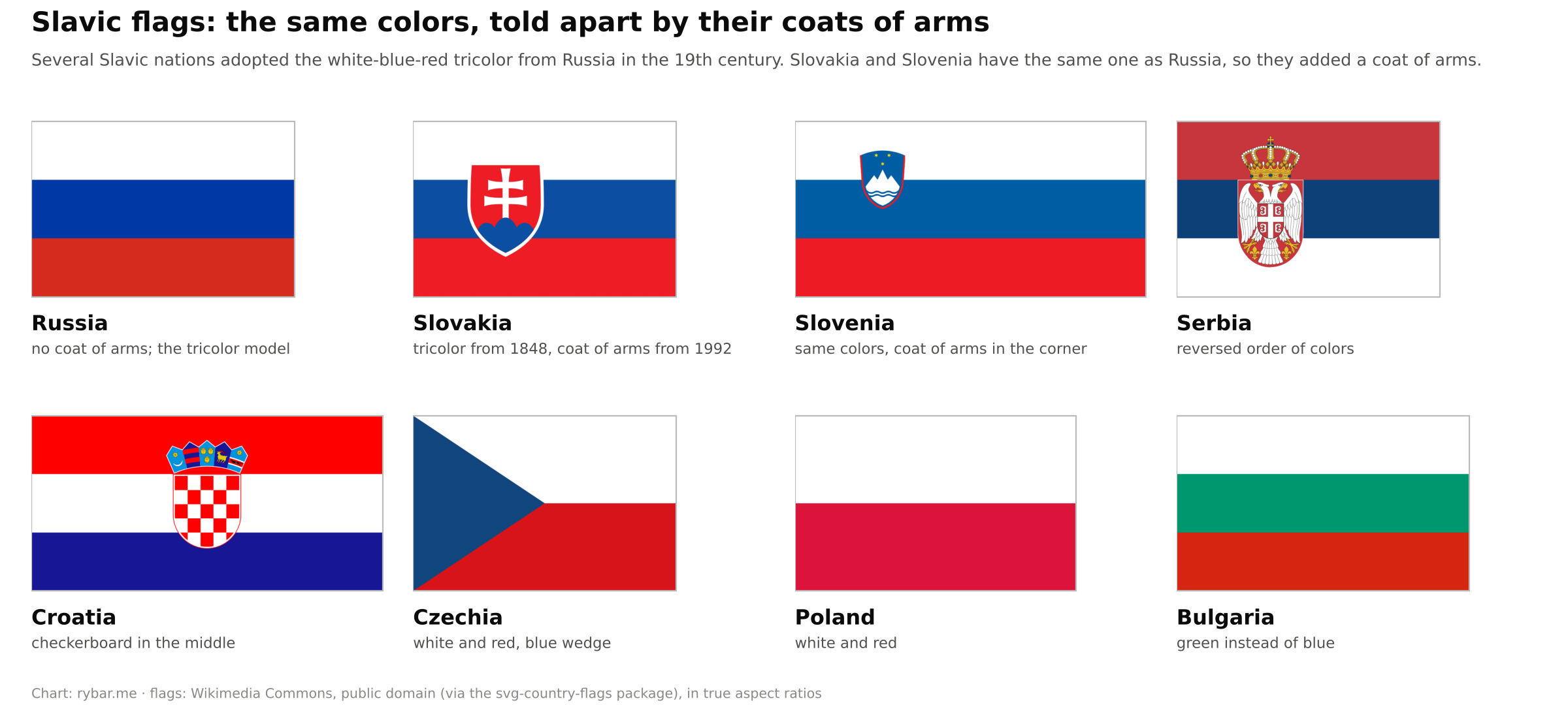
The anthem. Nad Tatrou sa blýska (Lightning over the Tatras) was written in 1844 by the student Janko Matúška to the tune of the folk song Kopala studienku, when students of the Bratislava lyceum were leaving for Levoča in protest against Štúr’s dismissal. From 1918 to 1992 it was the second half of the Czechoslovak anthem, right after the Czech Kde domov můj. It begins with a storm over the Tatras.
Kriváň. The first national outing to its summit was led on August 16, 1841, by Ľudovít Štúr and Michal Miloslav Hodža. When Slovaks chose the designs for their euro coins in a 2005 poll, the double cross, Kriváň and Bratislava Castle won. Two of the three symbols are mountains; there is neither a river nor a lowland among them.
Heroes and myths
Every nation needs a story about itself. Nations with kings have battles and coronations. A nation that had no state, no nobility and no army had to choose its heroes differently, and that choice says a lot about it. Slovak historians and ethnologists analyzed it in the 2005 book Mýty naše slovenské (Our Slovak Myths), and in 2019 viewers of the public broadcaster RTVS confirmed it in the poll The Greatest Slovak.
Cyril and Methodius. In the 2019 poll, Cyril and Methodius also made the top ten, as a single pair. It’s a paradox: they were not Slovaks and did not even come from this territory. They were Byzantine brothers from Thessaloniki and came to Great Moravia at Rastislav’s invitation, as we have seen. Critics pointed this out after the poll. For Slovaks, however, they symbolize what remained of Great Moravia: a script and a language allowed into church. The paradox is all the greater because their work ultimately lost here. As we have seen, Methodius’s disciples were expelled, Slovakia became part of the Western, Latin church, and today it is mainly the Orthodox Slavs who directly continue the Cyrillo-Methodian tradition. Here, what remained of it is mostly a symbol.
Great Moravia and the “Old Slovaks.” The national revivalists of the 18th and 19th centuries needed to prove that Slovaks had a history, and Great Moravia was the only state they could claim. Today it is in the preamble of the constitution, which invokes the Cyrillo-Methodian spiritual heritage and the historical legacy of Great Moravia, and July 5 is a public holiday. The problem arises when heritage turns into ownership. In 2008 Prime Minister Robert Fico began speaking of the “Old Slovaks,” and in June 2010, a week before the election, an equestrian statue inscribed “Svätopluk, King of the Old Slovaks” was unveiled in the courtyard of Bratislava Castle. A commission of historians convened by the new speaker of parliament called the inscription misleading, and it was removed in November 2010. The shield was also altered; it had carried an equal-armed double cross resembling the emblem of the Hlinka Guard.
What is true about it? Svätopluk was a real and powerful ruler. The sources call him king, but not all of them. In 880 Pope John VIII addressed him as comes, that is, prince or ruler. In 885 Pope Stephen V wrote to him as “king of the Slavs,” rex Sclavorum, and the chronicler Regino of Prüm also calls him king. The Frankish annals write dux. He was not a crowned king in the sense that Stephen I was a hundred years later. His subjects were called Sloveni or Moravians and are the ancestors of Slovaks, Moravians and some Hungarians. And according to historians, he was probably never at Bratislava Castle.
Three rods and a white horse. Two legends are told about Svätopluk, and each belongs to a different nation. According to the first, recorded by the Byzantine emperor Constantine Porphyrogenitus, the dying ruler gave his sons a bundle of three rods so they would understand that together no one could break them. Slovaks turned it into an image of unity. The second comes from Hungarian chronicles: Svätopluk supposedly sold the land to the Hungarians for a white horse, a saddle and a bridle. From this legend it was later argued that Slovaks were descendants of those who sold the land and therefore did not have equal rights in Hungary. That is exactly what Michal Bencsik, a professor of Hungarian law at the University of Trnava, wrote in 1722. A reply came out in Púchov in 1728 in a pamphlet known as the Apologia and attributed to Ján Baltazár Magin, the parish priest of Dubnica: in his view, Slovaks had lived in the land since time immemorial and were its rightful inhabitants. It is considered the first printed defense of the Slovaks.
Matthew Csák. The Romantics also looked for a Slovak ruler and found him in Matthew Csák of Trenčín. He was the most powerful of the Hungarian oligarchs of the early 14th century: his estates lay in fourteen counties and included sixty castle domains, fifty of them in today’s Slovakia. But he was neither a Slovak nor a Slavic ruler: his family came from Transdanubia, and historians describe him as a Hungarian oligarch. We found no evidence that he identified with the Slavs. From the 18th century Slovak patriots made him an uncrowned Slovak king, and Štúr’s circle saw him as a national hero. The book Mýty naše slovenské devotes a separate chapter to this image.
Jánošík. The only hero every child knows is an outlaw. Juraj Jánošík was born in 1688 in Terchová, was a soldier and a prison guard, robbed for about a year and a half, and was executed in Liptovský Mikuláš in March 1713. Štúr’s generation of poets turned a local criminal into a national hero: he took from the rich and gave to the poor, and bowed to no lord. The first Slovak feature film, from 1921, financed by American Slovaks, is about Jánošík. That a nation chose an outlaw from the mountains as its symbol rather than a king or a general fits a nation that describes itself as plebeian. The Poles claim Jánošík too. In Poland’s Podhale region he became a folk hero thanks to the writer Kazimierz Tetmajer and Jerzy Passendorfer’s 1974 TV series, although according to the Lesser Poland tourist board he almost certainly never set foot on Polish territory. An English-speaking reader will recognize Robin Hood in him, but there is a difference. Robin Hood’s existence has never been proven: the first mention is in the poem Piers Plowman from around 1377, the oldest ballads are from the 15th century, and the name Robehod appears in 13th-century court records as a nickname for outlaws. Jánošík is a documented person, baptized on January 25, 1688, and executed on March 17, 1713. What they share is that the real outlaw matters less than the legend that poets made of him centuries later.
A dove-like nation. From Herder and Kollár comes the image of the Slavs as peaceful, hardworking, singing people who never attacked anyone. History does not bear this image out. The Slovak army took part in the attack on Poland in September 1939 and fought against the Soviet Union from June 24, 1941. The wartime state deported its own Jews and, from 1941, sent Roma to labor units, for example in Hanušovce nad Topľou, Dubnica nad Váhom and Ilava; in November 1944 a detention camp for Roma was set up in Dubnica. And before that, Slovaks fought for centuries in the wars of Hungary and the Habsburg monarchy, like the hussar Škultéty, whom we have already met.
A thousand years of bondage. The idea that Slovaks suffered under the Hungarian yoke for a thousand years arose in the 19th century as a mirror image of Magyarization. Historians count it among the myths. Hungary’s official language was Latin until 1844, the Hungarian political nation consisted of the nobility regardless of language, and the Magyarization laws came only in the second half of the 19th century.
Štúr and Štefánik. In the 2019 poll, Milan Rastislav Štefánik won ahead of Ľudovít Štúr and the priest Anton Srholec. The top ten also included Cyril and Methodius, Jánošík, Hlinka, Dubček, Husák, the paratrooper Jozef Gabčík and the cyclist Peter Sagan. Štefánik has everything a hero needs: humble origins, a world-spanning career, a uniform and a tragic death. His plane crashed near Bratislava on May 4, 1919, as he was returning home. It is telling that Slovaks regard as the founder of their state a man who founded Czechoslovakia, not independent Slovakia.
The uprising. The Slovak National Uprising is the only case in modern history when Slovaks fought on a large scale for a cause they chose themselves. That is why August 29 is a public holiday, and why every regime has fought over its interpretation. The communists appropriated it; defenders of the wartime state still call it a putsch.
The uprising was led by Generals Ján Golian and Rudolf Viest. Both were captured on November 3, 1944, in Pohronský Bukovec, sentenced in Berlin, and probably died in Flossenbürg in 1945. The communist interpretation pushed them into the background and put the partisans and the Soviet army in front. Historian Jozef Jablonický, whose research showed the army’s role in the uprising, was persecuted by the StB secret police during normalization. The names of the insurgent generals have returned to public memory only in recent decades.
The list is short, with few victories in it. Priests, poets, one outlaw, one general of a foreign army and one lost uprising. For a mountain nation that had no state of its own for a thousand years, it is an accurate picture.

What is missing from the map is interesting too. Slovak heroes and myths cluster in the northwest and the central mountains, the regions where the national movement was born. In the east and the south we found almost nothing. Not because no one lived there, but because the heroes there belong to another story. Since 1906, Francis II Rákóczi and his companions, leaders of an anti-Habsburg uprising, have rested in St. Elisabeth Cathedral in Košice, and Imre Thököly was buried in Kežmarok the same year. For Hungarians they are national heroes, and after 1918 their memorial sites ended up in another state. The south, with its large Hungarian population, remembers mainly Hungarian figures. The map of Slovak heroes is thus also a map of where the Slovak national story was told.
Slovakia and Slovenia: the two that kept the original name
Let’s return to the name. We saw that the Slavs called themselves Slověne. Over time most tribes found a narrower name: Czechs, Poles, Serbs, Croats, Russians. A few groups on the edges of the Slavic world kept the original one. The Ilmen Slavs near Novgorod, the Slovenes in the Alps and the Slovaks in the Carpathians.
That’s why the names of these two countries are so similar. Slovenka means a woman from Slovakia in Slovak and a woman from Slovenia in Slovene. “Slovenský jazyk” and “slovenski jezik” are two different languages. Slovakia in Slovene is Slovaška; Slovenia in Slovene is Slovenija. The masculine form Slovák is more recent. It has been in common use in Slovak texts since the 15th century and replaced the older form Sloven or Slovenin. The feminine form and the adjective stayed original.
The similarity doesn’t end with the name. Both countries, as we’ve seen, have a white-blue-red tricolor from 1848, and both had to add a coat of arms to it so they could be told apart. Both lie on the mountainous rim of the Pannonian Basin, one on the Alpine side, the other on the Carpathian. Both were part of the Habsburg monarchy for centuries, the Slovenes in the Austrian half, the Slovaks in the Hungarian. Both nations grew out of a language, not a state: the Slovenes had their Štúr in the poet Prešeren and their 1848 in the United Slovenia program. In 1918 both joined a larger Slavic brother, the Slovenes the Serbs in Yugoslavia, the Slovaks the Czechs. Both became republics in a federation, and both left it in the early 1990s, the Slovenes after a ten-day war, the Slovaks without a shot. And both joined the European Union and NATO in 2004.
The result is that the world confuses them. At the beginning of the millennium, according to the prime ministers of both countries, about 5,000 shipments meant for Slovenia ended up in Slovakia in a single year. In 1999, during his presidential campaign, George W. Bush told a Slovak journalist about meeting Slovakia’s foreign minister, when in fact he had met Slovenia’s prime minister. The well-known story that the staff of the two embassies swap mail once a month is mostly legend. It goes back to a single anonymous sentence by a Slovenian ambassador in The New York Times in 2004, and the embassies in Washington denied it in 2017.
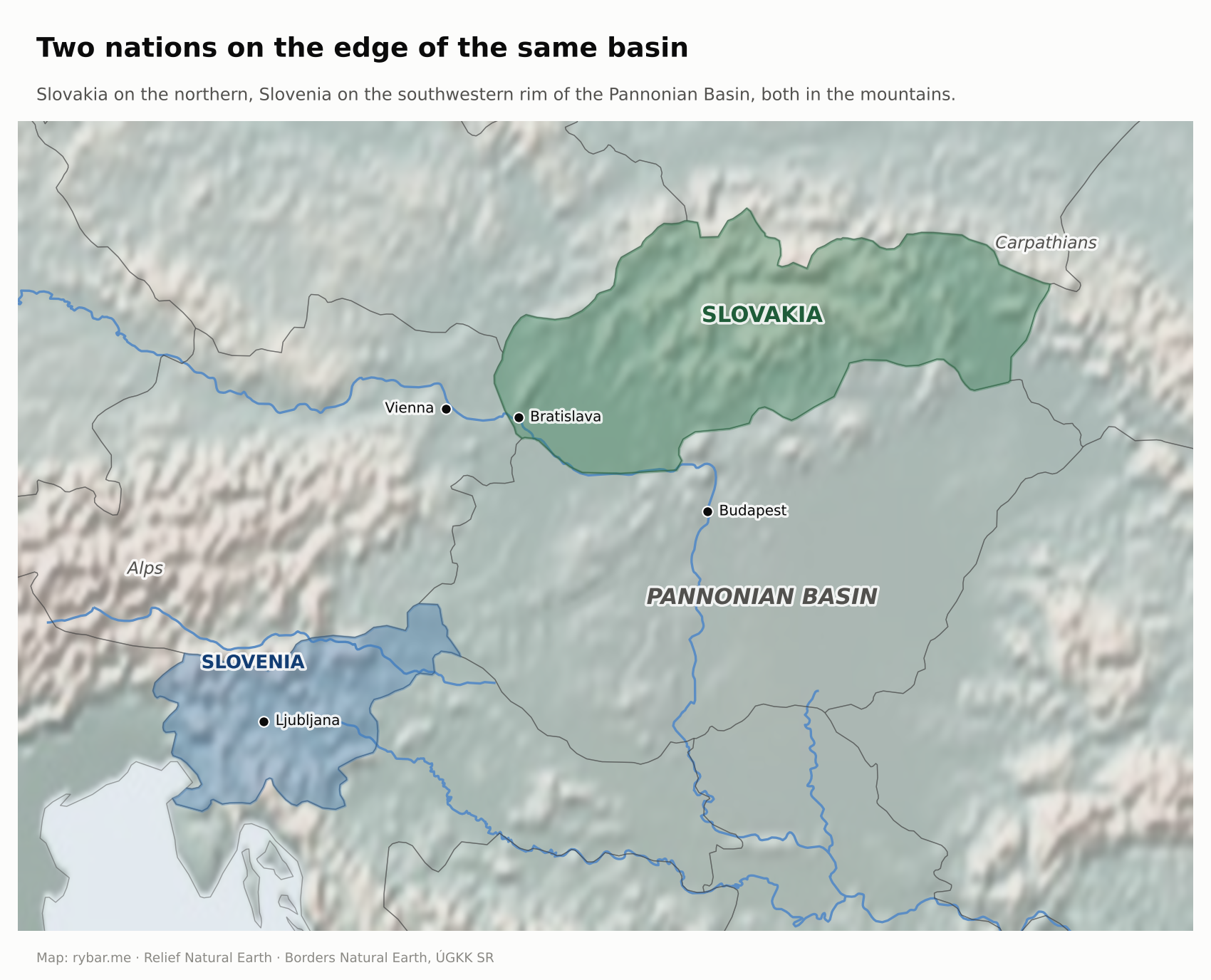
This is no accident but the same geography. Until the Hungarian wedge formed in Pannonia in the 10th century, the Slavs formed a continuous belt from the Alps to the Carpathians, and Central Slovak still carries a trace of that link. Then two groups were left on two mountainous rims of the same basin, each under a different half of the same empire. The mountains preserved both their language and their name, and kept both from growing. Slovenia is the closest answer to the question of what Slovakia would look like if it lay by the sea.
West, east, or a bridge?
One metaphor has kept returning to Slovak politics since the 19th century: Slovakia as a bridge between East and West. Today’s government speaks of a foreign policy facing “all four points of the compass.” To understand where this comes from, we have to look at the map again.
For two thousand years the territory of Slovakia lay on the border between blocs. The Danube was the border of the Roman Empire. In the 9th century Frankish and Byzantine influences met here. In the 16th and 17th centuries the border between the Habsburgs and the Ottomans ran through here. From 1948 to 1989 Bratislava was within sight of the Iron Curtain. Today Slovakia’s eastern border is the border of the European Union and NATO. A country on the edge always has two neighbors it has to get along with.

The eastern direction has its roots in the 19th century. A nation without a state and without allies looked for support and found it in the only free Slavic state, Russia. Kollár dreamed of Slavic reciprocity. Štúr, disillusioned by 1849, wrote in German a treatise, Slavdom and the World of the Future. In it he argued that the West was decaying and that the Slavs had a future only at Russia’s side. It came out only after his death, in 1867 in Moscow, in Russian translation. Experience added to this: Russian troops defeated the Hungarians in 1849 and liberated Slovakia from the Nazis in 1945.
The western direction is older and deeper, just less conspicuous. Latin Christianity, the Latin alphabet, Gothic architecture, German town law, the universities in Vienna and Prague, the Reformation. Everything that made the Slovaks what they are came from the west. The republic of 1918 was pushed through by the French, the British and the Americans. And the tanks that ended the Prague Spring in August 1968 came from the east. People also voted with their feet, mostly westward: hundreds of thousands of Slovaks left for America before World War I, while about twenty thousand went east in the 20th century, many of them involuntarily.
A bridge was already Edvard Beneš’s plan. Czechoslovakia had had an alliance treaty with the Soviet Union since 1935. After the experience of Munich, Beneš signed a new one in Moscow on December 12, 1943, while hoping that Czechoslovakia would be a bridge between East and West. It ended with February 1948. Since then the metaphor has returned several times. In the 1990s Vladimír Mečiar spoke of Slovakia as a bridge between East and West. In 1997 Slovakia was the only Visegrád Four country left out of the first wave of enlargement. U.S. Secretary of State Madeleine Albright then spoke of a hole on the map of Europe, and the label “black hole of Europe” caught on. The 1998 election turned the direction around. In 2004 Slovakia joined NATO and the EU, in 2007 Schengen, and in 2009 it adopted the euro as the first Visegrád Four country. After eleven centuries, what had been decided by the dispute between Methodius and Wiching was confirmed again: Slovakia belongs to the Latin West. The paradox remains, as we saw with the heroes, that it is the brothers from Thessaloniki who stand in the preamble of the constitution.
Public opinion has been steadily split ever since. In the 2017 GLOBSEC Trends survey, 42% of Slovaks said the country should stand somewhere between East and West. In 2025, 75% of respondents supported EU membership and 72% NATO membership, while 32% called Russia a strategic partner. Only 49% would be willing to defend the country with a weapon in hand, the lowest of the nine countries surveyed. In Poland it was 84%.
There are differences between regions too. In an AKO poll for JOJ 24 in June 2025, 65% of people in the Bratislava Region were against neutrality, but only 40% in the Prešov Region, where just as many supported it.
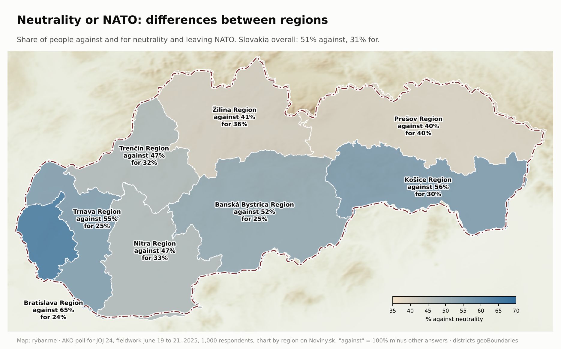
The map shows geography too. Support for neutrality was highest in the mountainous Prešov (40%) and Žilina (36%) regions, and lowest in Bratislava (24%) and on the plain in the Trnava Region (25%). The north and east, far from Vienna and the western borders, lean more toward neutrality than the west and south. But it isn’t a rule: the mountainous Banská Bystrica Region has as few supporters of neutrality as Trnava (25%). This is where the Slovak National Uprising began in August 1944, and the mountains around Banská Bystrica served not as a refuge from the world but as a fortress from which part of the army and the resistance sided with the Allies against Germany. A region that still claims the memory of armed resistance may therefore understand security more as alliance than as standing apart.
It is tempting to read this as the legacy of the history we have just gone through. A nation that grew out of a language rather than a state, that mostly got its states when the great powers came to terms, and whose heroes are poets and an outlaw, has a more cautious relationship to the state and its defense than a nation that fought for its state. But that is an interpretation, not a proven fact, and polls change faster than geography.
The Visegrád Four
Slovakia gave one answer to the question of where it belongs together with its neighbors, and that answer, too, has roots in geography. In November 1335, King John of Luxembourg of Bohemia, Charles Robert of Hungary and Casimir III of Poland met at Visegrád. They agreed on trade routes that would bypass Vienna and its staple right: goods from Hungary were to go through Brno to Bohemia and on to Germany. Vienna sat on the Danube, on the main road from the basin to the west, and the detour went overland through Trnava and Brno. John gave up his claims to the Polish crown, and Casimir recognized that Silesia belonged to the Bohemian Crown. Three kingdoms lying east of the Alps, between Germany and the steppe, were looking for a way west that didn’t pass through someone else’s tolls.
Václav Havel, Lech Wałęsa and József Antall referred to that place too when they signed a declaration of cooperation at Visegrád on February 15, 1991. After Czechoslovakia split in January 1993, the three became four. All four countries joined the European Union on May 1, 2004, and the International Visegrad Fund, founded in 2000, is based in Bratislava. The goal is similar to that of 1335: to have a road of their own to the west and a common voice.
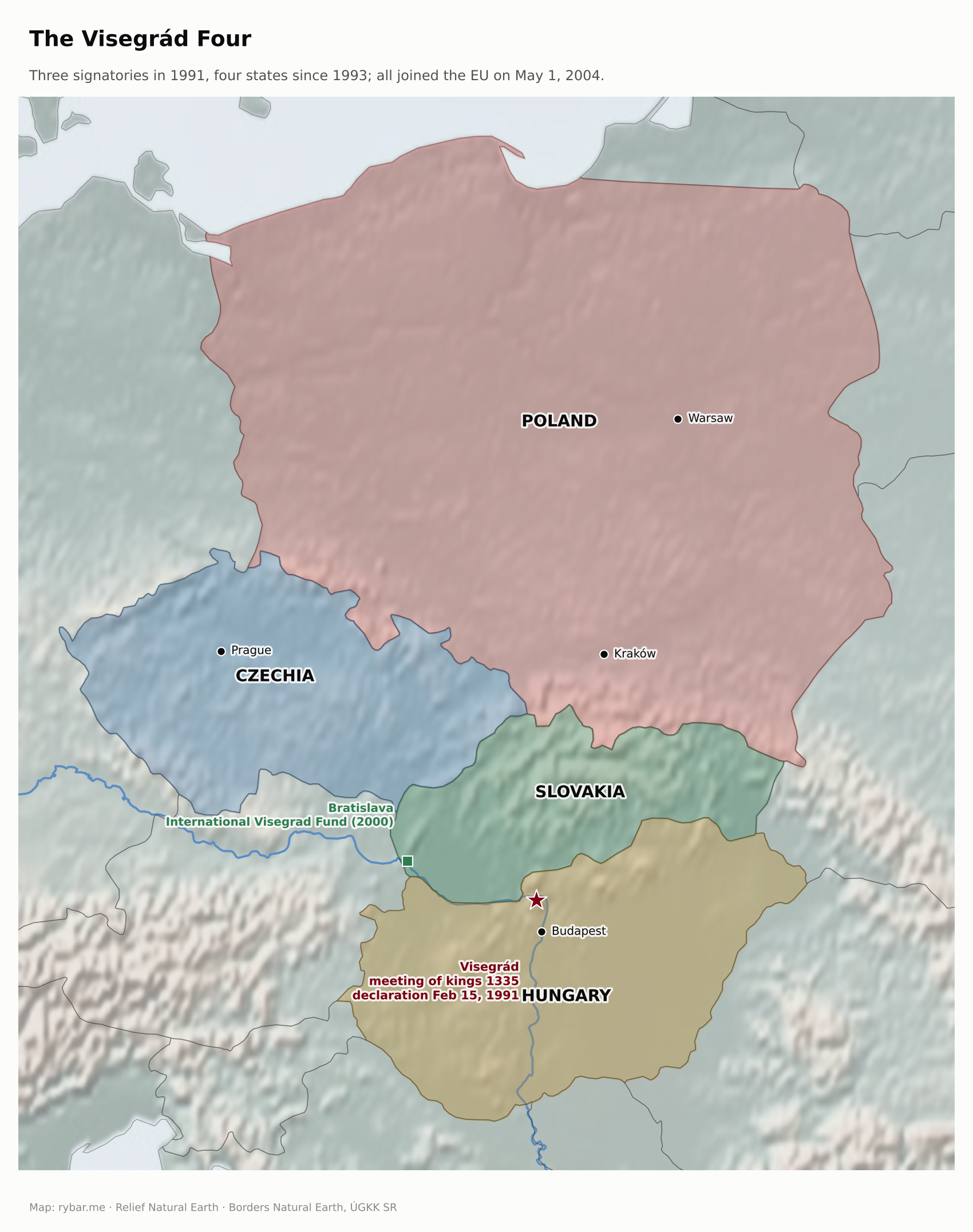
From the start, the Four’s main common goal was joining the European Union. For Slovakia it was not a given, and it was a close call. Because Slovakia was left out of the first group of candidates in 1997, accession talks began only after the 1998 election, in February 2000, and Slovakia had to catch up in two years with neighbors who had been negotiating longer. The May 2003 referendum was valid by a hair: 52.15% of voters took part, with a validity threshold of 50%, and 92.46% of them voted for accession. It was the first valid referendum in the country’s history.
Here, for the first time in this story, politics mattered more than geography. Slovakia and Slovenia also have mountain Slavic relatives in the Balkans: Serbia, Bosnia and Herzegovina, Montenegro and North Macedonia. All are small Slavic countries that broke away from federations in the early 1990s. According to the World Bank, Slovakia’s GDP per capita at purchasing power parity was $11,400 in 2000 and Serbia’s $6,400. In 2024 it was $47,800 and $32,800. Location plays its part: Slovakia lies within sight of Vienna and close to German factories, Serbia in the Balkans with no border with the Union’s core. But Serbia grew fast, and still the per-person gap tripled. The mountains are similar; the difference was made mainly by the Union, which one got into and the other is still waiting outside.
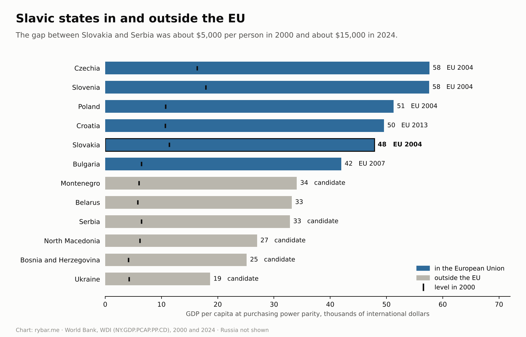
Mountains and plain in the election maps
Geography can also be read from election results. When we look at them by municipality, they don’t look like a random mosaic. Their borders follow the old regions, the language border and the 1938 border.
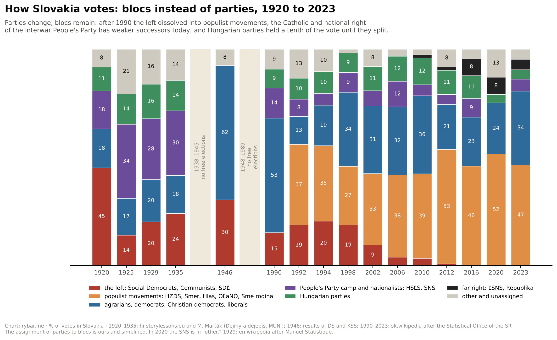
In the 2023 parliamentary election, Smer-SD won in most municipalities and in every region except Bratislava, where Progressive Slovakia won. The Alliance party won in 383 municipalities, and according to our map, 377 of them lie in the territory Slovakia lost to the Vienna Award in 1938. The language border that formed on the edge of the basin is still visible in elections today.
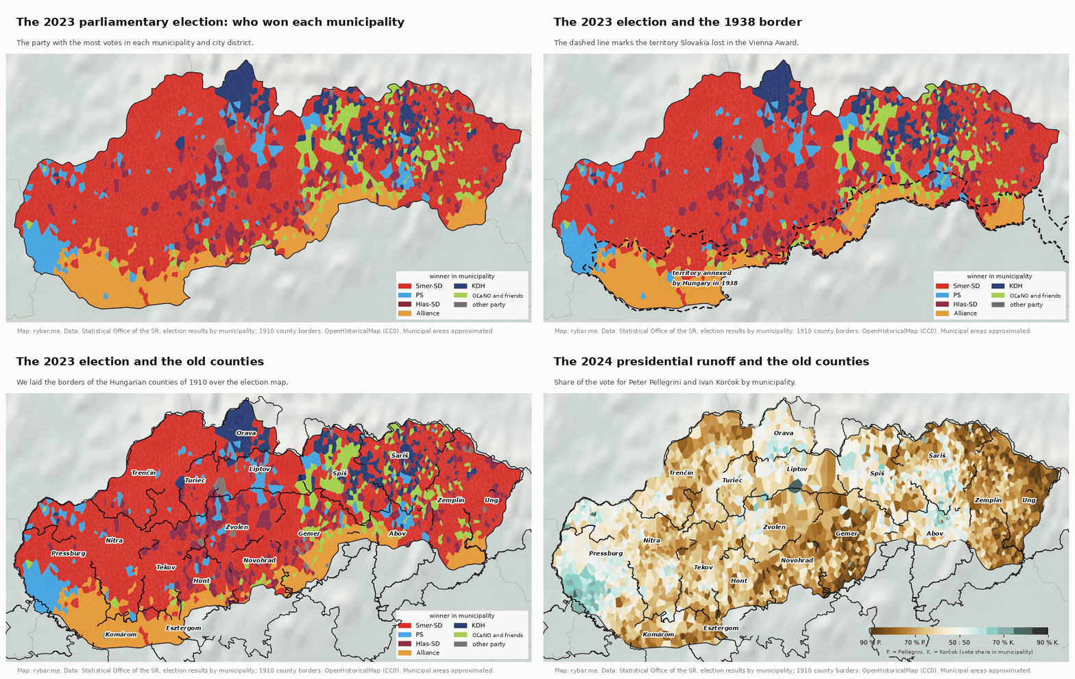
Other borders are even older. In Orava, for centuries a separate county beyond the ridges, the Christian Democrats (KDH) won in many municipalities, and similarly in parts of Šariš and Spiš. These are the regions where the Catholic Church is strongest, as the map of religion showed. The election map of the east is much more varied than that of the west, just like its dialects.
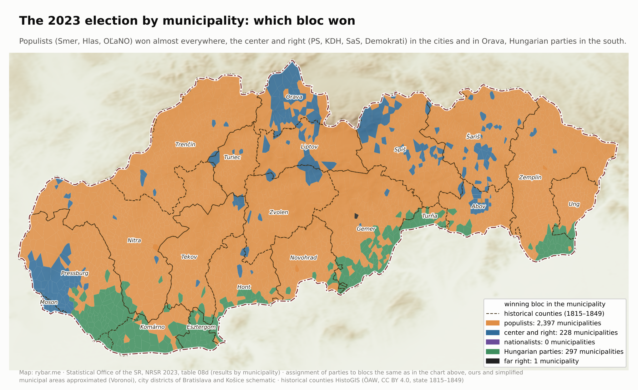
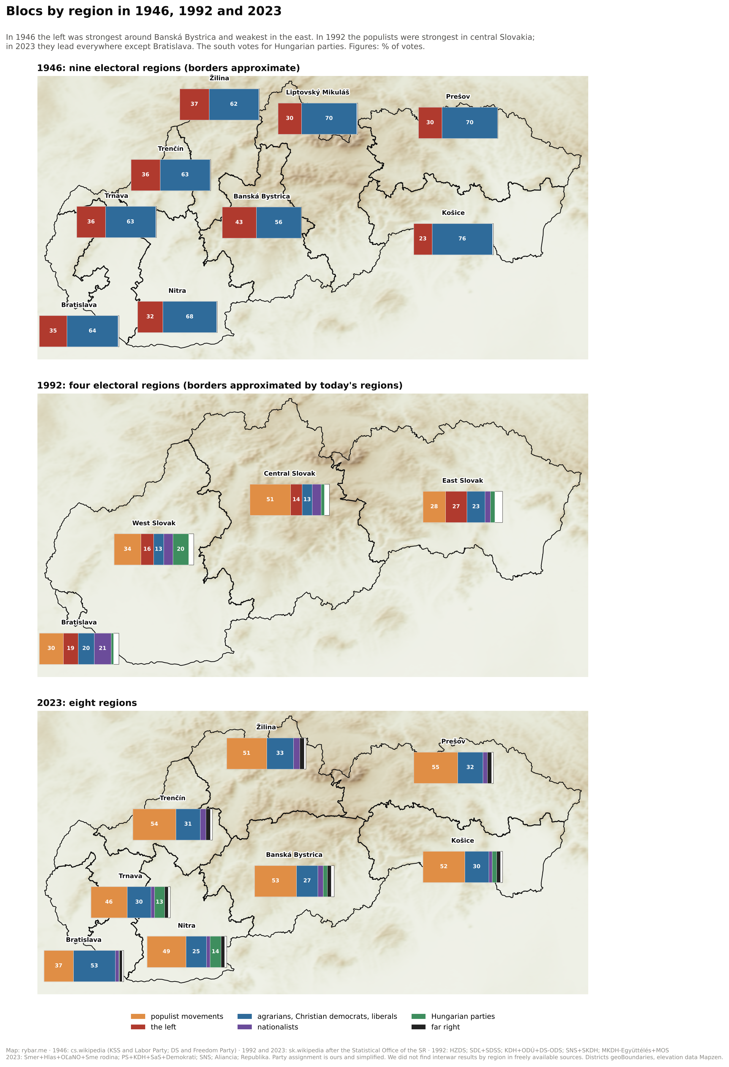
Peter Pellegrini won the second round of the 2024 presidential election. Ivan Korčok won 46.9% of the vote in Slovakia as a whole, 66% in the Bratislava Region and almost 60% in Košice. In large towns with more than 15,000 voters he averaged 58%, in small municipalities only about 39%. The gap between the metropolis on the plain and the rest of the country, and between town and countryside, is thus visible in both elections.
The southern border visible in the elections is still a political issue too. On the anniversary of Trianon, June 4, 2026, Hungarian Prime Minister Péter Magyar said that Hungary is the only country that borders itself. The Slovak foreign ministry replied that the borders were set by Trianon and confirmed by the peace treaties after World War II. Both sentences speak of the same line on the edge of the lowland, each from a different side.
Family and friends instead of the state
Everything we have gone through also says something about how Slovaks behave today. A nation whose states changed over its head had to find another anchor.
It is often said that every Slovak family had at least one partisan and at least one Guardsman. Peter Karvaš’s play Polnočná omša (Midnight Mass), filmed by Jiří Krejčík in 1962, is built on that image: on Christmas Eve 1944, four children gather at the home of their parents, the Kubiš family: a collaborator, a Guardsman, a partisan, and a daughter who is the mistress of the German commander.
In a small country where everyone knows everyone through the village, the parish or a brother-in-law, people learned to rely more on family and acquaintances than on the state, which would change again in a few years anyway. The best-known example is the friendship between the communist poet Laco Novomeský and Alexander Mach, the interior minister of the wartime state. They met around 1925 to 1926, and their friendship lasted through the Slovak State. In 1941 Novomeský’s interventions led to the release of several detained communists; in 1947 Novomeský testified in Mach’s favor in court; and after Mach was released in 1968, the two talked for six hours in Bratislava. Gustáv Husák did not know Mach personally before or during the war, but in 1956 they shared a prison cell.
An interpretation suggests itself. The nepotism and clientelism that still plague the country are the flip side of the same coin: loyalty to one’s own is stronger than loyalty to rules. This is an interpretation, not a proven fact, but it fits well with the story of a nation that came into being without a state and against the state.
The mountains that protected, and the plain that came
Looking at a thousand years at once, we can see what the mountains did. Poland’s Bolesław the Brave seized the territory up to the Danube around the turn of the millennium but couldn’t hold it, because the valleys open to the south. Sixteen Spiš towns were pledged to Poland from 1412 to 1772, and yet they remained part of Hungary. The Ottomans never directly ruled the mountainous north. The Russian army crossed the passes in 1849 as Vienna’s ally and left again. In the winter of 1914 to 1915 the Russian offensive stalled in the Carpathians. Hungary lost and gained territory in the south and east, but kept its mountainous north without interruption until 1918. For the Slovaks this had a twofold consequence: no one divided them among several states, and no one tore them out of Hungary.
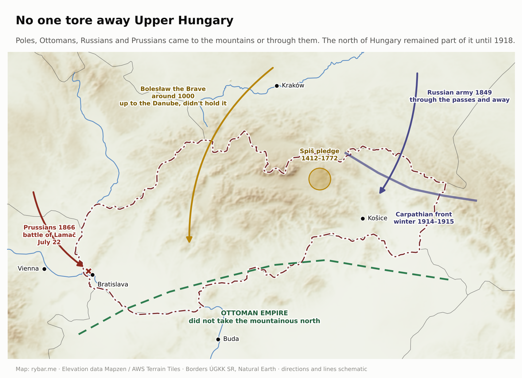
But the mountains only preserved the Slovaks. Remember the map of the small Slavic nations from the beginning. The marshes of the Spree protected the Sorbs in a similar way, and yet they never had a state of their own. A refuge preserves a nation; it doesn’t make a state of it on its own. Slovakia entered the 20th century as a mountain people that didn’t even have a name on the map.
Slovakia came out of the 20th century differently, though. The 1920 border did not follow the language border at the foot of the mountains, but the Danube and the Ipeľ. Slovakia thus got the Danubian Lowland with Rye Island and the East Slovak Lowland, the country’s two most fertile plains. On the right bank of the Danube it got Petržalka, and the 1947 Paris Peace Treaty added Jarovce, Rusovce and Čunovo, 62 km² in total, so that Bratislava could expand its port and regulate the Danube. Bratislava thus lies on both banks of the river, and since 1992, when the Rhine-Main-Danube Canal opened, its port has been connected by waterway to both the North Sea and the Black Sea.
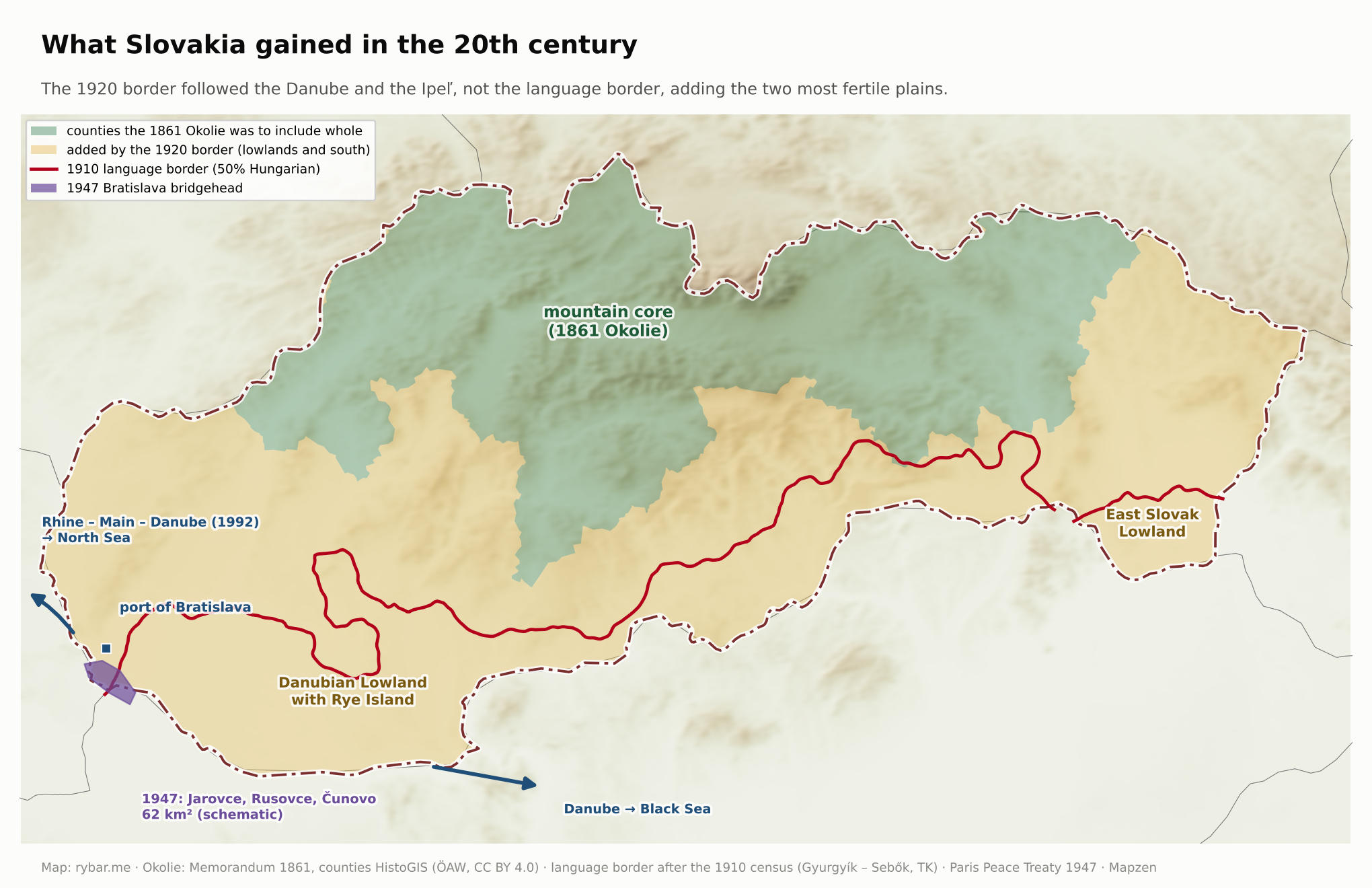
This is our interpretation, not the conclusion of historians: Slovakia won the 20th century. Of everything the Slovaks had in 1900, only the mountains and the language remained. By 2000 they had their own state, two lowlands, a capital on a great river and a port on a waterway across Europe. By 2009 they had added membership in NATO and the European Union, Schengen and the euro, and with them a democracy that Slovaks defended in the 1998 election. The mountains gave them their language and time. The plain, the river and their location can give them wealth, if they make use of them.
For a thousand years the mountains preserved the language of a people without a state, but a state grew out of it only because a monarchy collapsed at the right moment.
The mountains that made Slovakia long and thin and pushed Bratislava to the edge are also the reason it exists at all. They preserved the language when there was nothing else. At the same time, they split the country into valleys that are still coming together today. Slovakia is an example that a nation needs no kings, no victorious battles and no old borders. A language, a few stubborn pastors, teachers and scholars, and enough time will do.
Answers
- Why didn’t nature draw it? Because it is neither a basin nor a river catchment. It is the northern rim of the Pannonian Basin, with mountains in the north and an open plain in the south.
- Where did the Slavs come from? They came from the 6th century onward from the area between the Dniester and the Don, family by family, into a land depopulated by the migration period. Genetics confirmed it in 2025. And there are so many of them because between the 6th and 8th centuries they replaced most of the original population from the Elbe to the Balkans. Today about 300 million people speak Slavic languages.
- Why didn’t they become Hungarians? Because the Hungarians occupied the plain and left the mountains alone, because Hungary was administered in Latin until 1844 and nobody cared what language the subjects spoke, and because half a century of harsh Magyarization after 1867 was too little for two million people scattered in remote mountain valleys, which schools and offices reached last.
- Why didn’t they become Czechs? Because a thousand-year border between two kingdoms and a different natural unit separated them from the Czechs; because the Czechs had a state of their own and the Slovaks did not; because Czech was the written language of the Lutheran minority while the people spoke their own way, and the Czech of the national revival drifted even further from their speech; and because in 1843 Štúr chose a language that both Catholics and Lutherans accepted. Twenty years of a common state then raised a generation that wanted to be itself.
- Why not Moravians, Poles or Rusyns? From the Moravians they were separated by the Morava River as a state border, from the Poles by the Carpathian ridge, from the Rusyns by the Greek Catholic Eastern rite with Cyrillic.
- What is a nation, and how long has the Slovak one existed? According to Anderson, a nation is an imagined community of people who will never all meet and yet feel they belong together. The Slovak one has existed as a people with its own language since the early Middle Ages. As an idea, since 1787 to 1843. As a political program, since 1848. As a mass community aware of itself, only since the 1920s and 1930s.
- Why did a state come into being without a vote? Because the shell of a republic had existed since 1969, the winners of the 1992 elections could not agree on a common state, and there was no territory between Czechs and Slovaks worth fighting over.
- Why do people confuse it with Slovenia? Because both nations, on the mountainous rim of the Pannonian Basin, kept the original name of all the Slavs.
- Why a bridge? Because for two thousand years the land on the edge of the basin was the border between blocs, and a nation without a state looked for support now on one side, now on the other.
Sources
- Origin of the Slavs: Gretzinger et al., Ancient DNA connects large-scale migration with the spread of Slavs, Nature 2025 (nature.com); ELTE summary (btk.elte.hu); Sci.News (sci.news); J. Botík, Etnický obraz Slovenska (is.muni.cz)
- The Hungarian word megye: Wikipedia, Vármegye
- Bencsik and the Apologia: D. Pavličević, review of a book on the Apologia (hrcak.srce.hr); Wikipedia, Ján Baltazár Magin
- Ethnic groups in Czechoslovakia in 1921 by land: J. Němec, Statistiky obyvatelstva meziválečného Československa (is.muni.cz); 1938 borders: historical-basemaps (GitHub)
- Fall 1989 in Central Europe: Wikipedia, Velvet Revolution, Revolutions of 1989
- Population of Slovakia in 2001: Statistical Office of the Slovak Republic, 2001 census (statistics.sk)
- Slovakia in 1997 to 1998 and Albright: The Slovak Spectator, Slovakia’s dance with Russia (spectator.sme.sk); In a black hole – again (spectator.sme.sk); U.S. says Slovakia on right track for NATO, 1999 (spectator.sme.sk)
- Bush and the Slovakia-Slovenia mix-up: The Slovak Spectator 2018 (spectator.sme.sk); Voice of America, November 5, 1999 (globalsecurity.org)
- GLOBSEC Trends 2025: TASR (tasr.sk); SITA (sita.sk)
- Hadik’s raid on Berlin in 1757: Wikipedia, 1757 raid on Berlin
- The Little War of 1939: F. Vrábel, Studia Politica Slovaca 2015 (sav.sk)
- The 2021 census in Czechia: Czech Statistical Office, first results (csu.gov.cz); ethnicity (csu.gov.cz)
- The 1947 Bratislava bridgehead: Wikipedia, Bratislava bridgehead, Rusovce
- The 2024 presidential election by region and town: SITA (sita.sk), Startitup (startitup.sk)
- The ethnonym: Uličný, Latinské etnonymá Slovákov, Historický časopis 2016 (ceeol.com); Marsina, Ethnogenesis of Slovaks, Human Affairs 1997 (ceeol.com); Wikipedia, Slav (ethnonym), List of early Slavic peoples
- Slovakia and Slovenia: BBC 2018, Slovenia, Slovakia, and the constant confusion (bbc.com); WTOP 2017 (wtop.com); The Week, Identity crisis (theweek.com); Slovenia: The Slovenia Times, Slovenia’s Road to Independence (sloveniatimes.com); Britannica, History of Slovenia
- Great Moravia, Industriae tuae, Svätopluk’s titles: Čaky, Politický význam pápežskej buly Industriae tuae (sav.sk); Havlíková, Constantine’s Letters 2015 (ukf.sk); Wikipedia, Great Moravia, Principality of Nitra; Britannica, Great Moravia
- The Svätopluk statue: Wikipedia, Statue of Svätopluk; ČT24 (ct24.cz); Noviny.sk 2010 (noviny.sk); The Slovak Spectator 2010 (spectator.sme.sk); Seznam Zprávy (seznamzpravy.cz)
- Hungary, the share of Hungarians, language laws: Britannica, Hungary: The nationalities (britannica.com); Wikipedia, Magyarization; Hungarian Conservative, the 1844 law (hungarianconservative.com); Britannica, Nationalities Law; Wikipedia, Sándor Petőfi, Lajos Kossuth
- Theory of the nation: Hroch, Why did they win? (journalbelgianhistory.be); V. Gluchman, The 19th-century Slovak National Movement, Nationalities Papers (cambridge.org); E. Gellner, Nations and Nationalism; B. Anderson, Imagined Communities; Wikipedia, Eugen Weber, Miroslav Hroch, Declaration of the Rights of Man and of the Citizen, Henri Grégoire; Encyclopedia of Romantic Nationalism in Europe, Herder and Kollár (ernie.uva.nl)
- The 1900 and 1910 censuses: Human Affairs 1993 (degruyterbrill.com); Žudel, Geografický časopis 1994 (sav.sk); the Apponyi laws: Historiana / hi-storylessons (hi-storylessons.eu); Britannica, Albert Apponyi
- The 1921 census: Wikipedia, Ethnic minorities in Czechoslovakia; Czech Statistical Office, Národnosti v ČR od roku 1921 (csu.gov.cz)
- The Slovjaks and the Slovak People’s Republic: Wikipedia, Slovjak movement; Slovak People’s Republic
- Moravian ethnicity: Czech Statistical Office, První výsledky Sčítání 2021 (csu.gov.cz); Czech Statistical Office, Československé sčítání lidu 1991 (csu.gov.cz)
- Rusyns in 2021: Statistical Office of the Slovak Republic, 2021 census (scitanie.sk); Rusyn Society (rusynsociety.com)
- Origin of Slovak: Wikipedia, History of the Slovak language (including R. Krajčovič’s theory), Eastern Slovak dialects, Moravian Slovakia, Czech–Slovak languages, A language is a dialect with an army and navy, Polish–Czechoslovak border conflicts; Pukanec, a theory of the origin of Slovak, review in Opera Slavica 2014 (muni.cz); dialects: TASR (teraz.sk)
- The 1946 election: ÚPN (upn.gov.sk)
- The 1992 split: The Slovak Spectator 2018 (spectator.sme.sk); Wikipedia, Dissolution of Czechoslovakia, Hyphen War, 1992 Slovak parliamentary election; Britannica, History of Slovakia; Declaration of Sovereignty: TASR (teraz.sk)
- Myths and heroes: E. Krekovič, E. Mannová, E. Krekovičová (eds.), Mýty naše slovenské, AEP 2005 (uesa.sav.sk; review litcentrum.sk); Wikipedia, Juraj Jánošík; Svätopluk’s rods in literature (cejsh.icm.edu.pl); The Greatest Slovak: The Slovak Spectator 2019 (spectator.sme.sk)
- Štúr, Slavdom and the World of the Future: M. Golema, Roczniki Humanistyczne 1999 (ojs.tnkul.pl); R. Bojničanová, Interlitteraria 2014 (doi.org)
- Foreign policy and polls: GLOBSEC Trends 2025 (globsec.org) and earlier editions (globsec.org); PISM 2024, “To the Four Corners of the World” (pism.pl); IES Lublin 2025 (ies.lublin.pl); The Slovak Spectator, Slovakia’s dance with Russia (spectator.sme.sk); Wikipedia, Third Czechoslovak Republic, Schengen Area; the euro: TASR (teraz.sk)
- Mountains as walls and elections by municipality: Fiľakovo (slovensko.sk); Wikipedia, Uyvar Eyalet; TASR, Nové Zámky (teraz.sk); Turkish raids: Filadelfi, Klaudyán 2011 (cuni.cz); World War I in the Carpathians: VHÚ (vhu.sk), Medzilaborce (e-obce.sk); the uprising and Dukla: SITA (sita.sk), Noviny.sk (noviny.sk), TASR (teraz.sk), Novinky.cz (novinky.cz); the 2023 and 2024 elections: Statistical Office of the Slovak Republic (nrsr2023, prez2024); county borders: OpenHistoricalMap
- The Legions: TASR (teraz.sk); VHÚ, Československé légie – Slováci – Slovensko, 2022 (vhu.sk); Wikipedia, Czechoslovak Legion, Czechoslovak Legion in Italy, Battle of Zborov (1917)
- The soviet republic and the 1919 war: Wikipedia, Hungarian–Czechoslovak War, Hungarian Soviet Republic, Slovak Soviet Republic
- The 10th and 11th centuries, the Avars, Bolesław the Brave, the Spiš pledge: Steinhübel, Štefan I. a Boleslav Chrabrý, Historický časopis (ceeol.com); Britannica, Stephen I; Wikipedia, Avar Wars, Treaty of Lubowla, Union of Uzhhorod
- Religion in 2021: Statistical Office of the Slovak Republic, 2021 census (scitanie.sk); Czechia: Wikipedia, Irreligion in the Czech Republic
- The border with Czechia and the division of property: Treaty on the Common State Border, notice No. 274/1997 Coll. (zakonypreludi.sk); Slovak Interior Ministry, the demarcation process between Slovakia and the Czech Republic (minv.sk); Sidonie: Deník.cz (denik.cz)
- Coat of arms, flag, anthem and euro coins: Wikipedia, Coat of arms of Slovakia, Coat of arms of Hungary, Nad Tatrou sa blýska; Britannica, Flag of Slovakia; anthem: TASR (teraz.sk); National Bank of Slovakia, Slovak sides of the euro coins (nbs.sk)
- Slav and slave: Language Log, Slavs and slaves (languagelog.ldc.upenn.edu); Atlas of Enslavement, Etymology (rosalux-geneva.org)
- Geography: ICPDR, Slovakia (icpdr.org); Britannica, Bohemian Plateau, Czech Republic – Land and Slovakia; Wikipedia, Pannonian Basin
- Place names in Hungary: Daily News Hungary, Balaton (dailynewshungary.com); Hungarian Conservative, Pest (hungarianconservative.com)
- Slavic states and languages: Wikipedia, Slavs; Britannica, Slavic languages
- The Czech kingdom, the Hussites and Jiskra: Wikipedia, Kingdom of Bohemia, Charles IV, Holy Roman Emperor, Hussite Wars, Battle of Trnava (1430), Battle of Ilava, John Jiskra of Brandýs; M. Lysý, Husitské vpády do Uhorska 1428 – 1431 a 1432 – 1435, Historický časopis 55 (2007), No. 3 and 4
- The Reformation and religion: ECAV, Šírenie reformácie v Uhorsku (ecav.sk); Wikipedia, Pentapolitana (Confessio Pentapolitana), Leonard Stöckel, Articular church, The Law Book of Žilina, Biblical Czech language, Matthias Bel, Patent of Toleration, Natio Hungarica, University of Trnava, Andrej Hlinka; coronations: TASR (teraz.sk); Hurban and Hollý: TASR, teraz.sk (1, 2); the 1930 census per a book on Project MUSE (muse.jhu.edu); Religious Minority as a Source of National and State Identity: The Case of Slovakia (journals.sagepub.com); A. Innes, Czechoslovakia: The Short Goodbye (is.muni.cz)
- 1526, White Mountain, the estates’ uprisings: Wikipedia, Battle of Mohács, Battle of White Mountain; review by J. Bartl, Historický časopis (sav.sk); Slovak Scholars in Bohemia and Moravia (uni-lj.si)
- First prints: Wikipedia, Bardejov Catechism, Missale Romanum Glagolitice, Biernat of Lublin, Martynas Mažvydas, Primož Trubar, Magyar Hírmondó, Slovak literature; Bardejovský katechizmus z roku 1581, Nova Posoniensia (Slovak Wikipedia); Bardejov Catechism: TASR (teraz.sk); Pressburger Zeitung: TASR (teraz.sk)
- The modern nation and Štúr’s circle: Wikipedia, Ľudovít Štúr, Demands of the Slovak Nation; TASR, teraz.sk (1, 2, 3, 4)
- 1848 to 1849: TASR, teraz.sk (1, 2, 3); the 1848 volunteers (zssambra.sk); L. Szarka, ČSKH 2/2023 (cskh.sk); Wikipedia, Slovak Uprising of 1848–49, Surrender at Világos, The 13 Martyrs of Arad
- America and 1918: Wikipedia, Cleveland Agreement, Pittsburgh Agreement, Slovak People’s Party; TASR, teraz.sk (1, 2); VHÚ (vhu.sk); Štefánik: TASR, teraz.sk (1, 2, 3); Kragujevac: TASR (teraz.sk); Lamač 1866: TASR (teraz.sk), Wikipedia, Battle of Blumenau
- The interwar period: Wikipedia, Lands of the Bohemian Crown (1867–1918); the 1933 Pribina celebrations: Historica Olomucensia 2013 (upol.cz), Pribinovy slavnosti (Czech Wikipedia); schools in 1918 and 1919: Pedagogická orientace, Pokusy o reformu strednej školy (journals.muni.cz); Dějiny a dějepis, Češi na Slovensku v letech 1919–1939 (journals.muni.cz)
- 1938 to 1945: Wikipedia, First Vienna Award, Slovak Republic (1939–1945), The Holocaust in Slovakia, Slovak National Uprising, Jozef Gabčík, Jozef Tiso; the founding of the Slovak State and the uprising: TASR, teraz.sk (1, 2); the 1939 war with Poland: ÚPN, Proti Poľsku (upn.gov.sk); arms production: Štaigl and Turza, Vojenská história 2/2013 (vhu.sk); Škultéty-Gabriš: TASR (teraz.sk); Suchá Hora: Wikipedia, Suchá Hora, Hladovka; Beliana, the Košice Government Program (beliana.sav.sk); Beneš: Wikipedia, Edvard Beneš
- The partisan and the Guardsman, Midnight Mass: TASR (teraz.sk); rimava.sk, Keď partizáni kráčajú cez filmové zábery (rimava.sk); review of J. Thal’s novel Nôž (litcentrum.sk)
- Mach, Novomeský and Husák: A. Hruboň, Alexander Mach a slovenskí komunisti (academia.edu); Wikipedia, Alexander Mach, Laco Novomeský, Gustáv Husák
- August 1968 and normalization: TASR, teraz.sk (1, 2); Wikipedia, Warsaw Pact invasion of Czechoslovakia; a chapter on Slovakia in the 1970s and 1980s (link.springer.com); Museum of Victims of Communism, Normalization (mok.sk)
- November 1989, Public Against Violence and the amnesty: TASR, teraz.sk (1, 2, 3); Wikipedia, Velvet Revolution, Public Against Violence; the Tiso plaque: transcript of the 5th session of the Federal Assembly, July 1990 (psp.cz)
- Hungary and the minority: TASR (teraz.sk); Wikipedia, Gabčíkovo–Nagymaros Dams; Slovak–Hungarian Relations and the Issue of Nationalist Populism (paneurouni.com); M. Kocúr, For God and Nation, in: National Populism and Slovak–Hungarian Relations in Slovakia 2006–2009 (hungaricana.hu); Hungarian Conservative, Slovakia Turns Thirty (hungarianconservative.com); treaty with Hungary, notice No. 115/1997 Coll. (zakonypreludi.sk)
- Matthew Csák: J. Lukačka, Matúš Čák Trenčiansky (sav.sk); Wikipedia, Matthew III Csák; Robin Hood: Wikipedia, Robin Hood
- Moravia: Britannica, Moravia; Wikipedia, Moravia
- V4 and sports: TASR, teraz.sk (1, 2, 3); Visegrad Fund (visegradfund.org); Wikipedia, Visegrád Group, Slovakia men’s national ice hockey team
- Post-peasants: J. Buzalka, Postsedliaci. Slovenský ľudový protest, Mamaš 2023. Highways and railroads: the first part of the series and its sources
- Péter Magyar’s statement and the Slovak foreign ministry’s reply: TASR, June 4, 2026 (tasr.sk)
- Losses in 1938 and 1939: borders OpenHistoricalMap (relations Slovak State March 14 – April 4, 1939, and Slovak Republic April 4 – November 21, 1939, CC0); areas: First Vienna Award, Little War (Slovak Wikipedia)
- The slave trade: Wikipedia, Saqaliba, Raffelstetten Customs Regulations, Ibrahim ibn Yaqub; M. McCormick, Origins of the European Economy, 2001 (cambridge.org)
- The Roma: Statistical Office of the Slovak Republic, 2021 census (scitanie.sk); Atlas of Roma Communities 2019 (ÚSVRK); Wikipedia, Romani people in Slovakia, World Romani Congress
- Dracula: B. Stoker, Dracula (1897), chapter 1 (public domain)
- The government-in-exile: Wikipedia, Czechoslovak government-in-exile; Operation Anthropoid
- EU accession: Wikipedia, 2004 enlargement of the European Union, 2003 Slovak European Union membership referendum; World Bank, WDI (data.worldbank.org)
- Russia in the chart of Slavic states: Wikipedia, European Russia; Jamestown Foundation, Eurasia Daily Monitor 20/6 (2023)
- The 1919 border and the counties: HistoGIS, counties 1815–1849 (histogis.acdh.oeaw.ac.at)
- Successor states: historical-basemaps (github.com/aourednik)
- The 1921 census by land: J. Němec, Statistiky obyvatelstva meziválečného Československa (is.muni.cz); Wikipedia, Ethnic minorities in Czechoslovakia
- The first Slovak books and newspapers: Wikipedia, René (novel) and Slovak literature; TASR (teraz.sk); Slovenské noviny and Pešťbudínske vedomosti: TASR (teraz.sk); Slovak Americans and Their Communities of Cleveland (csuohio.edu); M. M. Stolarik, The Slovak Press, Two Homelands 1992 (zrc-sazu.si)
- Emigration by county: K. Čulen via Slovak Americans and Their Communities of Cleveland (csuohio.edu)
- Departures to the east: M. Šmigeľ, Presídlenie československých občanov do ZSSR v roku 1947 (review, uz.zgora.pl); ÚPN, Deportácie obyvateľov Slovenska do ZSSR (upn.gov.sk)
- Vavro Šrobár: Wikipedia, Vavro Šrobár; interpellation on Catholic property, 1937 (psp.cz)
- The 2023 election by municipality: Statistical Office of the Slovak Republic, NRSR 2023, table 08d (volby.statistics.sk)
- Ethnicity by municipality in 2021: Statistical Office of the Slovak Republic, 2021 census, Z01_11 (scitanie.sk)
- GDP of the Slavic states: World Bank, WDI (data.worldbank.org)
- Maps 10 to 36 (new): Hungarian counties (Slovak Wikipedia, Komitát and articles on the individual counties); the 1946 election by electoral region (Czech Statistical Office and the daily Čas of May 29, 1946, via cs.wikipedia); neutrality by region: AKO for JOJ 24 (noviny.sk); Šance and Sidonie (Wikipedia, Deník.cz)
All maps and charts are our own (rybar.me), made from public data: elevation data Mapzen / AWS Terrain Tiles, Natural Earth (public domain), borders ÚGKK SR, historical borders historical-basemaps (A. Ourednik, GPL-3.0) and HistoGIS (ÖAW, CC BY 4.0). Other sources are given under the images.