This article was originally published in Slovak: Prečo je Bratislava na okraji?
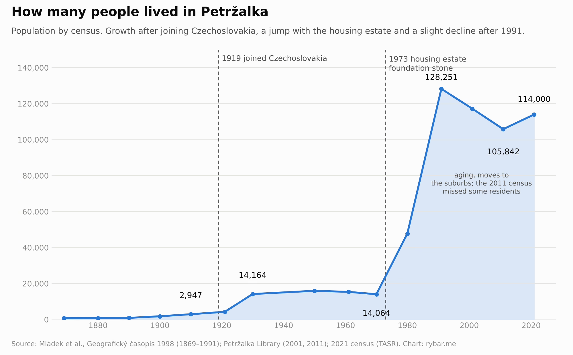
On the night of August 14, 1919, shortly after two in the morning, a group of barefoot men armed only with hand grenades crawled along the underside of Bratislava’s only bridge to the far bank of the Danube. They were hand-picked volunteers from Sokol, the gymnastics society that supplied much of the Czechoslovak Legions. The Hungarian garrison had mined the bridge, so the Sokol men first cut the fuses to the charges and then captured the guards. Behind them, battalions of the Guard of Freedom ran across the bridge barefoot so they would not be heard, and more soldiers crossed on pontoons. Almost without a fight they took a village its residents called Engerau and the Hungarian authorities Pozsonyligetfalu. The peace treaties that confirmed the new border were signed only later. Czechoslovakia kept the village, and apart from the years 1938 to 1945 it has been part of Bratislava ever since. Today it is Petržalka, home to 114,000 people, and it marks August 14 as the day it joined Czechoslovakia.
Why did a new state need to seize a piece of land across the river just so its Slovak center could feel safe? Why is Vienna three times closer to Bratislava than Banská Bystrica is, and why are both Budapest and Prague closer than Košice? Why is Bratislava the only capital in the world that borders two countries? Why were Hungarian kings crowned here for 267 years? Why did only one in seven residents speak Slovak in 1910? Why is the capital of Slovakia not in Martin, Žilina or Banská Bystrica? Why was Central Europe’s largest housing estate built right next to the barbed wire? And why do thousands of Bratislava residents live in Austria and Hungary today?
Once again, the answer is on the map. You just have to look at it up close.
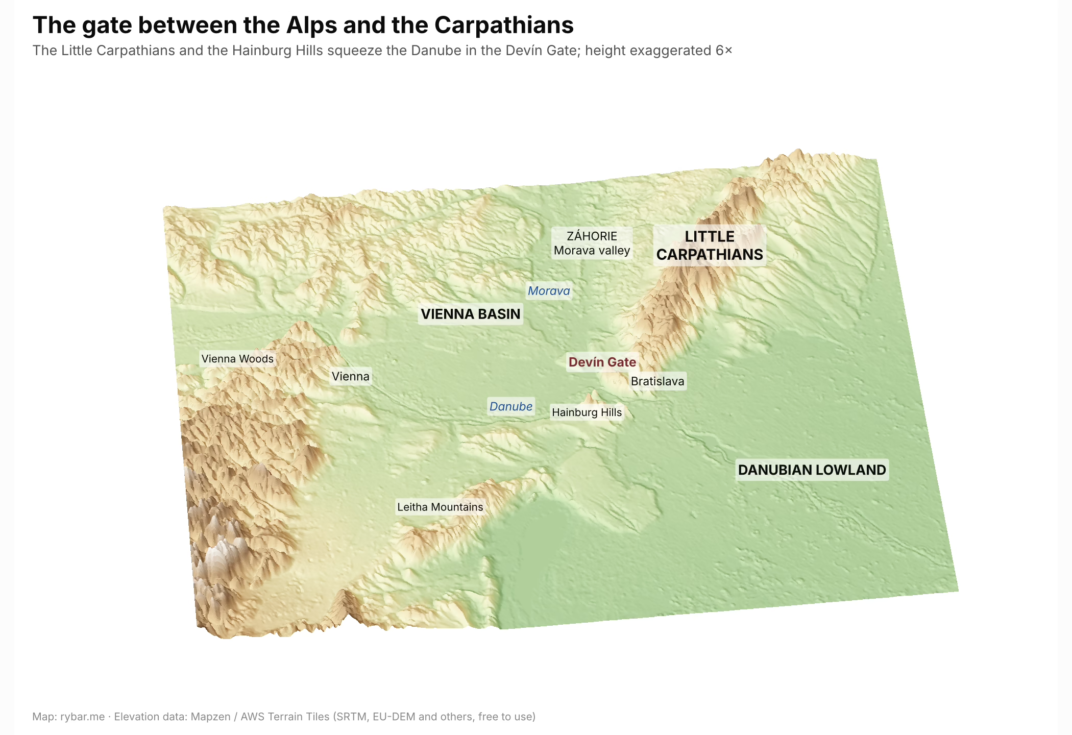
The gate
In the first part we saw that Slovakia is the northern rim of the Pannonian Basin, an arc of mountains and basins around a great plain. Bratislava lies where that arc begins. The Little Carpathians are the westernmost tip of the Carpathians, and they end right above the city, at Castle Hill and Devínska Kobyla. Across the Danube, the low Hainburg Hills continue, and behind them the Leitha Mountains, the last spurs toward the Alps. Between them the Danube squeezes through the narrow Devín Gate, which the Hungarians called Porta Hungarica, the Hungarian Gate.
In Central Europe the Danube has several such narrows where mountains close in on it. Together with Passau and the Iron Gates, the Devín Gate divides the Danube into its main sections. To the west lies the Vienna Basin, to the east the Pannonian Basin. Anyone who wanted to go from Vienna to Buda on the river or along it had to pass through here.
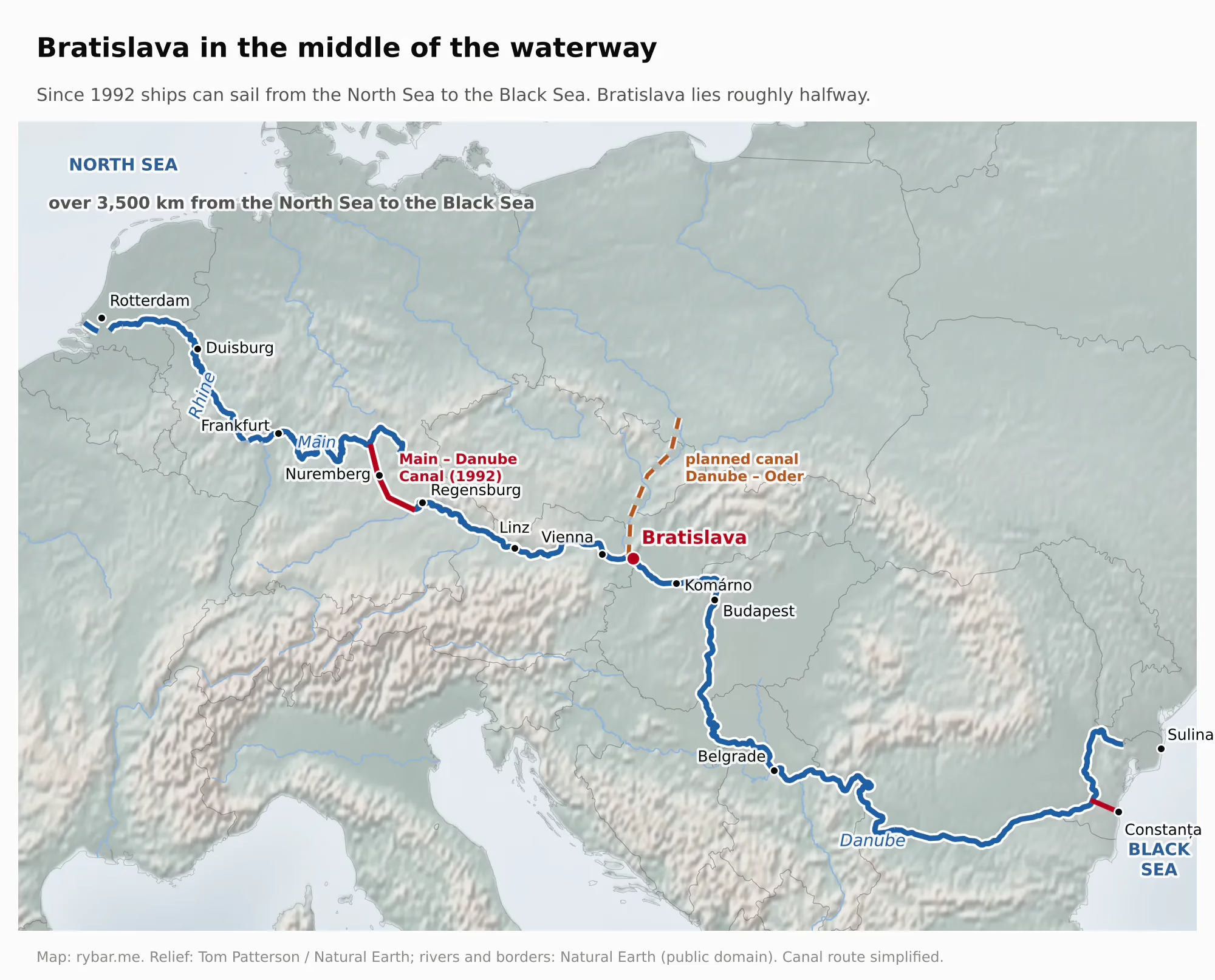
But Bratislava does not stand only on a river. At Devín the Morava flows into the Danube, and its valley carries the easiest route from Central Europe to the north, through the Moravian Gate to the Oder and the Baltic. In antiquity this was the Amber Road, along which amber traveled from the Baltic to the Mediterranean. So at Devín two of the continent’s main routes crossed: east–west along the Danube and north–south along the Morava. The idea of linking the two rivers with a canal all the way to the Oder has been around for centuries, and planners keep coming back to it.
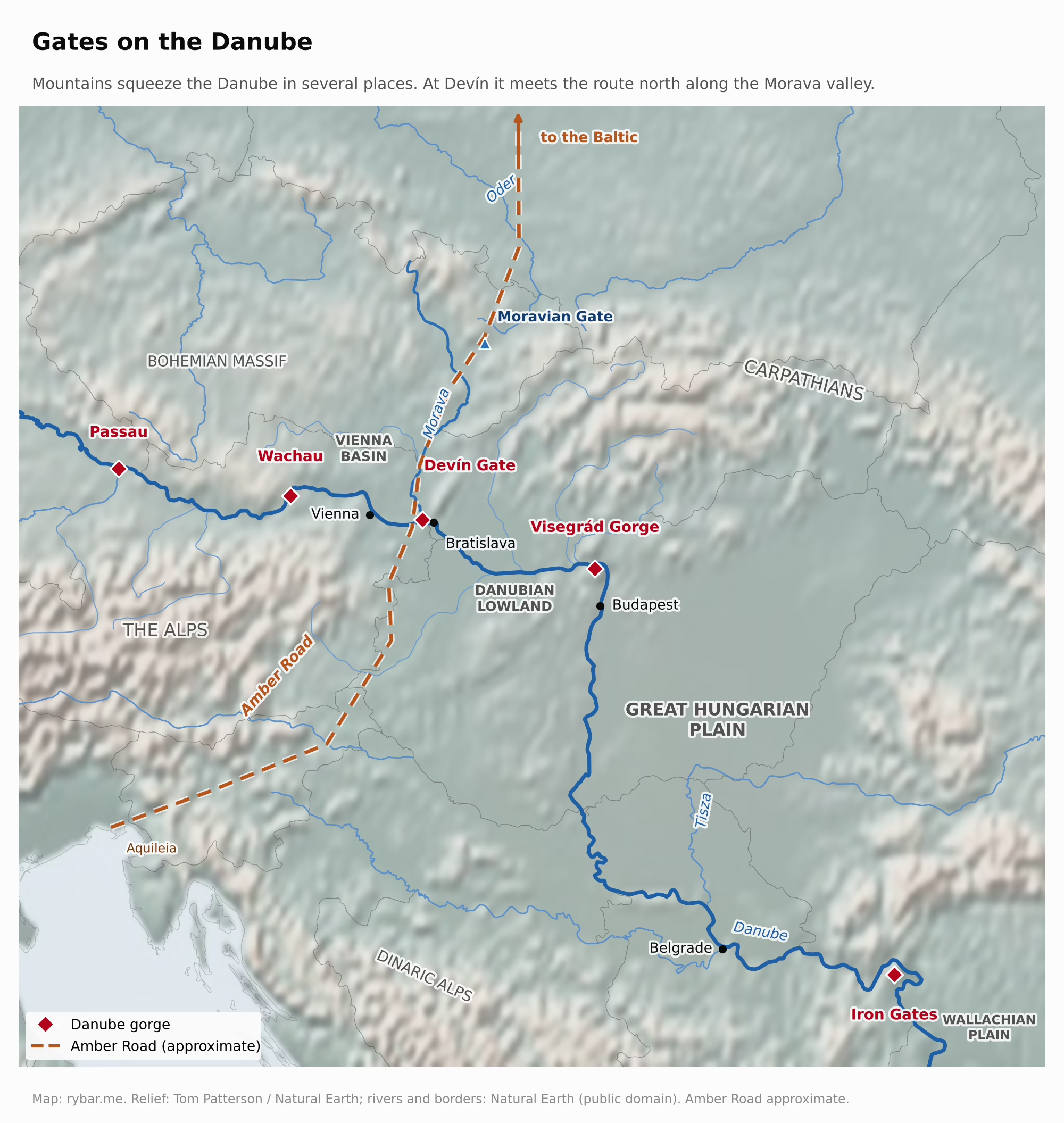
Below the gate the Danube slows down and spreads into a wide floodplain with arms and islands. The river could be forded here, and later bridged more easily, and above the ford stood a rocky crag on which a castle could be built. A gate, a ford and a rock: three reasons a city grew up here.
Tomas Pueyo summed it up in one sentence under a map in his article Why Is Hungary So Small?: Vienna and Bratislava guard the gates between the Pannonian Basin and the North European Plain. Both cities arose for the same reason and stand only 55 km apart, which by the commonly cited figure makes them the two closest capitals in Europe, if you leave out the Vatican and Rome.
The numbers show how close Bratislava is to its neighbors and how far from its own country. As the crow flies, it is 55 km from Bratislava to Vienna, 161 km to Budapest, 164 km to Banská Bystrica, 290 km to Prague and 313 km to Košice. Snina, at the eastern end of Slovakia, is 383 km away. Travel on the ground widens the gap further, because plains lead west and south, while going east means crossing mountains.

Everything else follows from this. This may be the most important sentence in the whole article: a city that arose as the guardian of a gate will never be in the middle of a country. It will always be where one country ends and another begins. The whole history of Bratislava is really a question of which side of the gate the border happens to be on.
The edge of Rome
This first became visible two thousand years ago. In the 1st century BC the Celtic Boii had a fortified town here, an oppidum, and minted their own coins inscribed BIATEC. Then came the Romans, and the Danube became the border of the empire. On the right bank stood a chain of forts, the so-called Danube Limes, and on the left bank began barbarian land, home to the Germanic Quadi and Marcomanni.
Almost all of today’s Slovakia lay outside the empire. There are two exceptions: the camp of Gerulata in Rusovce on the right bank, and the fort of Kelemantia in Iža near Komárno, a Roman bridgehead on the left bank. Since 2021 both have been UNESCO World Heritage Sites as part of the Danube Limes.
The center of the whole region lay 18 km from today’s Bratislava, at Carnuntum near present-day Petronell. From the year 106 it was the capital of the province of Upper Pannonia and the seat of a legion. From 172 to 175 it was the residence of Emperor Marcus Aurelius, who led the so-called Marcomannic Wars against the Marcomanni and the Quadi. In the camps by the Danube he wrote his Meditations. A note in the manuscript says he wrote the first book “among the Quadi on the Granua,” that is, by the Hron river in today’s Slovakia, and the second at Carnuntum.
Yet the Romans did venture farther across the Danube. The best-known trace is an inscription carved into the castle rock in Trenčín. It commemorates a victory of the emperors and 855 soldiers of the Second Auxiliary Legion who camped in the winter of 179/180 at a settlement called Laugaricio, about 120 km beyond the imperial border. The soldiers came from Aquincum, today’s Budapest, and advanced up the Váh valley. The inscription was commissioned by the legate Marcus Valerius Maximianus, and it is the most important Roman monument of its kind in Central Europe north of the Danube.
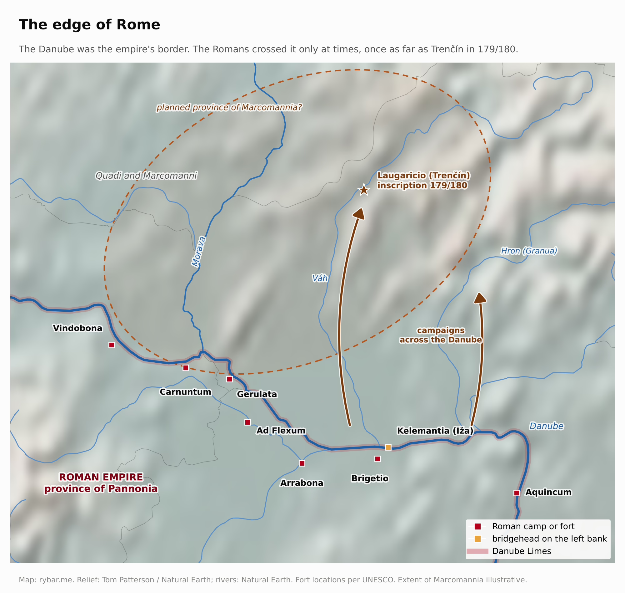
According to ancient authors, Marcus Aurelius wanted to set up two new provinces beyond the Danube, Marcomannia and Sarmatia. Some historians think he wanted to move the border from the river to the mountains, which are easier to defend. But he died in March 180, and his son Commodus made peace with the Germanic tribes and pulled the legions back to the Danube. The border stayed on the river for another two hundred years.
Why on the river? The broad Danube was a natural moat that could be seen from every watchtower, and at the same time a highway for moving soldiers, grain and building materials. On the far bank began forests, marshes and mountains without roads or towns, where an army would be hard to supply and the empire would gain little. So Rome stopped at the southern edge of a land that a thousand years later would become Slovak.
The territory of today’s Bratislava thus entered written history as a place on a border. Roman Gerulata even lies in one of the villages Slovakia gained only in 1947. We will come back to that.
A border that lasted a thousand years
After the Romans, Germanic tribes, Huns and Lombards passed through the gate, and in the 6th century the Slavs arrived. In 568 the nomadic Avars took over the basin, and the Slavs lived on its edge under their rule. In 623 they rebelled and chose a Frankish merchant named Samo as their leader. In 631 his tribal union defeated the army of the Frankish king Dagobert at a fortified site called Wogastisburg. Where Wogastisburg lay we do not know, and one hypothesis places it right by Bratislava.
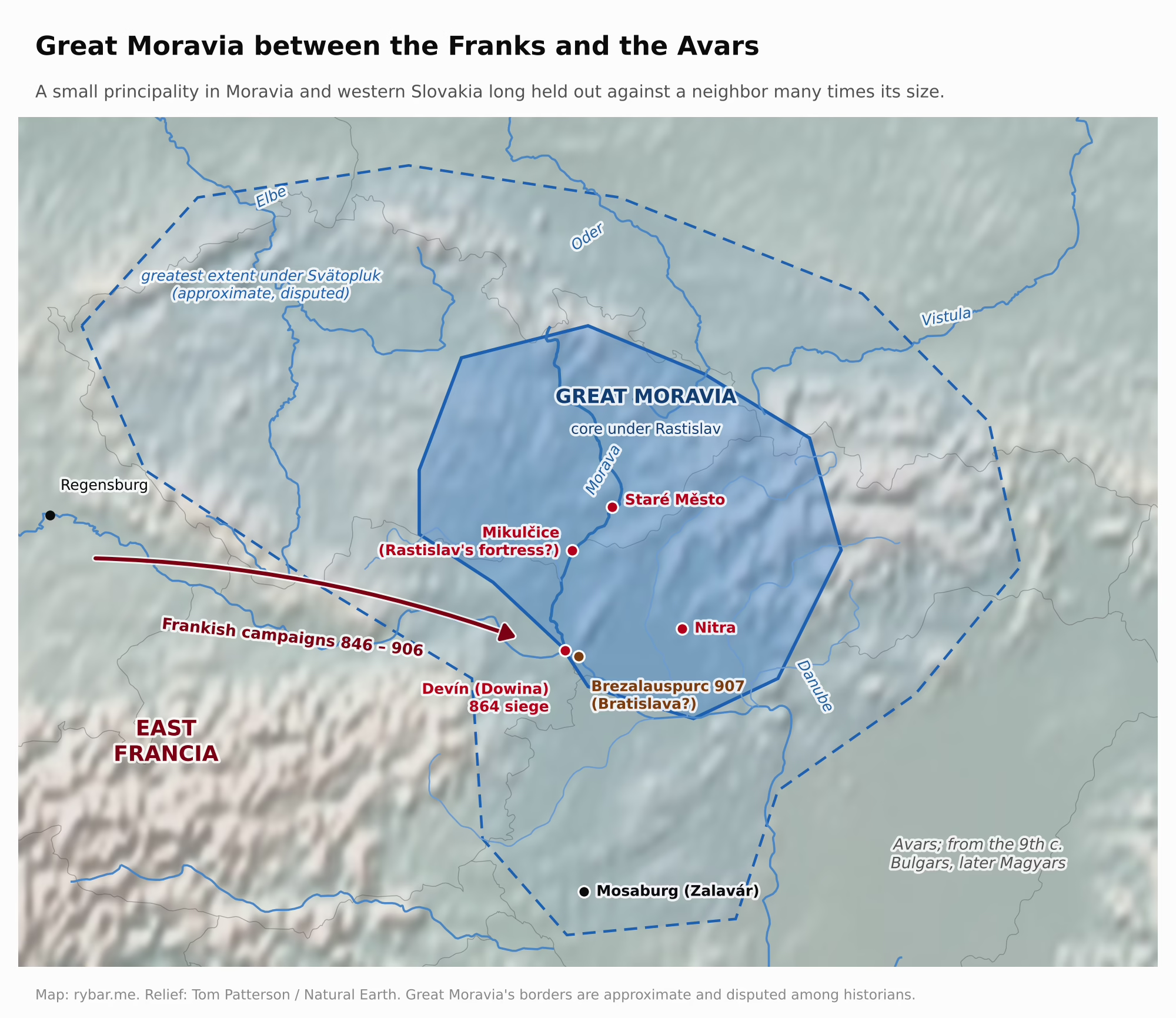
In the 9th century Great Moravia arose on the Morava river and in western Slovakia. Around 833 Prince Mojmír annexed the Nitra region, and his successor Rastislav tried to break free of Frankish rule. His neighbor was a giant. Around 814 the empire of Charlemagne covered roughly 1.1 to 1.2 million km², had 10 to 20 million people and stretched from the Atlantic to the Elbe. Even after the partition of 843, the East Frankish kingdom of Louis the German was many times larger than the Moravian core. Historical Moravia itself covers about 22,000 km².
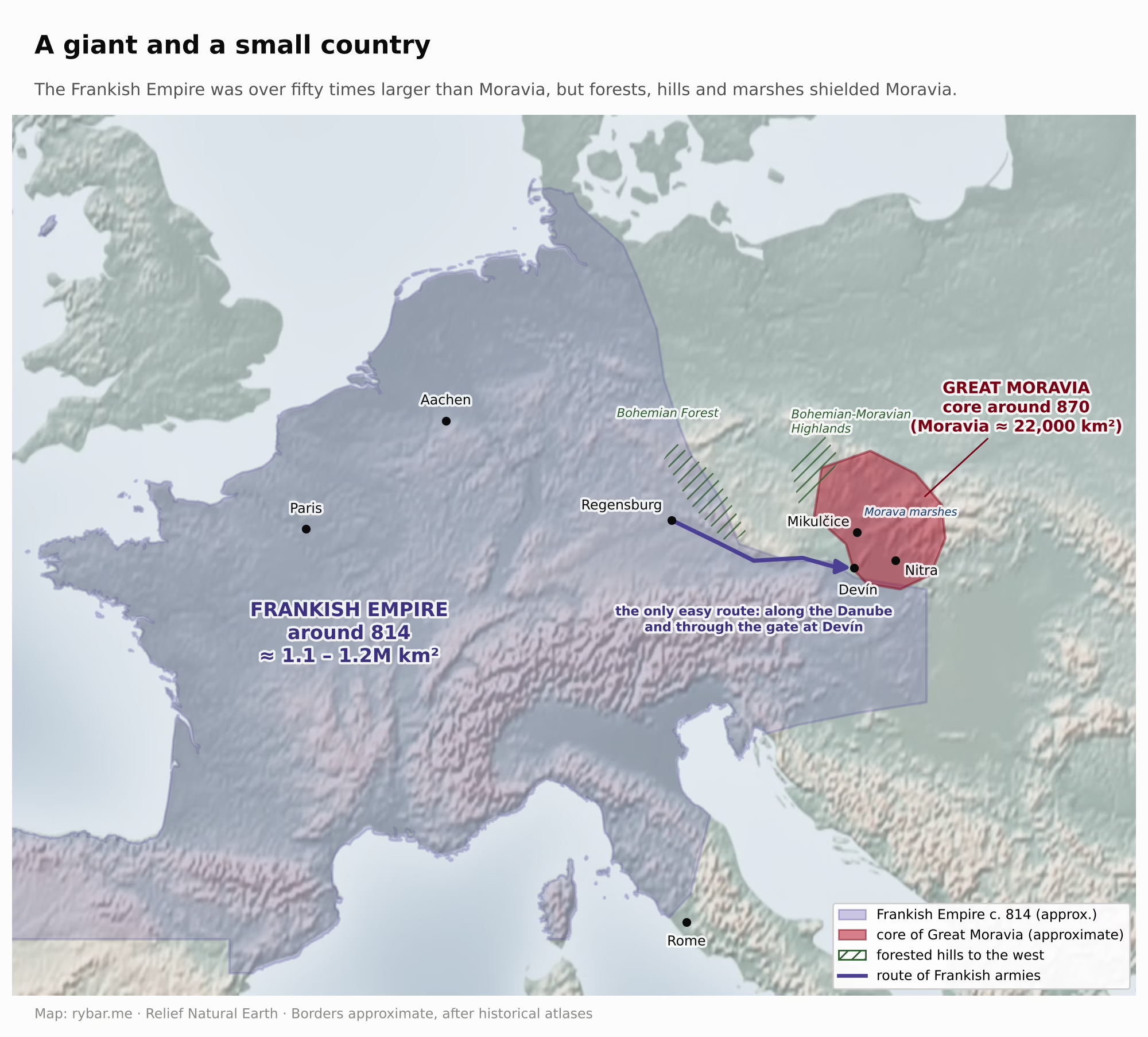
The Franks invaded Moravia again and again but never held it for good, and the terrain helped. Moravian centers sat on islands in the marshy floodplain of the Morava, like the fortified site at Mikulčice, or on rocks above rivers, like Devín and Nitra. To the west of them stretched forests and hills, and the only easy route from Bavaria ran along the Danube and through the gate at Devín. A Frankish army had to come from far away, carrying its supplies, and besiege water-ringed strongholds in unfamiliar terrain. Devín was Moravia’s western rampart. According to the Annals of Fulda, in 864 Louis the German himself besieged it, and Rastislav had to submit and hand over hostages. Soon, though, he broke free again. In 869 Louis’s youngest son Charles ravaged the country, but Rastislav held out in his fortress, which the annals describe as ineffable and unlike any ancient one, and which some historians identify with Mikulčice. What broke him was betrayal: in 870 his own nephew Svätopluk captured him and handed him over to the Franks. And in 871 Svätopluk defeated the Frankish army at “the old city of Rastislav” and freed Moravia. Under his rule the realm reached its greatest extent. Even then, the gate above the confluence of the Morava and the Danube was where powers met, and a small country managed to hold it precisely because it stood on the right side of it.
A few decades later the Magyars entered the basin. They were nomads from the Black Sea steppe, from a land they called Etelköz. In 895 and 896 they crossed the Carpathians, mainly through the Verecke Pass, and settled on the plains of the basin, which for riders with herds resembled the steppe. Around 900 they also took Pannonia west of the Danube and destroyed Great Moravia, weakened by a feud between Svätopluk’s sons. The first written mention of Bratislava dates from 907, and it concerns a battle. At a place the Salzburg Annals call Brezalauspurc, the Hungarian army destroyed a Bavarian army on July 4, 907. Historians still disagree on whether Brezalauspurc really stood on the site of Bratislava or near Lake Balaton. The battle’s outcome, however, is beyond dispute: the Bavarians gave up trying to win back Pannonia, and the Magyars stayed in the basin for good. Their raids into Western Europe ended only with their defeat on the Lech river near Augsburg in 955.
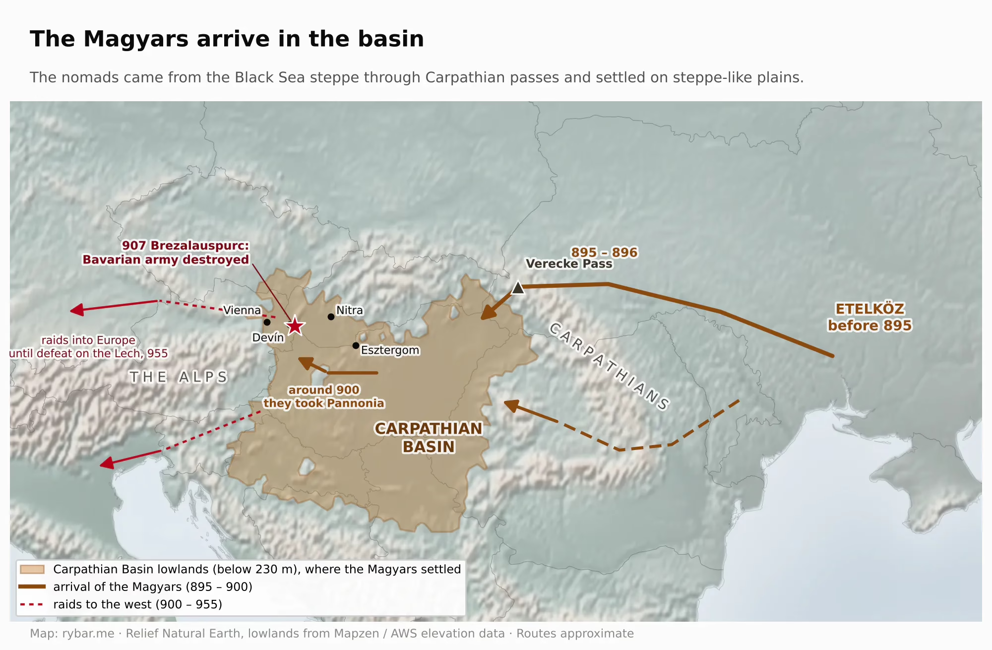
The new border settled where the terrain had set it. In the west, Hungary ended on the Morava and on the Leitha river beyond Hainburg, in other words right at the gate. With small changes it held there until 1921. Pressburg became a border fortress and the seat of one of the first Hungarian counties. In 1291 King Andrew III granted it town privileges, and it was settled mainly by German burghers. It was a Hungarian town that spoke German and looked toward Vienna.
The castle and the town
Castle Hill is the oldest address in the city. People settled on the raised crag above the ford as early as the Late Stone Age, the Eneolithic, and another settlement stood here in the Early Iron Age. In the 1st century BC the hill was the acropolis of a Celtic oppidum that spread over the castle grounds and today’s Old Town. Between 2008 and 2014, archaeologists uncovered stone buildings put up by Roman craftsmen and a store of Roman amphorae. So the Celtic elite here lived Roman-style even before the Romans reached the Danube.
What drew people here was the location. The hill is the last spur of the Little Carpathians, and its rocky crag rises about 70 meters above the Danube. Below it was a ford, where the road along the Danube crossed the road from south to north, and from the top you could see far across the plains on both banks. Whoever sat up there controlled the river crossing. On the hill you were also safe from the water. The flat land below belonged to the river, which spread into arms and, in high water, flooded everything up to the foot of the hill. The town grew up only later, on a gravel terrace between the hill and the river. It was high enough to stay dry in ordinary floods and close enough to the ford and the landing. Even so, in the biggest floods the water reached the town gates.
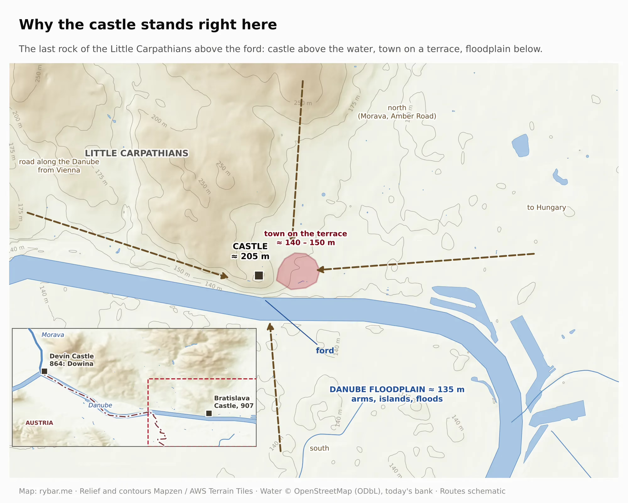
In the 9th century a Great Moravian stronghold stood on the hill with a stone church, a three-aisled basilica, surrounded by a large cemetery. Its foundations were partly damaged by Soviet troops, who moved into the castle in 1968. Many historians also place Brezalauspurc from the battle of 907, meaning Braslav’s castle, right here. In the 10th and 11th centuries a Hungarian border castle arose here, which the German chronicler Herman described in 1042 together with a densely built settlement below it. German King Henry III besieged it in vain for two months in 1052, and in 1108 Henry V tried and failed to take it together with the Czech prince Svätopluk. The foundations of today’s four-winged palace were laid by Sigismund of Luxembourg in the 1430s, when he wanted to turn it into a royal residence.
Bratislava Castle was not alone at the gate, nor was it the first in the sources. About ten kilometers upstream, on a crag above the confluence of the Danube and the Morava, at 212 meters, stands Devín Castle. While Bratislava Castle guarded the ford, Devín guarded the gate itself, the spot where the route along the Danube met the route north along the Morava. The rock has been settled almost continuously since the New Stone Age. Most historians identify Dowina in the Annals of Fulda, where Louis the German besieged Rastislav in 864, as we saw with Great Moravia, with Devín. So Devín appeared in written sources 43 years before Brezalauspurc. In the Kingdom of Hungary it was a border guard castle and the center of an estate that included Devín, Karlova Ves, Devínska Nová Ves and Dúbravka. In 1809 Napoleon’s troops mined it and blew it up. The ruin then became a national symbol, as we will see with the Štúr generation. In 1932 the Pálffy family sold it to Czechoslovakia for a symbolic 1,000 crowns, and six years later Germany occupied it.
Anyone who looks at Bratislava today sees the castle and the town below it as one whole. For centuries, though, they were two different worlds with different masters.
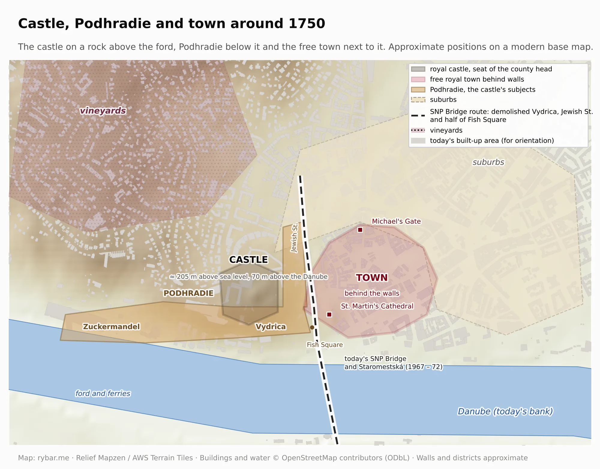
The castle on the crag above the Danube belonged to the king. It was the seat of the Pozsony county head and of the whole county, which governed the surrounding villages and nobility. The town below had royal privileges from 1291 and from 1405 was a free royal town with its own council, court and walls, and its burghers answered directly to the king, not to the county head. Between the castle and the town lay Podhradie, with the settlements of Zuckermandel and Vydrica. It belonged to the castle, not to the town: its subjects paid taxes to the castle and owed it labor, from mowing hay to the grape harvest. The town and the castle quarreled over land, over the right to sell wine and over who could do what to whom. Sometimes they quarreled with cannon. After the death of King Albert in 1439, a civil war over the throne broke out in Hungary. The town sided with Queen Elizabeth and her infant son Ladislaus the Posthumous, but the castle was held by their opponents, who shelled the town below. Cannonballs damaged, among other things, the Franciscan monastery and the town hall. A hundred and eighty years later the roles were reversed: in 1621 the imperial army of General Buquoy pounded the castle, held by Bethlen’s garrison, with heavy guns until a white flag went up on May 7. Podhradie became legally part of the town only in 1848 and in practice in 1851, when Bratislava bought it from the Pálffys, the hereditary county heads of Pozsony and captains of the castle.
The history of the whole kingdom played out at the castle. From 1608 to 1784 the Hungarian Holy Crown of St. Stephen was kept in its tower under the watch of the crown guard. Between 1751 and 1768 Maria Theresa had the fortress rebuilt as a grand royal residence. After her death it housed a seminary and then barracks, and in 1811 it burned down. For nearly a hundred and fifty years it stood above the city as a ruin, and as late as the 20th century there was serious talk of tearing it down. It was restored only in the 1950s and 1960s. Meanwhile, from the 1950s to the 1970s, Podhradie was almost entirely demolished. Zuckermandel gave way to the riverside road, and the SNP Bridge and its approach took Vydrica, Jewish Street and half of Fish Square with its Neolog synagogue, right next to St. Martin’s Cathedral.
Wine below the Carpathians
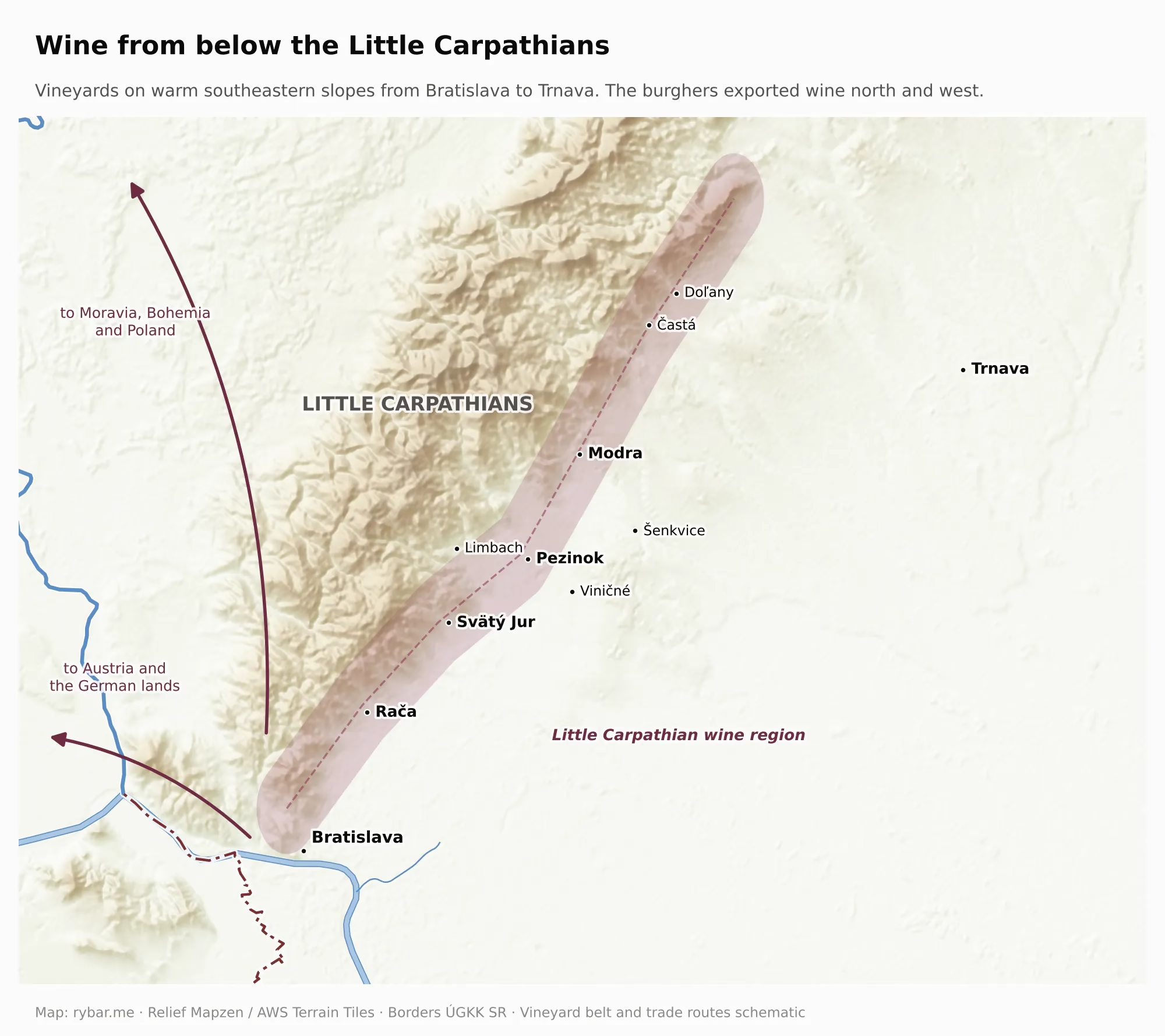
The town below the castle lived off what its location gave it: the vineyards on the slopes and the river below them. We will come back to the river; wine first. The southern slopes of the Little Carpathians are warm and sheltered from the north wind, and according to archaeologists vines were grown here as early as the 3rd century. The 1291 privilege of Andrew III mentioned above freed the burghers from the royal tax on vineyards, both existing and future. German colonists, who came in the 13th and 14th centuries mainly from the Rhineland, brought winegrowing know-how with them. Burghers of Bratislava and Trnava owned vineyards across the whole Little Carpathian region, in Modra, Pezinok and Svätý Jur, and exported wine to Moravia, Bohemia, Poland, Austria and the German lands. For centuries Bratislava was surrounded by vineyards. In the 19th century wine grew into an industry. In 1825 two Pressburg burghers, Johann Fischer and Michael Schönbauer, founded a sparkling wine factory using the traditional method of fermentation in the bottle, much as in Champagne. According to the company and to the German and Hungarian trade press, it was the first “champagne factory” outside France. Kessler in Esslingen, the oldest German sparkling wine house, was founded a year later, in 1826. Johann Evangelist Hubert joined the firm later, and after him it was run by his wife Paulína, even at the time when phylloxera destroyed vineyards across Europe. Pressburg sekt became a purveyor to the court of Franz Joseph I and was exported to America, Russia, Britain, Italy, Australia and India. That is how the vineyards below the Little Carpathians gave rise to the Hubert brand, which is made today in Sereď.
A capital in exile
Paradoxically, the city’s most glorious era came with a catastrophe for the whole country. In 1526 the Turks defeated the Hungarian army at Mohács, and in 1541 they took Buda. Hungary fell apart into three pieces. The Turks took the middle of the basin with Buda, the Principality of Transylvania arose in the east, and the Habsburg kings of Hungary were left with only a narrow strip in the north and west, the so-called Royal Hungary.

Look at the shape of that strip. Royal Hungary is almost exactly the rim of the basin we wrote about in the first part: today’s Slovakia, the western edge of Hungary and Croatia. The Turks took the plain; the Habsburgs held on to the mountains around it. And the capital of such a country had an obvious location: in the corner farthest from the Turkish front and closest to Vienna, where the king lived.
The third piece is just as instructive. Transylvania is an upland ringed by the arc of the Carpathians to the east and south and by the Apuseni Mountains to the west, and from the plain it could be reached only through a few passes and valleys. When the Ottomans took Buda in 1541, they did not occupy Transylvania but made it a vassal state. Formally they left it to the infant son of King John Zápolya; later the local nobility elected its princes and the sultan merely confirmed them. The princes paid him an annual tribute but ruled on their own. Politics played its part, but so did the mountains: conquering and holding an upland behind passes would have cost more than it would yield. The Ottomans ruled the plain directly and left the mountains around it to others: the Habsburgs in the north and west, the Transylvanian princes in the east. Just as the mountains protected Upper Hungary, they protected Transylvania. And it was from there that Gabriel Bethlen came when he took Pressburg in 1619.
Why Pressburg? The Hungarian nobility and the king needed a seat that would be both as far from the Turks and as close to Vienna as possible. Buda fell in 1541, and two years later so did Esztergom, the archbishop’s seat, and Székesfehérvár, where kings were crowned. Of the large towns the Habsburgs still held, Pressburg lay farthest from the front. Between it and the Turks stood a belt of fortresses: Komárno, Győr (Raab) and, from the end of the 16th century, Nové Zámky. They covered the route along the Danube to Vienna, the king’s seat. So Pressburg was protected by the same river that had once been Rome’s border: the fortresses stood on the Danube in front of it, and the Turkish army never took the city. From Pressburg it was only a day’s journey to Vienna by river or by the road along it, so the king had the diet and the government offices within reach. The Hungarian Chamber, the country’s highest financial office, had been based here since 1531.
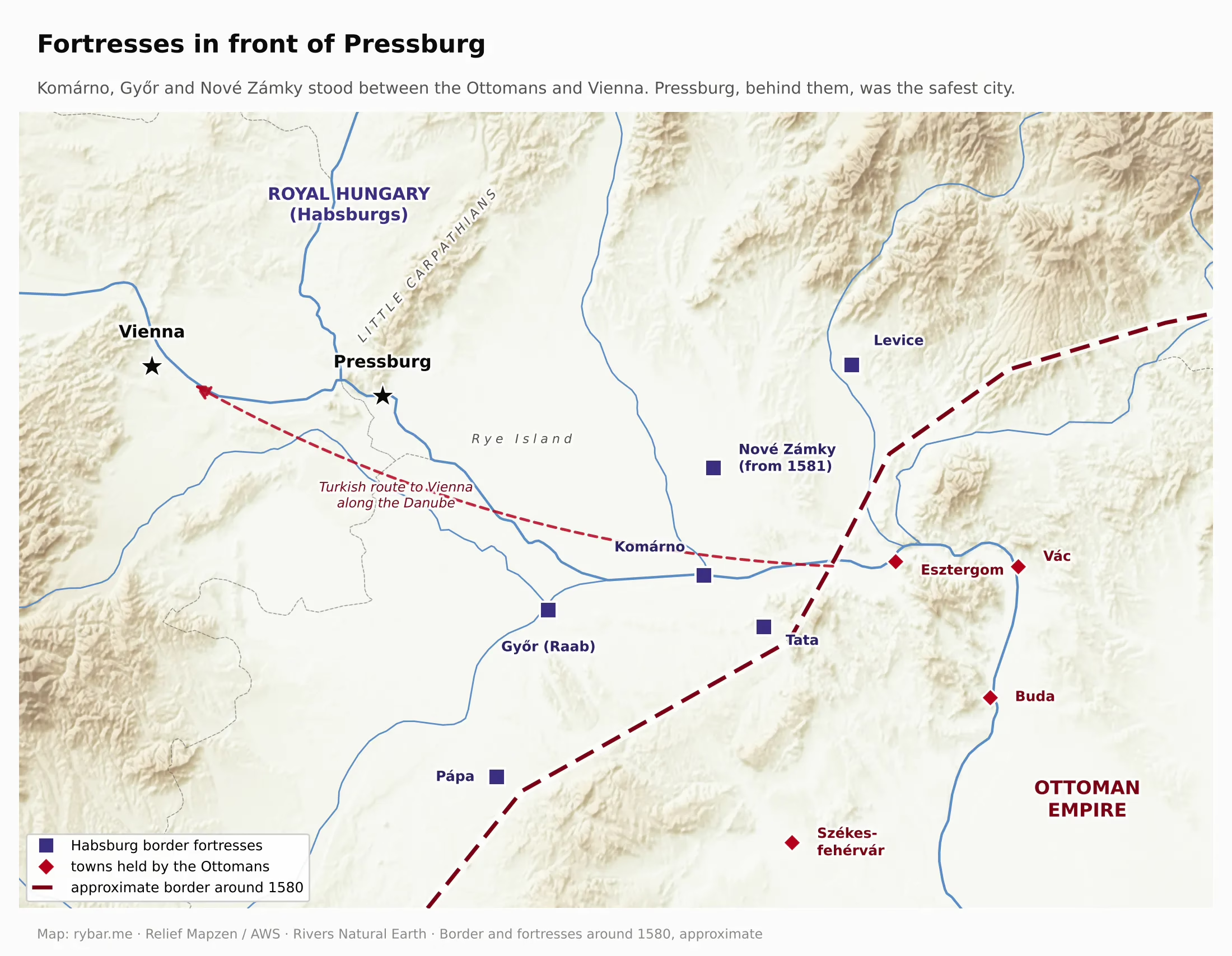
Pressburg became the capital of Hungary in 1536. From 1542 the Hungarian Diet met here, the Archbishop of Esztergom resided here, and between 1563 and 1830 ten kings, one reigning queen and seven royal consorts were crowned in St. Martin’s Cathedral. That queen was Maria Theresa, crowned on June 25, 1741. In September of that year, during the war with Prussia, the Hungarian nobles at the diet in Pressburg pledged her their “life and blood.”
But a capital near the border was vulnerable from within, too. The Hungarian nobility rebelled against the Habsburgs several times, mostly over religion and the privileges of the estates, and the city with the crown was the rebels’ greatest prize. In October 1619 the Transylvanian prince Gabriel Bethlen, mentioned above, took Pressburg and its castle, and the Palatine of Hungary handed him the Holy Crown. Bethlen summoned a diet here, and in August 1620 a diet in Banská Bystrica elected him King of Hungary, though he never had himself crowned. The imperial army retook Pressburg only in May 1621, as we saw with the castle. Peace between Bethlen and the emperor was signed in 1626, again in Pressburg. In July 1683, as the Turks marched on Vienna, the city opened its gates to the rebel leader Imre Thököly, an ally of the sultan. The rebels seized the city for the same reason it was the capital. Whoever held Pressburg held the crown, the diet and the route along the Danube to Vienna: the gateway to the whole kingdom.
The turning point came only with the Turkish defeat at Vienna in 1683. Imperial armies then gradually pushed the Turks out of the basin, and in 1686, after a long siege, they took Buda. With the Peace of Karlowitz in 1699, almost all of Hungary returned to Habsburg rule. Yet the capital did not move back to Buda for almost another hundred years. Buda had been ruined and emptied by the siege, the Turkish border was still close, and from 1703 to 1711 the country was torn by the uprising of Francis II Rákóczi. In 1704 his kuruc rebels ravaged the area around Pressburg and reached the outskirts of Vienna. Pressburg had the government offices, the nobility’s palaces, the crown in the castle and, above all, it was close to Vienna, where the king lived. For the Habsburgs it was also convenient to have the Hungarian Diet within reach.
That changed only under Joseph II, who wanted to run the monarchy uniformly from the center. In 1783 and 1784 he moved the most important offices, the Lieutenancy Council and the Hungarian Chamber, to Buda and had the crown taken to Vienna. The diet, however, kept meeting in Pressburg until the revolution of 1848. At its last session it passed the so-called April Laws, which abolished serfdom, and King Ferdinand V signed them in the Primate’s Palace on April 11, 1848. Then the diet moved to Pest. More than three centuries of Pressburg as the seat of the Hungarian Diet ended on the day modern Hungary was born.
Napoleon and the first bridgehead
It was Napoleon who first showed why the right bank matters so much.
In December 1805, after Napoleon’s victory over the Austrians and Russians at Austerlitz, a peace that cost Austria a large part of its territory was signed in the Primate’s Palace in Pressburg. Four years later Napoleon came back, this time with an army. In 1809 he took Vienna, and his marshal Louis-Nicolas Davout was ordered to seize Pressburg. The Austrians defended the city from a fortified bridgehead on the right bank, where Janko Kráľ Park in Petržalka is today. From June 1 to July 11, 1809, the bridgehead was fought over, and the French shelled the city from the right bank. The bombardment of June 26 destroyed several neighborhoods, and a cannonball from those days is still walled into the tower of the Old Town Hall.
The French did not take the city by force. But after the armistice of Znojmo they occupied it on July 14, 1809, and stayed until November 19. Napoleon visited on August 31, and according to local tradition he spread out maps of the city under a tree in the Petržalka park.
The battle for Pressburg shows how technology changes geography. As long as wars were fought with swords, bows and siege engines, the city was protected by the river as a moat and by walls with a castle on a rock. Gunpowder and artillery turned that around. Napoleon’s guns could fire a kilometer or more, while the Danube at the city is only about 300 meters wide. The river stopped being a rampart and became a firing line: whoever stood on the far bank did not need to take the city; shelling it was enough. The walls lost their purpose, and between 1775 and 1778, by decision of Maria Theresa, Pressburg tore them down, filled in the moats and merged with its suburbs. Defense moved out in front of the city, to a bridgehead on the far bank. With every gain in range, the need for depth grew too. In the 20th century guns fired tens of kilometers, and a bridgehead that was enough in 1809 was no longer enough.
The lesson of 1809 was clear. Whoever controls the right bank can shell the city even without taking it. A hundred and ten years later, Czechoslovak soldiers and diplomats would remember that lesson.

Railroads and a tram to Vienna
Without the diet and the coronations, in the second half of the 19th century Pressburg became a provincial town in the shadow of fast-growing Budapest. But the gate kept working, and new technologies only strengthened it.
In 1840 a horse-drawn railroad opened from Pressburg to Svätý Jur, the oldest in what is now Slovakia, and it was later extended to Trnava. In 1848 a steam railroad reached the city from Vienna and soon continued along the Danube to Pest. Pressburg thus found itself on the main line between the monarchy’s two capitals. As we saw in the first part, Hungarian rail lines formed a star around Budapest. Pressburg lay on its western edge, and from there the only way to northern Slovakia was up the Váh valley. In 1891 the first permanent bridge across the Danube was added, carrying trains as well, and we will come back to it.
In 1914 the Pressburger Bahn started running, popularly called the Vienna tram. It was an electric line almost 70 km long that took you from the streets of Pressburg across the bridge and through Petržalka all the way to downtown Vienna. Until October 1918 it crossed the border between the Austrian and Hungarian halves of the monarchy without any checks. Vienna and Pressburg were becoming a single metropolitan area. Four years later, World War I and the breakup of the monarchy cut that short.

The wild Danube: river arms, fish and taming the river
Today the Danube in Bratislava is a single wide channel between stone embankments. A hundred and fifty years ago it was not. Below the Devín Gate the river spread into dozens of arms with gravel islands, floodplains and riverside forests between them, and every big flood redrew them. Petržalka was not a plain across the river but an archipelago. Andrej Erik Fritsch’s map of 1753 shows a whole string of named islands on its territory, and the geographer Peter Pišút found that in the second half of the 18th century the Danube’s side erosion carried away about a third of the village, houses and gardens included. In the 17th and 18th centuries the largest arm in Petržalka was the Croatian arm, which today survives only as a narrow canal between housing blocks. The big island of Pečňa left behind the Pečňa forest. The First Military Survey of 1782 to 1785 shows the river splitting into several arms below the city and breaking up into a system of islands below Rusovce and Čunovo, the so-called inland delta.
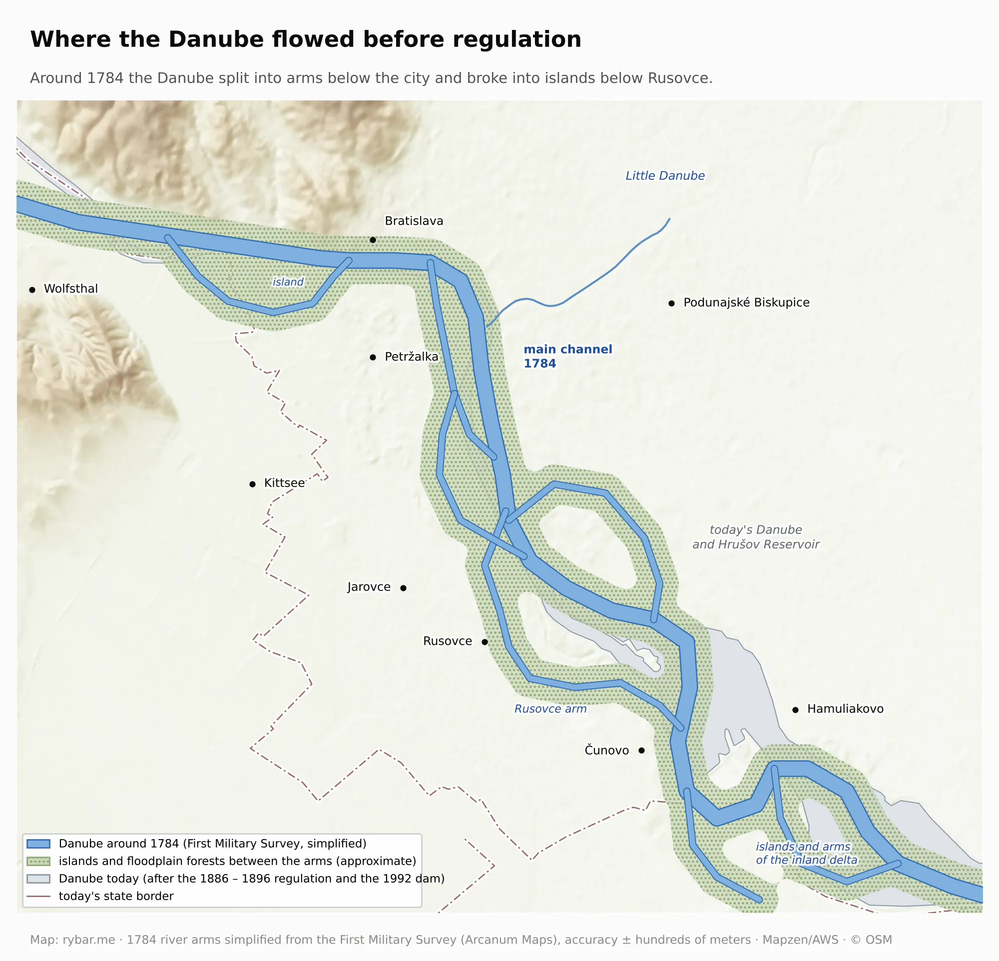
On the left bank it was similar. East of the city flowed the Čalovo arm, also called the Nové Zámky arm, and between it and the main stream lay islands where Mlynské nivy, the Winter Harbor and shopping malls stand today. The river was also dangerous. In the flood at the turn of October and November 1787, the water reached the Fishermen’s Gate and broke the dike at Kopčany. The biggest known flood came in early 1850, when water inundated part of the historic center.
The wild river was also rich. The calm arms were full of fish, as names in the city still recall: the Fishermen’s Gate and Fish Square. The most prized fish was the beluga, a sturgeon that every year swam upstream from the Black Sea and could grow up to seven meters long. It was caught for its meat and for caviar. Overfishing, river regulation and finally dams drove the beluga out of our part of the Danube. The last beluga on the upper Slovak–Hungarian stretch was recorded in 1958 in Hungary’s Szigetköz. Since 1972 the Iron Gates dam has blocked its way from the sea for good, and today Gabčíkovo would stop it too. Of the native sturgeons, only the sterlet survives here, and conservationists are releasing it into the river again.
A river like that was hard to bridge, which is why a permanent bridge across the Danube in Bratislava is a fairly recent thing. For centuries people crossed by the ford below the castle and by ferries. Sigismund of Luxembourg had the first wooden bridges built around 1430 by the Water Tower, and Matthias Corvinus built more in the 1470s and 1480s, but every few years the river took them away with floods or ice. For coronations and diets, temporary bridges of boats were built and then taken apart. From 1676 to 1825 a flying ferry operated: a large ferry on a cable anchored in the middle of the river, carried from bank to bank by the current itself. It was replaced by the Caroline Augusta bridge, made of boats laid side by side, whose middle section opened to let large ships through. Pressburg got its first permanent bridge, the Franz Joseph Bridge, today’s Old Bridge, only in 1891, and it was the only one until 1972. Budapest was not much earlier: its first permanent bridge across the Danube, the Chain Bridge, opened in 1849.
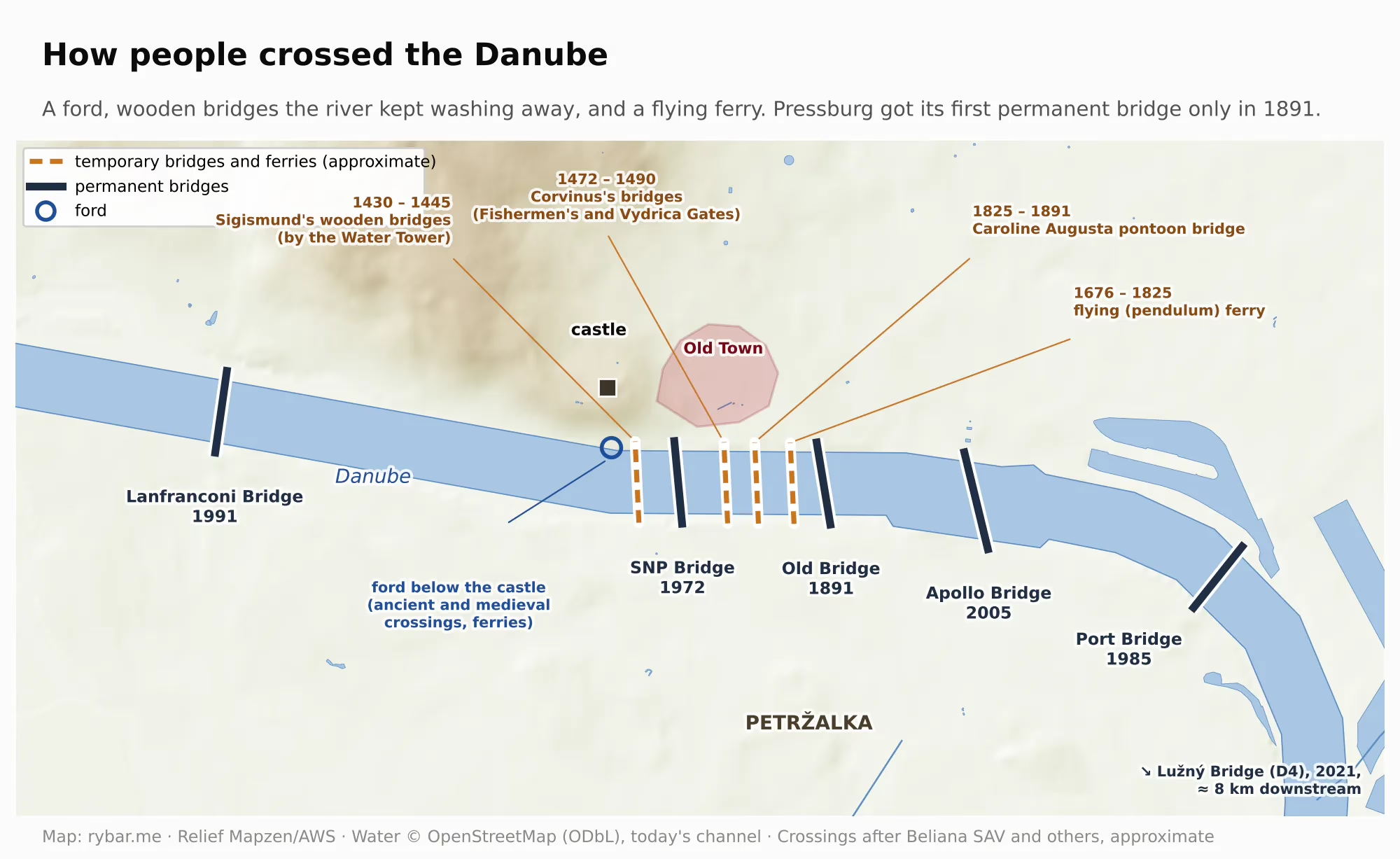
When the bridge opened in 1891 and the old pontoon bridge was removed, the entrepreneur Heinrich Hörnes got a license to run steam ferries across the Danube. His boats were driven by a screw propeller, Propeller in German, and the whole line was named after it. The Propeler carried people from the Old Town to the Petržalka parks, swimming pools and amusement park until 2003. Its functionalist station by Emil Belluš from 1930 still stands on the embankment.
In the end, engineers tamed the river. The first works on the Bratislava stretch began as early as the 1770s, sped up after the flood of 1787 and continued through the 19th century. The decisive regulation of 1886 to 1896, however, was designed by the Italian engineer and businessman Enea Grazioso Lanfranconi. Born in 1850 in Lombardy, he followed his parents to Pressburg after studying in Milan and drew up a hydrological map of the Danube from Bratislava all the way to Romania. To him the river was above all a transport route: cheap water transport was to feed the industry and trade of a country rich in raw materials. He proposed reinforcing the banks with stone dikes, closing off the side arms and digging several artificial channels so that the river would scour a single deep bed by itself. The works covered about 80 km of river and used more than 3.5 million m³ of stone, much of it from his own quarries near Devín. Lanfranconi died at 44, before the regulation was finished. He is remembered by a bridge from 1991, whose name was misspelled for years as Lafranconi.
We still see the result today. The Čalovo arm was filled in, and on the new flat land an industrial district grew up with a railroad, and from 1897 to 1907 the Winter Harbor too. The Petržalka arms were cut off from the main stream and gradually silted up, so the archipelago became a continuous plain that could be built on: first parks and swimming pools, later Central Europe’s largest housing estate. Even so, the arms did not disappear completely. When the SNP Bridge was being planned in the 1960s, building it near today’s Riverpark was considered, but on the Petržalka side the large Pečňa arm was still in the way. Regulation was not only meant to protect the city from water. It was meant to make the Danube a better road.
The Danube: a road, a fleet and a port
The gate was above all a river route, and for centuries the river was the cheapest way to move heavy cargo. But for trade, the Danube flowed in the wrong direction. Going downstream was easy, often on boats that were broken up for timber after a single trip. Upstream they had to be hauled by horses along the bank, and the trip upstream from Vienna to Passau took 20 to 31 days. Shipping Hungarian grain up the river to Vienna was therefore expensive.
Why bother with the river at all? Because for centuries it has been the cheapest and most efficient way to move heavy cargo. British data, which historians have compiled for three centuries, show this best. Around 1700, moving a ton of goods one mile by wagon on the road cost about 1.2 shillings, and by navigable river about a tenth of that. The canals the British built in the 18th century brought the cost down by 1790 to about a quarter of a shilling, 80% less than a wagon. In 1865 the railroad carried a ton one mile for a tenth of a shilling in 1700 prices, twelve times cheaper than a wagon a century and a half earlier. In America, moving a ton one mile by wagon cost about 38 cents in 1784, and by rail in 1900 less than one cent. The railroad was thus the first way on land to compete with the river, and from the 19th century on it took away mainly fast and higher-value goods.
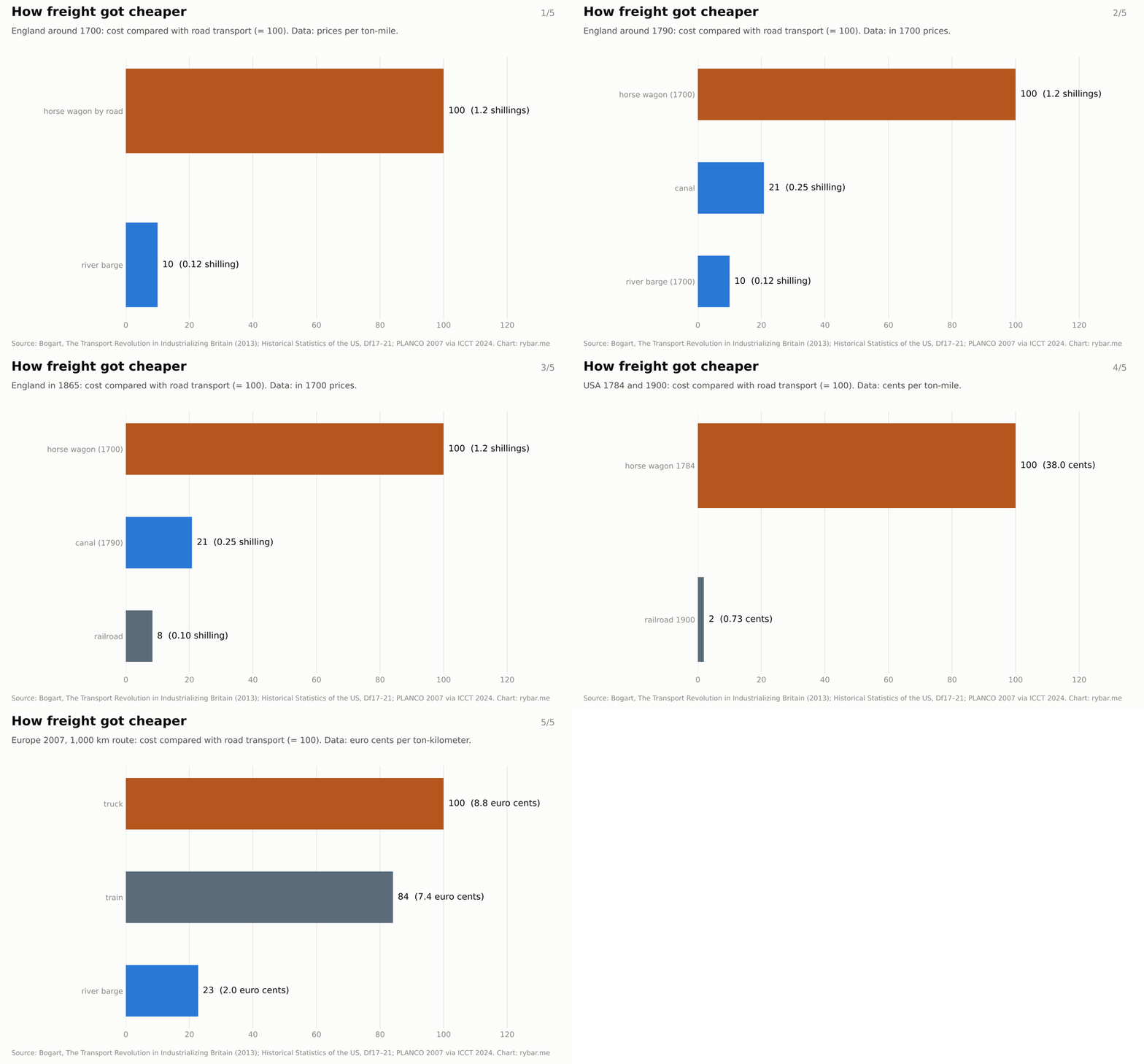
The ranking is still the same today. According to a 2007 German study by PLANCO, cited by the ICCT, moving a ton one kilometer over 200 km cost about 14 euro cents by truck, 16 by train and just under 3 by ship. Over 1,000 km it was 8.8 cents by truck, 7.4 cents by train and 2 cents by ship. According to the Polish ministry, the same energy moves one ton of cargo about 370 km by ship, about 300 km by train and only about 100 km by truck. According to US figures, a standard cargo barge carries as much as 70 trucks or 16 rail cars. But a ship is slow, depends on the water level, which drops in droughts, and goods have to be transferred at the port from trucks and trains and back. That is why the Danube carries mainly bulk and oversized cargo, such as raw materials, grain or heavy machinery. The river’s share of total transport is small. In the first quarter of 2024, trucks in Slovakia carried almost 34 million tons of goods, trains more than 10 million, and water, air and pipeline transport together about 6 million tons.
The river was also a military road. During the Turkish wars the Habsburgs had their own river troops on the Danube and a flotilla that anchored at Komárno, under the protection of a fortress the Turks never took. The river soldiers on fast boats called šajkas were known as šajkaši, and according to historians their corps had its headquarters in Komárno. After the revolution of 1848–1849 a new Danube flotilla was founded with its base in Pest, and from 1871 it included armored river monitors. In World War I they shelled Belgrade, and in 1918 they made it all the way to the mouth of the Danube.
Then came steam. The first steamer of the Austrian Danube Steamship Company, DDSG, the Franz I, sailed past Pressburg in September 1830 from Vienna to Pest in fourteen and a half hours. The return trip upstream took 48 hours. Ten years later you could take a steamer all the way to the Black Sea and on to Constantinople. But the railroad soon took passengers away from the river: in 1930 the train from Vienna to Budapest took just under five hours. For heavy goods the Danube remained the better deal, and in 1897 construction began in Pressburg on a winter harbor, the first large sheltered harbor on the Hungarian stretch of the Danube.
Cargo volumes back then were much smaller than you might expect. The French engineer Charles-Joseph Minard calculated that in the 1850s about 321,000 tons of goods a year moved on the stretch of the Danube between Vienna and Orșova, compared with 1.4 million tons on the Rhine and 1.8 million tons on the Elbe. The Danube was shallow, full of side arms and blocked by rocks at the Iron Gates. It grew only with steam and regulation: in 1880 the DDSG was the largest river shipping company in the world, with more than 200 steamers and about a thousand cargo barges, and after the Iron Gates were made navigable in 1898, the Danube became a true international corridor. In 1911 the ports of Vienna handled about 1.8 million tons of goods.
Pressburg was only a small stop on this route. Even at the end of the 19th century, goods here were still transferred by hand and with animals, and the DDSG built the first port crane only in 1916. In 1913 the port of Bratislava handled just 41,370 tons.
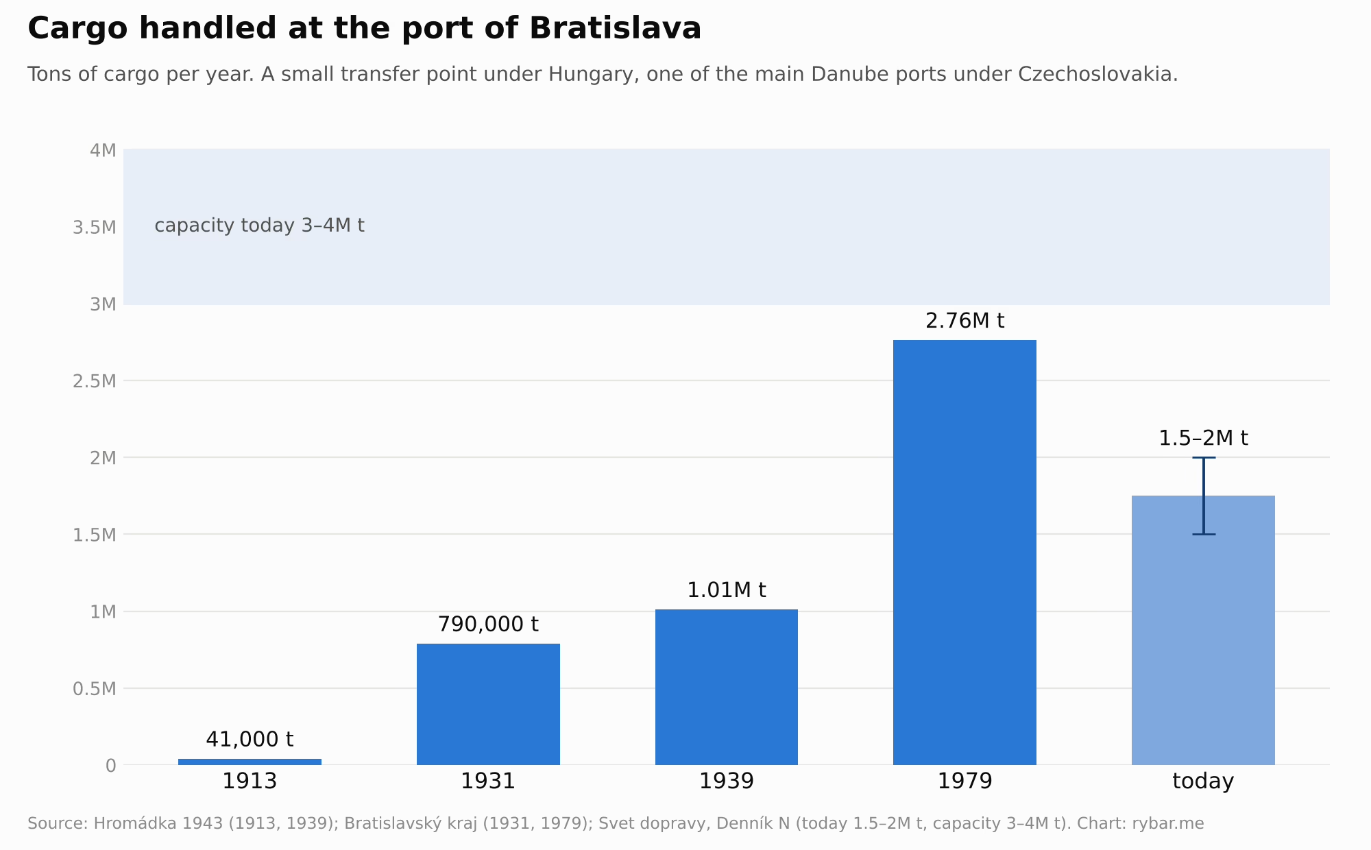
For Czechoslovakia, the port was one of the main reasons it wanted Bratislava. As early as March 1919 a Czechoslovak Danube Transport Office was set up in Bratislava. A 1921 government bill described the port of Bratislava as destined by nature to be a first-class river port with the most advantageous location on the entire course of the Danube. After the war the Danube became an international river under the supervision of an international commission, so a landlocked state gained its own route to the Black Sea. In 1922 parliament approved the founding of the Czechoslovak Danube Shipping Company, based in Bratislava, which went into full operation in 1924. It started with five steam tugs and 44 towed barges, and today we know it as Slovenská plavba a prístavy. Between 1920 and 1932 the state rebuilt the port, adding cranes, warehouses and a mineral oil terminal. Cargo handled rose to 790,000 tons in 1931 and in 1939 passed a million tons for the first time. Bratislava, an insignificant transfer point under Hungary, became one of the most important ports on the Danube within twenty years.
World War II cut this short. From 1944 Allied aircraft bombed the Danube ports and mined the river. After the war, Czechoslovak shipping carried only 6,000 tons in 1945, but by 1948 it was 347,000 tons, more than it had carried itself before the war. Under socialism the direction of trade turned east. Iron ore for the steelworks flowed up the Danube from the Soviet Union, and in the 1970s a new port basin, Pálenisko, was built for it. In 1979 the port of Bratislava handled 2.76 million tons.
Today Bratislava lies on the Rhine–Main–Danube waterway, which since the Main–Danube Canal opened in 1992 has linked the North Sea with the Black Sea over more than 3,500 km. The port of Bratislava has a capacity of 3 to 4 million tons of goods a year, but actually handles only 1.5 to 2 million tons, less than in 1979. In recent years iron ore, petroleum products and steel materials have dominated. But another 6 to 8 million tons of goods pass the city on the Danube every year without stopping. The port can handle loads weighing up to 560 tons, and container trains from China pass through it too. In 2024 the government designated the port’s modernization a strategic investment, with the goal of tripling the cargo it handles.
A city of three languages
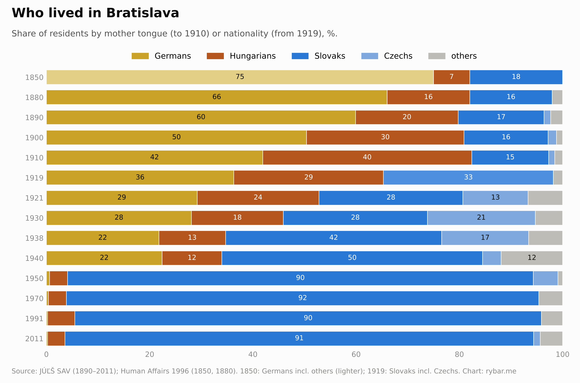
The city at the gate was multilingual from the start. It stood at a crossroads of trade routes and on the boundary between countries, and anyone going through the gate went through the city too. Merchants, soldiers, craftsmen and refugees mixed here for centuries. Slavs lived below the castle, east of the town stood the Hungarian settlement of Széplak even before 1291, and from the 13th century German colonists arrived and became the town’s elite. The town council and burghers spoke German, the Slovak residents were mostly craftsmen, vinedressers and the poor, and as the capital of Hungary, Pressburg attracted nobles from across the kingdom. After Mohács in 1526 the town expelled its Jews. From 1599, however, the Pálffys allowed them to settle below the castle, on the Schlossberg and in Zuckermandel, outside the town’s jurisdiction, and in 1707 they protected about 200 Jewish families there, many of them refugees from Vienna. In the 19th century the diet met here until 1848, speaking Latin and increasingly Hungarian, but on the street German remained. In the 1850 census Pressburg had about 42,000 residents; 18% counted as Slovaks and only 7% as Hungarians. In 1880 about two-thirds of the people spoke German.
In 1910 Pressburg had 78,223 residents and was the largest city in what is now Slovakia. Košice had 44,211. But it was not a Slovak city. 41.9% of residents gave German as their mother tongue, 40.5% Hungarian and only 14.9% Slovak. About a tenth of the population were Jews, who in the census mostly declared German or Hungarian. Yet as recently as 1890, almost 60% of people had spoken German and less than a fifth Hungarian. In twenty years the city was heavily Magyarized, not only through migration but also through pressure from the state and the authorities.
After 1918 the balance flipped just as quickly, this time in favor of Slovaks and Czechs. In the special census of 1919, 36% of residents declared German nationality, 29% Hungarian and 33% Czechoslovak. In 1930 Bratislava had 123,844 residents: 28% Germans, 18% Hungarians, 28% Slovaks and 21% Czechs. Officials, teachers, soldiers and workers moved into the city, while some Hungarians left for Hungary. World War II and the years after it changed the city completely. In 1939 Czechs had to leave the Slovak State, Bratislava’s Jews were deported to concentration camps in 1942 and 1944, Germans were evacuated at the end of the war and expelled after it, and some Hungarians left in the population exchange. In 1950, 90% of Bratislava residents declared themselves Slovak, and less than one percent were still German.
According to a well-known anecdote, when old Pressburgers were asked whether they were Hungarians or Germans, they would object: “Wir sind halt Pressburger.” We are Pressburgers. The city at the gate had its own identity that did not match any nation.
Paradoxically, this is where modern Slovak was born. Ľudovít Štúr taught at the Lutheran Lyceum in Pressburg, and around him grew up the generation that gave Slovaks their standard language. As early as the beginning of the 19th century, the lyceum’s Slovak students revived the old Slavic name of the city, Břetislava, from which Bratislava later came. Their symbol became Devín, which we mentioned with the castle. On Sunday, April 24, 1836, about sixteen lyceum students climbed its ruins with Štúr. Štúr gave a speech there about the Great Moravian past, and each of them added a Slavic name to his given name. Štúr chose Velislav, and that is why we know Jozef Miloslav Hurban and Michal Miloslav Hodža. In 1843 the Štúr circle agreed in Pressburg to base the standard language on the Central Slovak dialect. So the Slovak nation looked for its language in the mountains but learned it in a German-Hungarian city on the Danube.
1919: why Bratislava
When Czechoslovakia was founded in October 1918, it was far from clear that Pressburg would be part of it. Local Germans and Hungarians wanted to keep it in Hungary, some Germans considered joining Austria, and there was even an idea of a free city. Slovaks in America proposed calling it Wilson City, in honor of the US president. The Czechoslovak army entered the city on the night of January 1, 1919, and on February 4 the Ministry with Full Powers for the Administration of Slovakia, headed by Vavro Šrobár, moved there from Žilina.
Eight days later, on February 12, 1919, German and Hungarian associations called a general strike, and thousands of people gathered on what is now SNP Square to protest against the new authorities. Soldiers fired into the crowd. At least six people were killed, nine according to some sources, and dozens were wounded. The event is known as Bloody Wednesday, and for a long time Slovak history said little about it. In March 1919 the city officially got a new name: Bratislava.
Why did the new state try so hard to get a city where Slovaks were a minority? The reasons were practical, and almost all of them had to do with its position at the gate. Bratislava was by far the largest city in Slovakia. At the same time, it was small. In 1910 it had 78,000 residents, while Vienna had more than two million and Budapest 880,000, that is 26 and 11 times as many. Nor did it stand out next to Czech cities. Prague had 224,000 residents, and together with suburbs such as Vinohrady, Žižkov and Smíchov, which were merged into it in 1922, more than half a million. Brno had 126,000 and Plzeň 80,000, about the same as Bratislava. In Slovakia the new state did not get a metropolis but the largest town of a rural country. It lay on the Danube, an international river, so landlocked Czechoslovakia gained a port with a route to the Black Sea. It had railroads to both Vienna and Budapest, and it was close to Moravia, and so to Prague.
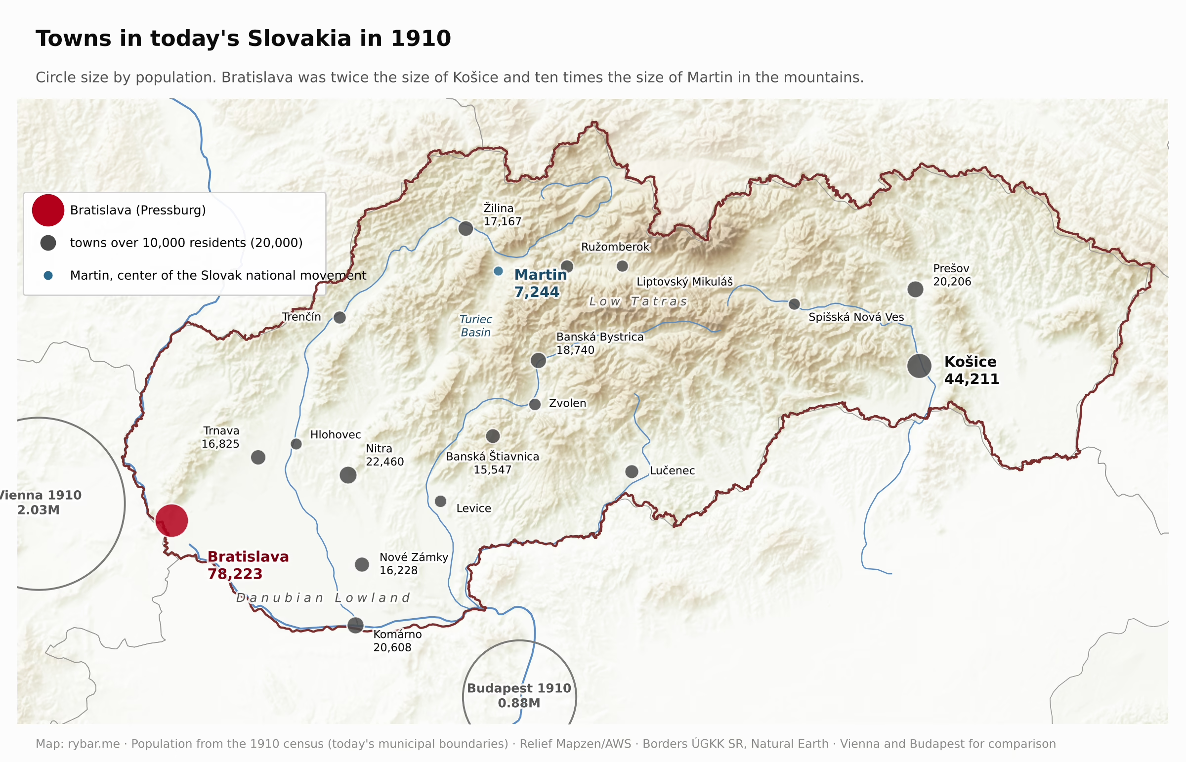
Slovak patriots, meanwhile, had their natural center elsewhere. From the 1860s it was Martin, where the Memorandum of the Slovak Nation was drawn up and Matica slovenská was founded. In Turiec, a basin in the middle of the mountains, Slovaks lived, while in Bratislava they did not. Critics later objected that the capital lay in a corner of the country. But the Danube, the railroads and the city’s strategic importance decided it. Samuel Zoch, the head of Bratislava county, was seen as especially successful; he argued that capital status would turn Bratislava into a Slovak center.
The argument over the capital went on afterward. In 1919, in a pamphlet titled The Capital of Slovakia, Fedor Ruppeldt argued that the center should be Martin, and later he called for moving the university there as well. Many countries have ultimately built brand-new capitals: Brazil built Brasília, Pakistan Islamabad, Nigeria Abuja, Kazakhstan Astana. Today Indonesia is building Nusantara and Egypt its New Administrative Capital. Such projects cost huge sums, take decades and often stall when their originator is replaced by someone else. Slovakia never had the reason or the money for anything like that. Nor would it make sense geographically. Slovak valleys open to the south, and only two routes link the country lengthwise: the Váh valley and the southern edge along Hungary. A city in the middle of the country would sit in a basin surrounded by mountains, far from the Danube, from Vienna and from the markets that trade flows toward. By 1919 Bratislava already had a port, railroads, government offices and soon a university. And capital goes where the connections to the world are.
The city at the gate had one weakness that Napoleon already knew: it lay right on a river that was about to become a border. The bridge and the port could be shelled from the other bank. That is why Czechoslovakia wanted a bridgehead on the right bank. By his own account, Šrobár joked that he would most like a bridgehead so that the whole bridge would be ours and our guns could command the meeting point of Austria, Hungary and Czechoslovakia. The Entente powers finally agreed to the annexation of Petržalka in August 1919, but the Hungarian garrison would not leave. The plan for a quick attack was drawn up by the French general Eugène Mittelhauser, and on the night of August 14 it was carried out by Bratislava’s military commander, the French lieutenant colonel Jean Pierre Brau, with units of the Guard of Freedom, made up mostly of legionnaires and Sokol members. That was the night from the beginning of this article, when the barefoot Sokol men crawled along the underside of the bridge cutting the fuses to the charges. Most of the 12 Hungarian officers and 120 soldiers were asleep and were taken prisoner. The border with Austria was then confirmed by the Treaty of Saint-Germain of September 10, 1919, and the border with Hungary by the Treaty of Trianon of June 4, 1920.
The bridgehead protected industry too. Bratislava was among the most industrial cities in the republic, with the Apollo refinery, the port and factories on both banks, and between the wars Petržalka itself became a factory suburb. In the early 1930s the Matador rubber works employed 1,200 workers, and there was an enamelware factory here as well.

It is interesting who was on the other side of Petržalka back then. To the northwest it was Berg in Lower Austria, and so Austria, as it had been for centuries. To the south, though, lay Kittsee, which belonged to Hungary until 1921 and was assigned to Austria only together with the whole of Burgenland, which Austria took over in November 1921. So from the very start Bratislava was a capital on the border with two countries, Austria and Hungary, and so it remains today. The only change is that since 1921 Austria has also been to the south of Petržalka.
Between the wars Petržalka grew fast. In 1910 it had 2,947 residents, and by 1930 more than 14,000. Bratislava residents came here for outings to Janko Kráľ Park, for soccer and for the swimming pools. It was the recreation zone of a city that was growing across the river for the first time.
The bridgehead in the Reich’s hands
Czechoslovakia prepared to defend the bridgehead. Between 1933 and 1938 it built fifteen heavy concrete infantry bunkers around Petržalka, labeled B-S 1 to B-S 15, running from the Danube bank at the Austrian border past Kopčany and Lúky to the Danube opposite Slovnaft. They were backed by light bunkers, obstacles and anti-tank barriers. In Petržalka the fortifications were completed in full by the fall of 1938.
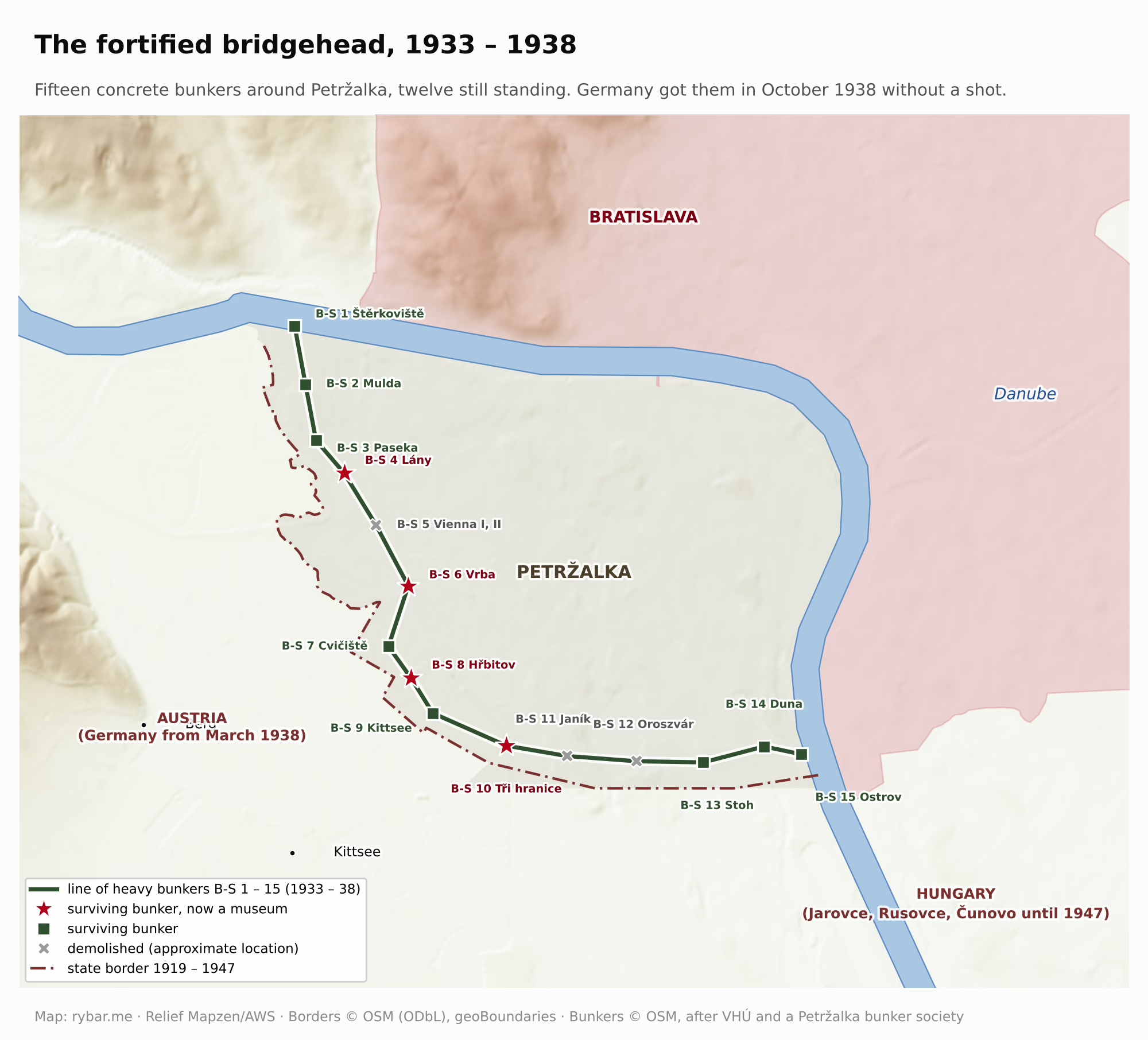
How fragile this position was became clear in 1938. Ten days after the Munich Agreement, on October 10, 1938, Germany occupied Petržalka and later Devín too, together about 40 km² with almost 15,000 residents. The bridgehead that was supposed to protect Bratislava became German territory with a view of Bratislava Castle. Engerau, as Petržalka was called again, became part of the Reich. The Reich thus got the bunkers meant to defend the bridgehead without firing a shot, and its soldiers trained in them.
Three weeks later the Vienna Award gave southern Slovakia to Hungary. The new border ran just a short way east of the city. Senec, 25 km from downtown, went to Hungary, so even the road from Bratislava to Nitra passed through foreign territory. When Bratislava became the capital of the Slovak State on March 14, 1939, it was a capital in a vise: Germany across the river, Hungary just to the east. On top of that, a protection treaty reserved for Germany a zone in western Slovakia where it could station its own garrisons.

The city also paid for the war because of its location. On June 16, 1944, American aircraft bombed the Apollo refinery, the Winter Harbor and the bridge, destroying 80% of the refinery. Depending on the source, between 176 and more than 200 people were killed. Bombs also hit downtown and Petržalka. More raids followed in September, October and December 1944 and in March 1945.
At the end of the war Engerau became part of the German Südostwall defense line. From December 1944, about 2,000 Hungarian Jews from a labor camp were made to dig an anti-tank ditch there, and at least 500 of them died. In the spring of 1945 the front came once again through the gate, along the Danube from the east. The retreating Germans blew up the bridge, and on April 4, 1945, the Red Army entered the city. Most of the bunkers survived the war. Only the double bunker B-S 5 was torn down to build the highway, and B-S 11 and B-S 12 to build the housing estate. The other twelve still stand. B-S 4 Lány by the crossing to Berg, B-S 6 Vrba and B-S 8 Hřbitov on Kopčianska Street are museums, and B-S 10 Tři hranice was recently restored.
After the war the bridgehead was returned, and in 1946 Petržalka became part of Bratislava. But Czechoslovakia wanted to push the border farther out. At the Paris Peace Conference in 1946 it asked Hungary for five villages: Čunovo, Jarovce, Rusovce, Rajka and Bezenye, together almost 147 km² with 7,523 residents according to the Hungarian census of 1930. Most of them were Germans and Croats; Hungarians made up about a fifth.
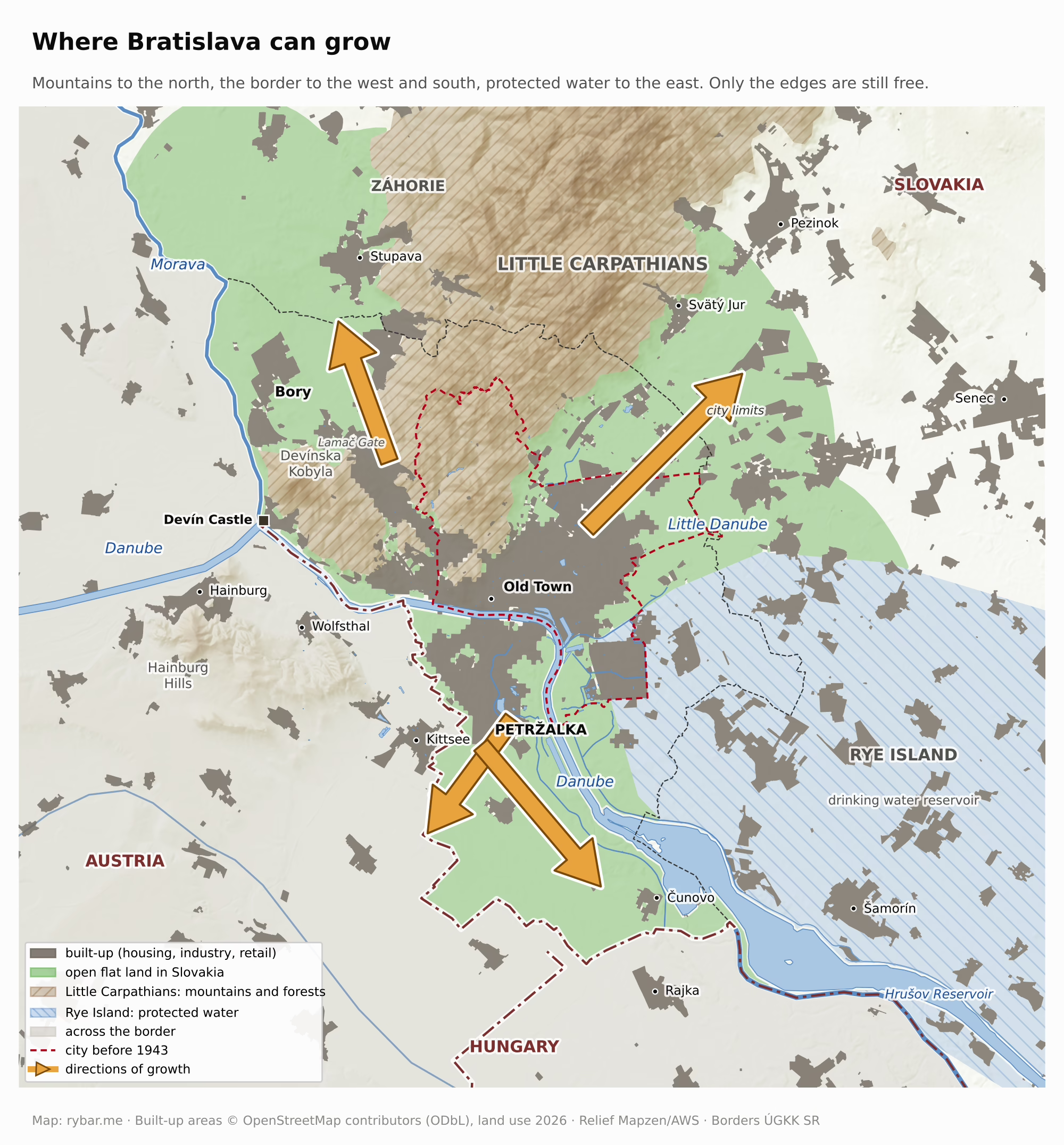
The reasons the delegation gave can be read straight off the map. First: the capital of Slovakia lies right on the state border. Second: Bratislava can only grow in this direction. To the north the Little Carpathians are in the way, to the west the Morava and Austria, to the east Rye Island with its precious groundwater reserves, and the only open flat land lies on the right bank. Third: expanding the port, the largest Czechoslovak port on the Danube, destroyed in the war, is also only possible here. Czechoslovak diplomats added that the city had been growing across the river until 1938 and had felt threatened on the right bank ever since. Hungary objected that the bridgehead already existed and that the villages were too far away for the city to need them. American diplomats found the request justified on economic grounds, but in their view five villages were too many.
The border would then have been about 25 km from Bratislava instead of about 6 km. Mainly because of US opposition, Czechoslovakia got only three villages. It took over Čunovo, Jarovce and Rusovce on October 15, 1947. Along with Rusovce, Slovakia also gained Roman Gerulata, and half a century later it built a dam near Čunovo that since 1992 has diverted the Danube into the Gabčíkovo canal.
Rajka and Bezenye stayed in Hungary. More Slovaks live in Rajka today than ever before, only this time they came of their own free will and without borders, as we will see at the end.

A capital that cannot be defended
The lesson of 1809 repeated itself several times over the next hundred and thirty years. In the summer of 1919 Hungarian troops stood at the far end of the only bridge; in 1938 the Reich looked down on the city from the other bank; and after the Vienna Award, Hungary began just past Vrakuňa and Podunajské Biskupice, about 7 km from downtown.
Every expansion of the city was therefore also an attempt to gain strategic depth: Petržalka in 1919, Jarovce, Rusovce and Čunovo in 1947. The border moved a few kilometers, but the depth the city would need cannot be gained this way. If both Austria and Hungary were hostile, the city could be shelled from two sides and would have no hinterland to fall back to. The state would then have to run the country from somewhere else, from the mountains in its middle. That is exactly what happened in 1944. When the uprising was being prepared, its center of gravity was not in Bratislava but in the Zvolen – Banská Bystrica – Brezno area. Why there, we will get to in the final part.
A housing estate by the barbed wire
After 1948 the gate closed completely. Yet in Slovakia the Communists did not win the free elections. In May 1946 the Democratic Party won clearly here, with about 62% of the vote, while the Communists got about 30%. The Communists did not accept defeat. In the fall of 1947 the security service they controlled invented an alleged anti-state conspiracy, arrested Democratic Party officials and weakened the party in Slovakia’s government. It was a dress rehearsal for a nationwide coup. In February 1948 the non-Communist ministers in Prague resigned, hoping to force early elections. But the Communists mobilized the armed People’s Militias, action committees and the unions, and on February 25 President Edvard Beneš accepted the resignations and appointed a government proposed by Klement Gottwald. In May 1948 voters could choose from only a single list. Nationalization followed, along with show trials of opponents and the destruction of the churches and the private economy.
After the coup, thousands of people fled Czechoslovakia across the border, and the regime decided to seal its border with the West. The Border Guard was ordered to prevent illegal crossings by all available means, and its rules allowed shooting at the border. The regime claimed the Iron Curtain protected the state from an external enemy, but in reality it was there to stop its own citizens from escaping. In 1949 the Financial Guard, which had guarded the border between the wars, was abolished, and the border began to be closed off with obstacles. The State Border Protection Act of July 11, 1951, declared a forbidden zone and a border zone along the border that could be entered only with a special permit, and from that year on it was lined by a barbed-wire barrier 15 to 20 meters wide with watchtowers, a strip of plowed earth and dogs. Along the entire 920 km border with Austria and Germany, almost 49,000 people were caught trying to cross it, and at least 280 civilians died there, 49 of them on the Slovak section.
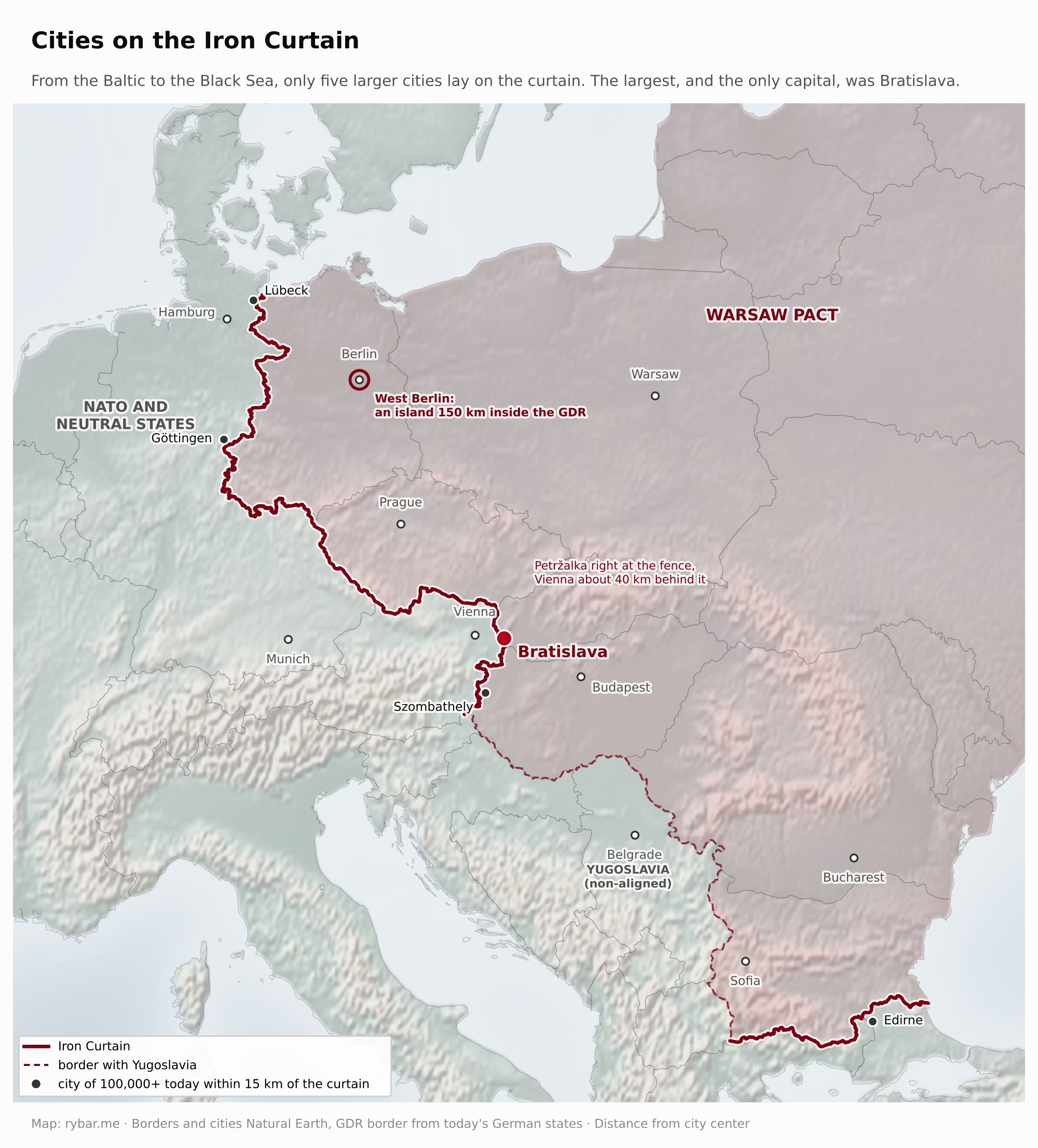
Bratislava was the only large city in Czechoslovakia right on the border with the West. There were not many such cities in all of Europe. From the Baltic to the Black Sea, apart from Bratislava only four larger cities lay within 15 km of the curtain: Lübeck, Göttingen, Szombathely and Turkey’s Edirne, and none of them was a capital. Vienna was about 40 km from the fence. Only Berlin had a similar fate, but it lay 150 km inside the GDR, and from 1961 its western part was ringed by a wall. Austria, visible from the castle, was as unreachable for Bratislava’s residents as America. People died trying to escape at Devín, in Petržalka, in Kopčany and in Jarovce. One of the victims was Hartmut Tautz, an eighteen-year-old from the GDR. On the night of August 8, 1986, he cut through the fence in Petržalka and ran across a cornfield toward Kittsee. The Border Guard’s dogs mauled him to death.
It was right here, by the fence, that the socialist state put the largest housing project in Slovakia’s history. After August 1968, when Warsaw Pact troops occupied the city and Soviet soldiers even moved into the castle, as we mentioned, Bratislava became the capital of the Slovak Socialist Republic in the new federation from 1969 and grew fast. It grew mainly thanks to industry. In the 1960s the refinery moved from downtown to the new Slovnaft complex at Vlčie hrdlo, and chemical and engineering plants expanded. The workers who came to them from all over Slovakia needed apartments. But where? The same argument applied that Czechoslovakia had used in Paris in 1946. To the north the city leans against the Little Carpathians, whose wooded slopes begin right behind downtown and are now a protected landscape area. To the west it is closed off by the Morava and the border. To the east begins the fertile plain of Rye Island, which sits on the largest reserve of drinking water in Central Europe, and the floodplain forests along the Danube. On the left bank the city could grow only in a narrow strip to the northeast, below the Little Carpathians toward Rača and Vajnory. The largest open area near downtown lay on the right bank: flat land with orchards, gardens and the low buildings of old Petržalka, just minutes from the Old Town, but right at the border.
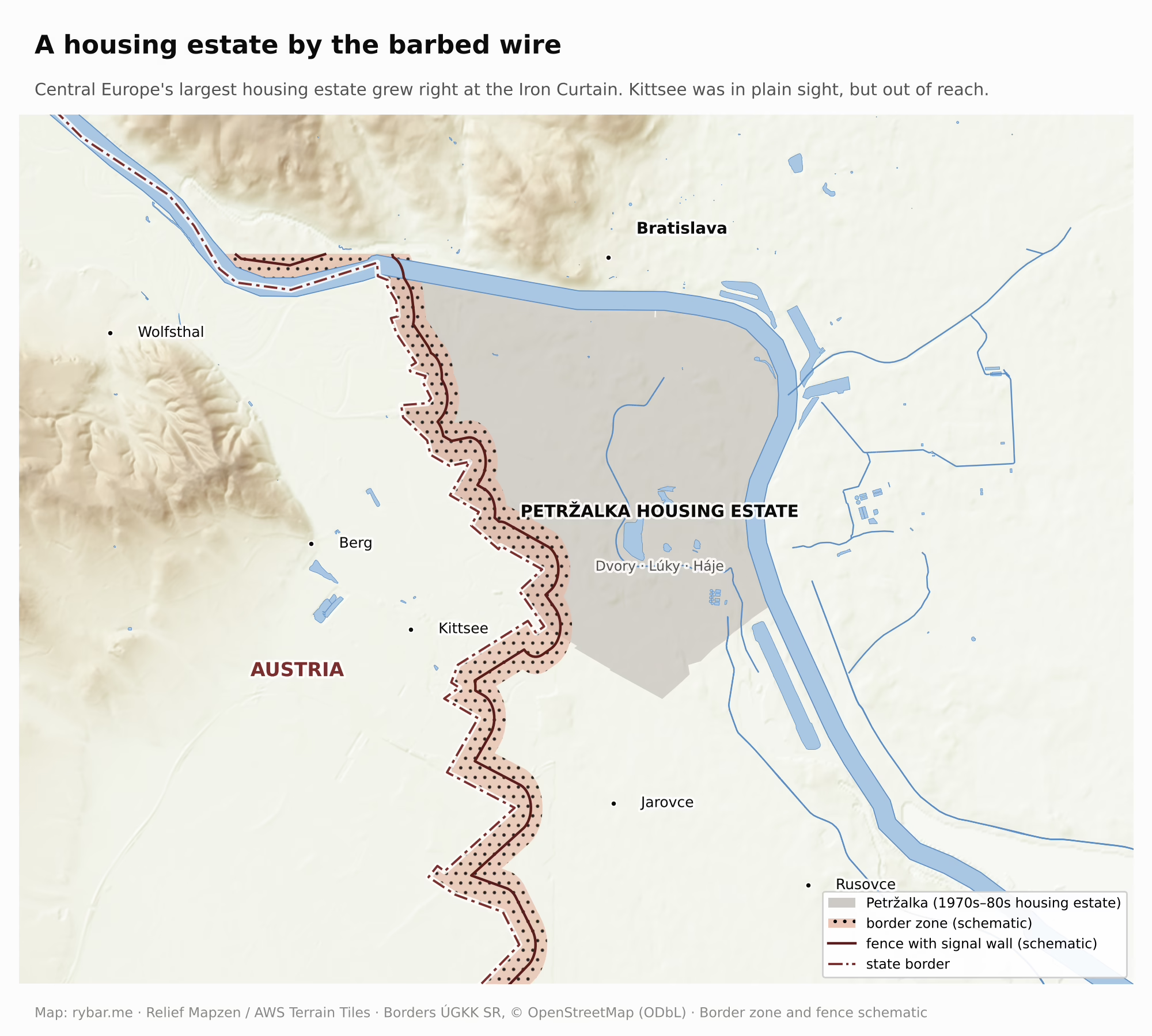
More than 80 teams from around the world entered the international architectural competition, but the winning designs were not used. The foundation stone was laid on April 2, 1973, on a square named Border Guards Square. The first apartment block was completed in 1977. In 1970 Petržalka had 14,064 residents; by 1991 it had 128,251. In twenty years roughly 140,000 people moved in, many from all over Slovakia, and the population grew by more than a hundred thousand. The result was the largest prefab housing estate in Central Europe, where people could see from their balconies Austrian villages they were not allowed to visit. After 1991 the population dropped slightly: the estate aged, young people moved out to the suburbs, and according to the borough government the 2011 census missed some residents. In 2021, 114,000 people lived here again.
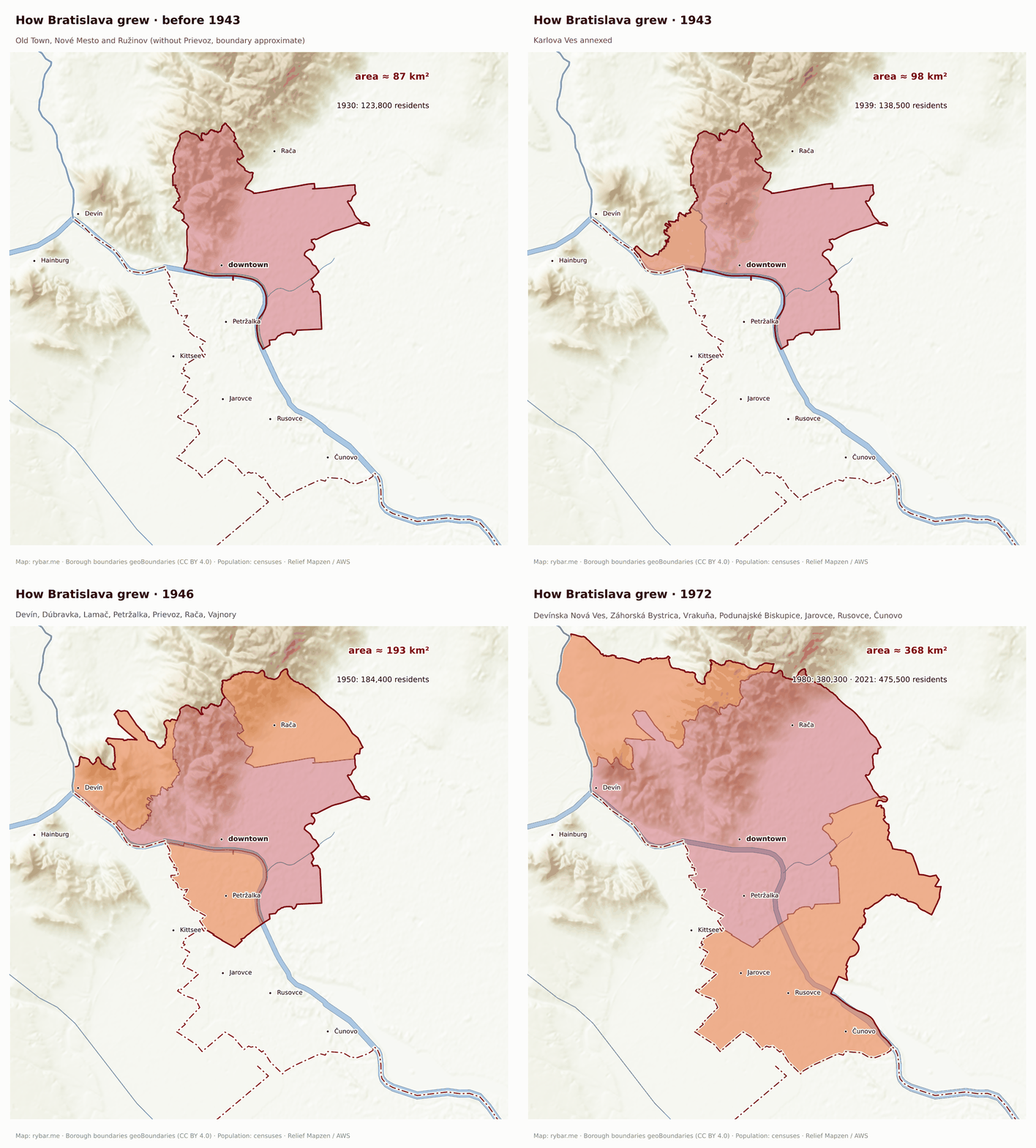
The city also grew by annexing the surrounding villages, because it could not grow across mountains and water. Karlova Ves was added in 1943; in 1946 Devín, Dúbravka, Lamač, Petržalka, Prievoz, Rača and Vajnory; and on January 1, 1972, seven more villages: Devínska Nová Ves, Záhorská Bystrica, Vrakuňa, Podunajské Biskupice, Jarovce, Rusovce and Čunovo. In thirty years Bratislava grew fourfold, from roughly 86 km² to today’s approximately 368 km².
The mountains and the river also complicate transport within the city. Bratislava is stretched out along the Carpathians and the Danube, and the river splits it in two. More than a hundred thousand people now live in Petržalka on the right bank, but when it was built only two bridges crossed the Danube. So from the 1970s a rapid transit line based on a metro was planned. It was not allowed to be called a metro, because under the rules of the time that was reserved for cities of a million. The first line was to run from Lúky through Petržalka, across the Danube on the Old Bridge and then under downtown to Obchodná Street and the main train station. The foundation stone was laid in 1988, but in 1990 construction stopped for lack of money. In 2003 the city shelved the metro and made trams the backbone of the system. In southern Petržalka a piece of tunnel and a half-built depot were left behind, and they gave way only to a new tram line. It has run across the Old Bridge since 2016, and since July 27, 2025, all the way to Janíkov dvor, from where the trip to Šafárik Square takes 12 minutes.
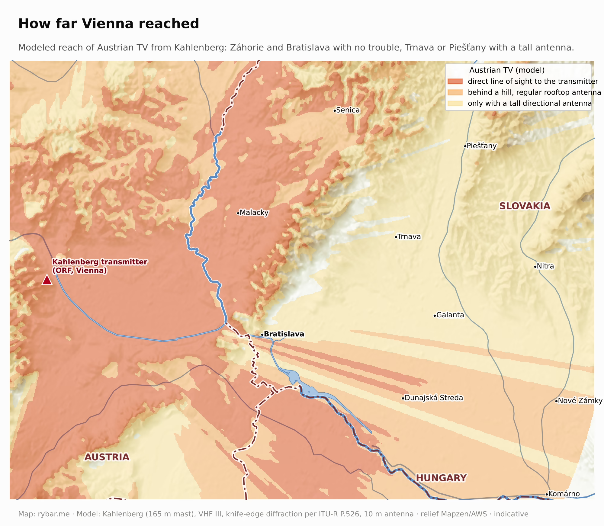
But the fence did not stop everything. Bratislava lay so close to Vienna that it could pick up Austrian television and radio. Austrian TV began broadcasting in 1955, when the signal from Prague did not yet reach Bratislava. So Bratislava residents secretly had their TV sets modified to receive Vienna, and local technicians charged 300 to 500, later up to 800 crowns for the job. When the authorities found out how many people watched Austrian television, they began jamming the signal. But the jamming also hit Austrian villages across the border, Austria protested officially, and Czechoslovakia soon stopped. By the 1980s, communal antennas on apartment blocks from Bratislava to Piešťany were pointed at Vienna, and according to people who remember it, this was tolerated. In April 1986, people in western Slovakia learned far more about the Chernobyl disaster from Austrian news than from domestic media. They saw Western news, ads, movies and music, and they knew how people lived a few kilometers away. The regime jammed foreign radio stations from 1952, at great expense. According to Radio Free Europe surveys, more than half of adult Czechoslovaks listened to Western radio. The jamming stopped only on December 9, 1988. ORF reporter Karl Stipsicz, who covered the Candle Demonstration on Bratislava’s Hviezdoslav Square in March 1988, later recalled that Bratislava had then seemed infinitely far from Vienna. For Bratislava residents it was the other way around: Vienna was on their screens every evening. This flow of information slowly eroded trust in a regime that claimed poverty and unemployment lay beyond the fence.
The gate opened again in December 1989. On December 4 Austria lifted visas for Czechoslovaks, and from December 8 they could travel to Austria without special permits. Two days later, on December 10, Public Against Violence organized a march from Bratislava to Hainburg. According to Austrian President Alexander Van der Bellen, more than 100,000 people crossed the border, and the people of Hainburg welcomed them with bread and salt. Ján Budaj greeted the marchers with words that became the motto of the era: “Hello, Europe!” The very next day, December 11, border guards near Devín began removing the barriers and wire fences.
The gate today
Since January 1, 1993, Bratislava has been the capital of an independent Slovak Republic. It is the only capital in the world that borders two countries. But since 2007, when Slovakia joined the Schengen Area, those borders can be crossed without stopping, and the city makes full use of that.
Bratislava is growing where it has always grown whenever the gate was open: onto the right bank and beyond. Kittsee, an Austrian village whose sign stands about 800 meters from Bratislava’s, is among the fastest-growing municipalities in Austria. In December 2025 it had 4,425 registered residents, and Slovaks outnumbered Austrians among them, 2,175 to 2,009. Berg and Wolfsthal are growing similarly. In Hungary’s Rajka, which Czechoslovakia asked for unsuccessfully in 1946, more than 5,500 people live today, and according to the news site Telex about 70% of them are Slovak citizens. Since October 2025 the village has charged anyone who buys property there a fee of 1.5 million forints. People are drawn by cheaper housing, a house of their own with a garden and a fifteen-minute drive to work.
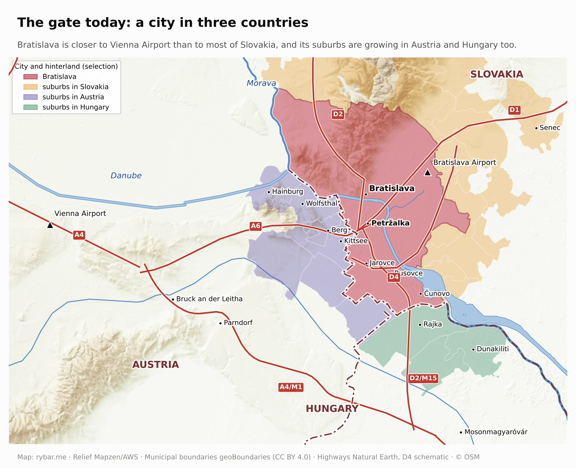
Bratislava’s natural hinterland thus lies in three countries. A capital that in 1919 was so afraid of the border that it seized a village across the river just to be safe now lives with the border as if it were a street. Where old Pressburgers used to say “Wir sind halt Pressburger,” today many residents of Kittsee and Rajka are Bratislavans too.
The geography that built Petržalka has not changed. The same argument applies as in Paris in 1946: the city is squeezed between mountains, a river, protected water and a border. New neighborhoods go up on the last open land, on former industrial sites, on the edges of Petržalka and on slopes where building is still possible. The city is also growing north, beyond the Carpathians. Through the Lamač Gate, a saddle between Devínska Kobyla and the main ridge of the Little Carpathians, a highway and a railroad lead to Záhorie, and the new neighborhood of Bory has grown up between Lamač and Devínska Nová Ves. Beyond it, development continues toward Stupava and Marianka. But the mountains narrow this direction into a tight corridor that everyone squeezes through in the morning.
The location that makes Bratislava vulnerable in war is its greatest advantage in peace. It lies on the Danube and on highways to Vienna, Budapest, Prague and Brno, it has its own airport, and under an hour’s drive away is Vienna Airport, one of the largest in Central Europe. So besides the carmakers from the first part, companies that need educated people close to a Western headquarters have come here too. IBM opened a shared services center in Bratislava in 2003 partly because it was close to its regional headquarters in Vienna. Dell runs some functions for Europe, the Middle East and Africa from here. AT&T, Amazon and dozens of others have centers here with thousands of employees. Such centers have become the third pillar of the economy after the auto and electronics industries. The rest of Slovakia does not have this combination of a river, highways, an airport and a nearby big city. That could change in the east. If Ukraine became a member of the European Union, and a finished highway and a modernized railroad led to Košice, Košice could become Slovakia’s second gate, this time to the east.
Morning commutes show how close the border villages are today. On a Tuesday at 7:30 a.m., according to Google Maps, the drive downtown from Austria’s Wolfsthal or Berg takes about 14 minutes, and from Kittsee 16 minutes. From Bratislava’s own Čunovo or Záhorská Bystrica it is 30 minutes, and from Senec 45 minutes. By public transit it is 20 minutes from Wolfsthal and 21 from Kittsee, 43 minutes from Rajka and over an hour from Vienna Airport.

Covid showed how fragile this is. In March 2020 there were border checks with Austria and Hungary again. Austria required a negative test, Hungary closed its borders to foreigners in September 2020, and when e-quarantine was introduced people waited at the crossings for dozens of hours. For thousands of people from the border villages, the trip to work, school or the doctor suddenly became a trip abroad. Without Schengen, it would be like that every day.
Wealth concentrates just as people do. In 2023 the Bratislava region produced 27.2% of Slovakia’s GDP, and its GDP per capita reached €45,187, twice the Slovak average. In purchasing power terms it stood at 153% of the European Union average in 2024, among the richest regions in Europe. What this means for a long, thin country whose capital lies in its westernmost corner, we wrote about in the first part.
The border drawn here in the 20th century is still a political issue today. On the anniversary of Trianon on June 4, 2026, Hungarian Prime Minister Péter Magyar said that Hungary is perhaps the only country in the world that “borders itself,” alluding to the Hungarians left outside its borders after 1920. In Slovakia his remark drew a wave of criticism. For Hungarians, Trianon is still a national trauma; for Slovaks, it is the beginning of their own state. Bratislava, the former coronation city of Hungary, lies exactly where these two views meet.
Two gates, two capitals on the edge
Now we can return to the question in the title. Capitals usually arise in the heart of a country, where most people live and where all roads lead. Bratislava arose differently. It is a gate city, and a gate is never in the middle. It is where one space ends and another begins. So Bratislava is not on the edge in spite of being the capital. It is on the edge because it is a gate city, and it became the capital precisely because of the advantages that gate gave it.
As long as it belonged to a large empire, the gate lay in that empire’s middle. For the Habsburgs, Vienna and Pressburg were two neighboring cities of a single monarchy, and the tram between them crossed the border without stopping. But when the basin and its rim were divided in 1918, the gate became a border. And both guardians of the gate from Pueyo’s sentence ended up on the edge: Vienna at the eastern end of Austria, Bratislava at the western end of Slovakia.
No other capital sits on the borders of two countries, but cities at tripoints do. Basel has grown across the borders of both France and Germany. Its three-country metropolitan area of almost 900,000 people is managed by a joint Eurodistrict, and about 70,000 people cross the borders every day. Germany’s Aachen, on the borders with Belgium and the Netherlands, lives similarly. These are all wealthy regions where, within the EU, the border helps more than it hurts. But none of them is a capital that has to run a whole state from its edge.
Bratislava did not become the capital because it was the Slovak heart. It became the capital because it lay on the Danube, had railroads, was the largest city and could be held. It became a Slovak city only afterward, during the 20th century, when Germans and Hungarians left or were expelled, Bratislava’s Jews were deported and murdered, and Slovaks from all over the country took their place. Today it is the largest Slovak city, yet it still stands where it stood two thousand years ago: at the gate, by the ford below the rock, with one foot in the basin and the other on its rim.
Answers
Why is Bratislava on the edge? Because it arose as the guardian of the gate between the Alps and the Carpathians, and a gate is always on a border. As long as it belonged to a large empire, it lay in the middle. When the monarchy collapsed in 1918, the border ran right through the gate, and Slovakia chose as its capital its largest city, with a port and railroads, even though it lay in the country’s westernmost corner. But it is on the edge only from Slovakia’s point of view. From Central Europe’s point of view it lies in the middle, 55 km from Vienna and 161 km from Budapest.
Why is Vienna three times closer to Bratislava than Banská Bystrica is? Because Bratislava lies at the western end of a long, thin country, right at the gate between the Vienna Basin and the Pannonian Basin. Its nearest neighbors are capitals, not Slovak towns. Budapest and Prague are both closer than Košice, because its own country stretches more than 300 km east, beyond the mountains.
Why is Bratislava the only capital that borders two countries? Because it stands where the Danube meets the Morava and where, in the 20th century, three successor states of the monarchy met. It has bordered both Austria and Hungary since 1919, and in 1921, when Austria got Burgenland, Austria also ended up south of Petržalka.
Why were Hungarian kings crowned here for 267 years? Because the Turks took the middle of the basin and the Habsburgs were left with only its rim. Pressburg was the rim’s city farthest from the front and closest to Vienna. Even after the Turks were driven out, the capital did not move right away, because Buda was in ruins and Vienna was close.
Why did only one in seven residents speak Slovak in 1910? Because for centuries the city at the gate was a German town in Hungary, which was rapidly Magyarized at the end of the 19th century. Slovaks lived mostly in the surrounding villages and in the mountains.
Why is the capital not in Martin, Žilina or Banská Bystrica? Because in 1919 the Danube, the railroads and the city’s size decided it. Bratislava was the largest, and it had a port and connections to Vienna, Budapest and Moravia.
Why does Petržalka belong to Slovakia? Because a city on a river cannot be defended without the other bank, as Napoleon showed back in 1809. The Czechoslovak army occupied it as a bridgehead in August 1919, and the peace treaties confirmed it. In 1938 Germany seized it for the same reason.
Why was Central Europe’s largest housing estate built by the barbed wire? Because a growing capital needed flat land near downtown, and on the left bank the Little Carpathians, the river and the protected water of Rye Island stood in the way. The only such land was on the right bank, in the bridgehead on the border.
Why do thousands of Bratislava residents live in Austria and Hungary today? Because the natural hinterland of a gate city lies on both sides of the gate. While the border was closed, it could not be used. Since Slovakia joined the Schengen Area, the city has been growing where it would grow without borders.
What’s next
This is the second part of a series on the geography and history of Slovakia. The first, Why Is Slovakia So Long and Thin?, explains the shape of the country. The final part will answer the question left hanging in both.
Why does Slovakia exist at all? For almost a thousand years we lived in Hungary without a country of our own, and as late as 1910 our future capital was German and Hungarian. Why didn’t Upper Hungary become part of Hungary, Poland or Czechia? How did mountains protect a language without a state for centuries? Why did the 1944 uprising start in the mountains of central Slovakia? And what changed in 1918, 1939 and 1993?
Sources
- Tomas Pueyo – Why Is Hungary So Small? (Uncharted Territories, 2024)
- Petržalka 1919 and the bridgehead: Kačírek Ľ. – 100 rokov pripojenia Petržalky k ČSR; Kačírek – Tišliar, Petržalka v rokoch 1919 – 1946; 1914-1918-online – Czechoslovak-Hungarian Border Conflict; Czech Embassy – anniversary of Petržalka joining Czechoslovakia; MV SR – Československé štátne hranice na území Slovenska 1918 – 1992; VHÚ – the Bratislava bridgehead question; Austria-Forum – Kittsee, Wolfsthal and Berg (AEIOU); schule.at – Die Veränderungen in Kittsee nach dem Fall des Eisernen Vorhangs
- Castle Hill and the ford: Digilib MUNI – the Danube ford and the settlement below the castle; Wikiwand – Bratislava Castle
- Capital in exile: Visit Bratislava – Hungarian Royal Chamber Palace; Tózsa-Rigó A., Historický časopis 2023; Captaincies of the Kingdom of Hungary (Pálffy 1999)
- Propeler: TASR – the Propeler is back; Modernism in Architecture – Propeller (1930)
- The capital debate: Kosaka N., Fedor Ruppeldt’s Arguments about the Capital City of Slovakia (2010); Buček – Plešivčák – Bačík, One hundred years of national capital-making (2024); The Economist – Why do countries move their capital cities?; REAL CORP 2025 – Success and Failure of New Cities
- Industry and bombing: Slovensko.sk – Petržalka; TASR – the raid on Apollo; TASR – Slovakia’s first air war, 75 years on; TASR – Bratislava bombed for the fifth time, 80 years on
- The 1944 uprising: Noviny.sk – “Start the evacuation”
- Service centers: SARIO – Shared Service Centres; The Slovak Spectator – Success stories: Shared services centres; The Slovak Spectator – Layoffs in business service centres
- Covid and borders: TASR – Hungary closes its borders; Noviny.sk – e-quarantine problems; Deník – Sousedé: Slovensko
- Basel: Kanton Basel-Stadt – Trinationaler Eurodistrict; Basel-Stadt – Living in Basel
- City growth: Wikipedia – Boroughs and localities of Bratislava; Act No. 63/1971; Wikipedia – Demographics of Bratislava
- Devín Gate and Devín: Wikipedia – Devín Gate; Wikipedia – Devín Castle; Visit Bratislava – Devín
- Distances: our own straight-line calculation between city centers
- Rome: Bratislava City Museum – Gerulata and UNESCO; Britannica – Carnuntum; Wikipedia – Meditations; Wikipedia – the Roman inscription in Trenčín; Roman legions – Marcus Valerius Maximianus; Wikipedia – Marcomannic Wars; Imperium Romanum – plans for the provinces of Marcomannia and Sarmatia
- The year 907: Wikipedia – Battle of Pressburg; Boba I., Braslavespurch: Bratislava or Zalavár? (1989); Galuška L., Brezalauspurc 907, Slovácko 2007
- Slavs and Great Moravia: Masaryk Museum – Mikulčice chronology; Wikipedia – Great Moravia; Wikipedia – Svatopluk I; Wikipedia – Carolingian Empire; Forum Historiae – Mojmirid Moravia on the empire’s border
- Castle Hill and archaeology: Slovensko.sk – history of Bratislava; TASR – castle excavations 2014; SAS Institute of Archaeology – Bratislava Castle 2018; Bratislavské noviny – a short history of the city; Historický zborník 2/2021 – Bethlen’s uprising
- The castle and Podhradie: Šimončičová Koóšová – Lesák, Zuckermandel – od Podhradia k mestskej štvrti Bratislavy, Archaeologia historica 2018; Wikipedia – Podhradie, Bratislava; Federmayer F., Šľachta uhorskej metropoly v pomoháčskom období; Gondová A., Bratislavský hrad a hradný kopec; Szalay P., O histórii diskusií o Bratislavskom hrade; e-obce.sk – history of Bratislava; Google Arts & Culture – the crown at Bratislava Castle 1608 – 1784
- Wine: Bratislava City Museum – Viticulture exhibition; Ius educilii and wine sales in Little Carpathian towns, Dějiny a dějepis; Lysá Ž., Wine production and consumption in medieval town law, Historický časopis
- The Danube, fish and floods: Noviny.sk – sturgeons in the Danube; TASR – the sterlet and migration barriers; Pannonhalmi M., Dunakiliti and the Iron Gates, the last beluga in 1958; Holčík J., Changes in the fish fauna of the Slovak Danube, Limnologica 2003; Pišút P., The 1787 Danube flood in Bratislava, Geografický časopis 2011; FAD STU – Bratislava Winter Harbor
- Hubert: Slovak Spectator – Legend versus reality; SPPK – sparkling wine production; Henkell Freixenet – history; Startitup – a 195-year-old winery
- River arms, bridges and regulation: Pišút P., Destruction of Petržalka by lateral erosion of the Danube, Geografický časopis 1993; Pišút P., The Croatian arm, Geografický časopis 1992; Bočková M., The reasoning behind the third Danube regulation by Lanfranconi, ALFA 2021; Slovak Spectator – Lanfranconi tamed the Danube; Monuments Board – origins of the Winter Harbor; Petržalka Library – That Was Petržalka
- Capital of Hungary and coronations: Habsburger.net – Pressburg: Capital in Exile; Britannica – Bratislava; TASR – coronations 1563 – 1830; Visit Bratislava – Coronations in Pressburg
- Uprisings: SME – calendar, Bethlen 1619 – 1621; Wikipedia – Gabriel Bethlen; Wikipedia – Peace of Pressburg (1626); Hungarian-Ottoman Wars – Thököly Imre; Wikipedia – Battle of Smolenice 1704
- Buda after 1686 and Joseph II: Budavár – The History of Buda Castle after 1686; Ságvári Á. (ed.), Budapest. The History of a Capital
- 1848: Wikipedia – April Laws; Britannica – March Laws; SME – calendar
- Napoleon: Špirko D. – Lupták M., Defense of the Bratislava bridgehead in the Franco-Austrian war of 1809, Vojenská história 2002; Čapo M., The 1809 war in the Capuchin chronicles, Vojenská história 2025; Wikipedia – Siege of Pressburg; Atlas Obscura – the cannonball in the Old Town Hall; Slovak Spectator – Napoleon in Petržalka
- 19th-century transport: Railtarget – the 1840 horse railroad; Wien Geschichte Wiki – Pressburger Bahn; imhd.sk – history of public transport in Bratislava; Novinky.cz – the Old Bridge
- Danube shipping, the flotilla and the port: Habsburger.net – The Danube flows in the wrong direction; Europeana – Travelling the Danube; Ardeleanu C., Travelling on DDSG steamers, Historical Yearbook 2009; Wikipedia – Šajkaši; Slovak Spectator – Komárno and the Danube flotilla; Wikipedia – Austro-Hungarian Danube Flotilla; GlobalSecurity – Hungarian Danube Flotilla; Taranaki Daily News 1930 – a century of Danube steamers; National Assembly – Danube shipping bill; National Assembly – 1922 shipping companies act; STM – 100 years of Dunajplavba; Kačírek Ľ., Etnologické rozpravy 2024 – Danube boatmen; SITA – the port of Bratislava and trains from China; Government Resolution No. 569/2024 – Port of Bratislava modernization; BusinessInfo.cz – port modernization; Perner’s Contacts – the Rhine – Main – Danube waterway; Gdynia Maritime University – energy use of water, rail and road transport; MARAD – barge, truck and rail car capacity; SITA – freight transport in Slovakia, Q1 2024
- Port cargo and freight costs: Bratislava Region – the county’s transformation during industrialization; Historical industrial structures of Bratislava (Hromádka 1943); STM Košice – Dunajplavba proceedings; Public Ports – history; Svet dopravy – Slovak inland ports; Denník N – Port of Stuttgart vs. Bratislava; WIFO 1962 – Danube port cargo in 1911 and 1937; Hajóregiszter – DDSG; Bogart D., The Transport Revolution in Industrializing Britain (2013); Historical Statistics of the United States – Df17-21; ICCT 2024 – Inland waterway transport (PLANCO 2007)
- Population and languages: Šedivý J., Linguistic and ethnic plurality in medieval Pressburg; Human Affairs 1996 – Bratislava 1850 – 1910; Habsburger.net – Pressburg 1910; JÚĽŠ SAV – Bratislava’s residents 1890 – 2008, “Wir sind halt Pressburger”; Mezei I., Urban development in Slovakia (2010); Luther D., Stories of a city that went from periphery to metropolis (SAS 2023)
- 1919: TASR – the occupation of Bratislava on Jan 1, 1919; Wikipedia – Bratislava Shooting (1919); Slovak Spectator – Bratislava on the brink of history; Radio Prague – The Czech invasion of ‘Wilson City’; TASR – county head Samuel Zoch; Nagayo – the name of the capital; Austrian History Yearbook – The Making of a Slovak City
- The occupation of Petržalka and Sokol: ČsOL – An uncertain Czechoslovak Bratislava; Bratislavské noviny – how Petržalka was occupied; Školské.sk – 100 years ago; Dnes24 – Šrobár and the bridgehead; TASR – Streets of Bratislava: bridges
- Burgenland 1921: Habsburger.net – Burgenland Is Gained
- 1938 – 1947: ÚPN – the founding of the Slovak State; Wikipedia – Bratislava bridgehead; Central European Papers 2013 – Petržalka and Devín 1938; Central European Papers 2019 – the five villages in 1946/47; FRUS 1946, vol. IV – the Czechoslovak claim and its reasons; FRUS 1946, vol. III – negotiations in Paris; Christchurch Press 1946 – Hungarian objections
- The Communist coup: ÚPN – February 1948; ÚPN – Slovakia’s February, fall 1947
- Foreign broadcasts: ÚPN – Foreign radio broadcasts into Czechoslovakia; Minulost.cz – a disinformation war against its own people; Slovak Spectator – an ORF reporter on the Candle Demonstration; Oldradio – ORF 1955
- The Iron Curtain: ÚPN – the Iron Curtain in numbers; ÚPN – state border protection; Slovak Spectator – remnants of the fence; Petržalka Library – Life on the Iron Curtain; Noviny.sk – Hartmut Tautz; Karner S., Halt! Tragedies at the Iron Curtain (ÚPN 2015)
- The Petržalka housing estate and city growth: TASR – 50 years since construction began; Mládek et al., Geografický časopis 1998 – Petržalka’s population; Noviny.sk – the architectural competition; Bratislava District Office – area analysis (Little Carpathians PLA, Rye Island); Bratislava zoning plan – background (Rye Island water protection area, PLA)
- Bratislava as capital of the Slovak Socialist Republic: Slovak National Council Act No. 43/1968 on Bratislava, the capital of Slovakia
- December 1989: ÚPN – Jašek P., Hello, Europe!; RSI – memorial plaque in Hainburg
- Rajka, Kittsee, ORF and the Jews of Podhradie: Telex – Rajka and its newcomers (2024); Telex – the Rajka fee (2025); SPÖ Kittsee – Jahresrückblick 2025; Pravda – Jancura V., How Slovaks humanized Czechoslovak Television (2023); Trnavské rádio – antennas aimed at Vienna; Trnavské rádio – ORF and Chernobyl; Yad Vashem – the Jewish community of Bratislava
- Today: Der Standard – Kittsee and Bratislava; Austria-Forum – Kittsee; Daily News Hungary – Slovaks in Rajka; Hungarian Geographical Bulletin 2021 – cross-border suburbanization
- GDP: Statistical Office of the SR – Bratislava Region; Eurostat – regional GDP
- Trianon 2026: Noviny.sk – PM Magyar’s remark draws criticism in Slovakia
- Petržalka fortifications: TASR – Petržalka’s bunkers were a unique defense of Czechoslovakia; Dubánek M. – Infantry bunker B-S 13 (Vojenská história 2008); Slovakia.travel – Petržalka Fortification Museum
- The Engerau camp: TASR – Ľ. Kačírek: there was a Nazi camp in Petržalka too; Kuretsidis-Haider C. – Das Lager Engerau (DÖW 2021)
- Demolition of Podhradie: The Slovak Spectator – The changing face of Bratislava; Wikipedia – Podhradie, Bratislava
- Metro and tram: Petržalka Library – building the rapid transit line; Startitup – demolition of the metro depot; TASR – tram to Janíkov dvor from July 27, 2025
- Devín Castle: Bratislava City Museum – Devín Castle (leaflet); TASR – Streets of Bratislava: Devín Castle
- Transylvania as an Ottoman vassal: Britannica – Hungary, the period of partition; Wikipedia – Principality of Transylvania (1570–1711)
- Demolition of the walls: The Slovak Spectator – Bratislava city walls; Hrnčiarová – Korabinský’s map of Bratislava (Geografický časopis)
- Towns in 1910: Wikipedia – Ethnic and religious composition of Austria-Hungary; Czech Statistical Office – Historical Lexicon of Municipalities, Brno
- Bridges and Danube crossings: Beliana SAS – Bratislava’s bridges; Wikipedia (Slovak) – Water Tower (Bratislava); TASR – Streets of Bratislava: bridges
- Surviving bunkers: oma.sk – military bunkers in Petržalka (OpenStreetMap); TASR – bunkers on the Bratislava bridgehead; Archiweb – Bunker B-S 10
- The Štúr circle at Devín: TASR – the memorable 1836 outing to Devín
- Towns in 1910: 1910 census recalculated to today’s municipal boundaries; Iron Curtain and cities: Natural Earth (our own distance calculation)
- Austrian TV reach: Sender Kahlenberg (129 m mast from 1956, 165 m from 1974); diffraction model per ITU-R P.526
All maps and charts are our own (rybar.me), made from public data: elevation data Mapzen / AWS Terrain Tiles, Natural Earth (public domain), borders ÚGKK SR and water © OpenStreetMap contributors (ODbL license). Other sources are given under the images.