This article was originally published in Slovak: Prečo je Slovensko také dlhé a úzke?
In October 2021, something Slovakia had waited fifty years for finally happened: a continuous highway connected Bratislava and Košice. It just doesn’t run through Slovakia. It runs through Hungary.
Why does the first highway between our two largest cities go through a neighboring country? Why is Slovakia 428 km wide but only 195 km tall? Why do almost all our rivers flow south? Why does it rain two to three times more in the Tatras than on Rye Island? Why were there only two decent railroads connecting us with the Czech lands in 1918? Why do people from Záhorie and Šariš speak so differently? Why is the Bratislava Region more than three times richer than the Prešov Region, when the mountains were once the richest part of the country? And where did a piece of the republic in the east go?
All these questions have one answer. It’s on this map.

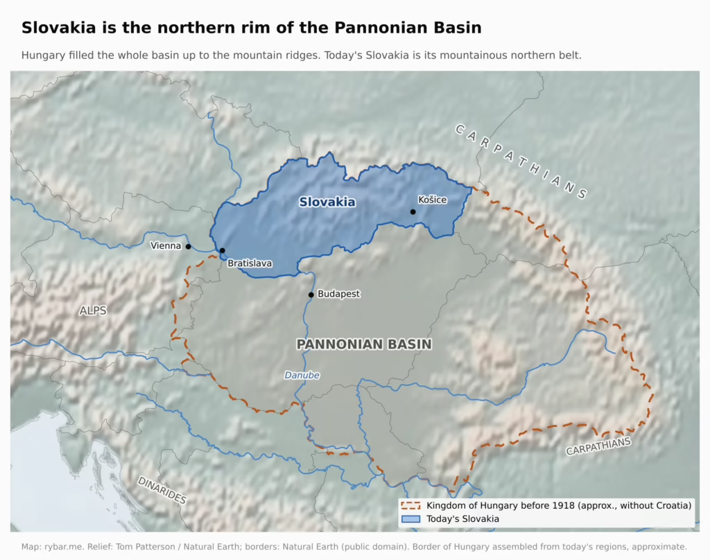
The Rim Around the Basin
In the middle of Central Europe lies a huge plain surrounded by mountains: the Pannonian Basin. In his article Why Is Hungary So Small?, Tomas Pueyo shows that this basin explains almost everything about Hungary: the plain in the middle is fertile, and the mountains around it form a natural wall.
Slovakia is the other side of the same coin. We are not the basin. We are its northern rim.
Look at the border of old Hungary on the map. For almost a thousand years it filled the whole basin up to the mountain ridges, and today’s Slovakia is the mountain belt along its northern edge. That is where our shape comes from. A rim is long and thin. From Záhorská Ves to Nová Sedlica it is 428 km; from Štúrovo to Slatité only 195 km.
Lowlands make up about 28% of Slovakia. The rest is mountains and the basins between them. And our longest border is not with the Czechs, with whom we shared a state from 1918 to 1992 with a wartime break, but with Hungary: 654.8 km according to Slovak authorities.
All the Water Flows South
Mountains don’t just decide where people can live. They also decide where water flows. And where water flows, people and trade follow.
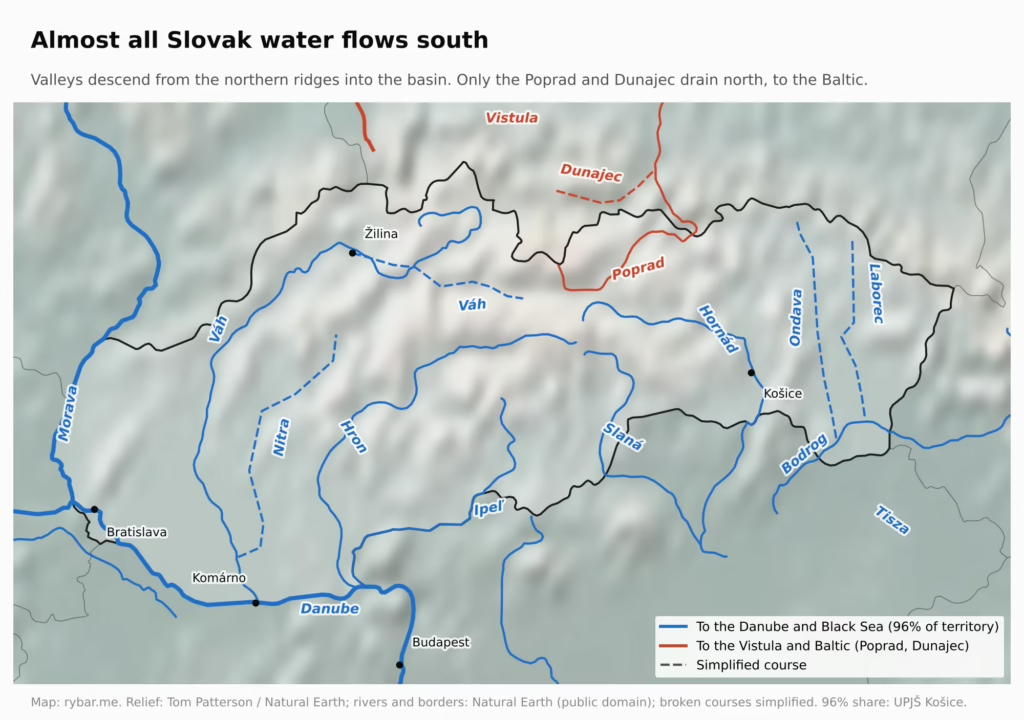
The Váh rises below the Tatras and flows into the Danube at Komárno. The Hron enters it opposite Esztergom, the Ipeľ near Szob in Hungary. The Hornád, Ondava and Laborec head for the Tisza. Almost every Slovak river eventually meets the Danube, and thanks to it almost every one ends in the Black Sea. Water from 96% of Slovakia drains into the Danube.
Only the Poprad and the Dunajec drain to the Baltic, via the Vistula. The main European watershed runs along the ridges in the north, and the best place to see it is the Sub-Tatra Basin. Its western part belongs to the Váh and the Black Sea, its eastern part to the Poprad and the Baltic.
The map shows it clearly: almost all of Slovakia is blue, the color of the Danube. Only a small patch in the north below the Tatras is red.
Here is the key point: our valleys don’t run from west to east, but from north to south, toward Hungary. Throughout history, someone who wanted to get from Liptov to Nitra usually didn’t cross the mountains. They went down the valley to the plain. Košice grew up on the Hornád, on the trade route from Hungary to Poland.
Rain, Mountains and Sheep
The mountains decide not only which way rivers flow, but also where it rains. Most of Central Europe’s rain comes with westerly winds from the Atlantic, less of it with moist air from the Mediterranean. The Pannonian Basin is ringed by the Alps to the west, the Dinarides to the south and the Carpathians to the north and east. Air rises over them, cools and drops its rain, so it reaches the middle of the basin already dried out. That is why the plain in central Hungary and our south are among the driest places in Central Europe.

Slovakia shows the same thing on a smaller scale. Air from the northwest hits the Beskids, the Fatra and the Tatras, which get 1,200 to over 1,500 mm of precipitation a year. Rye Island (Žitný ostrov) and the area around Komárno, which already lie in the basin, get only 500 to 600 mm.
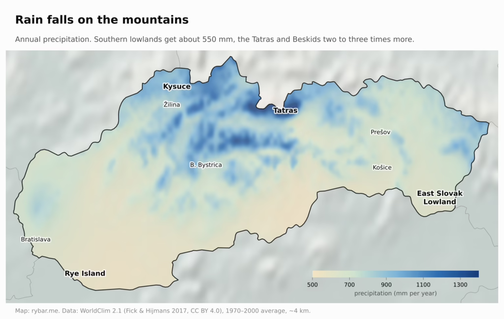
Water from the mountains then flows in rivers south to the drier plain. Below Rye Island, the Danube and its tributaries have created the largest natural reservoir of groundwater in Central Europe.
Temperatures differ in the same way. The average annual temperature is around 10 °C on the Danubian and East Slovak Lowlands, around 6 °C in the basins of Orava, Liptov and Spiš, and below zero on the Tatra ridges. Every hundred meters of altitude takes away roughly 0.6 °C, and with it days when anything can grow. The extremes differ even more. In July 1970–2000, the lowlands in the south had an average daily maximum of about 26–27 °C, the basins below the Tatras about 22 °C. In January, the nighttime minimum in the northern basins fell to −8 °C on average, in the south only to −3 or −4 °C.

Warmth and water decide what can be done where. The warm, drier south is a breadbasket of wheat, corn, sugar beet and vineyards. The cold, wet north, with thin soil on its slopes, is a land of forests and pastures. Slovakia carries the difference between plains farmers and mountain shepherds within itself. From the 14th to the 17th century, shepherds came into the mountains in the so-called Wallachian colonization. They moved from east to west along the Carpathians and brought sheep farming on mountain salaše (shepherds’ huts with summer pastures), and with it bryndza, the sheep cheese. According to ethnologists, bryndza was made all over Slovakia except the lowland southwest and parts of the east, where Carpathian sheep farming never reached. After the Wallachians came the kopaničiari, settlers who in the 17th to 19th centuries cleared forest on the slopes of Myjava, Kysuce and Podpoľanie and won their fields piece by piece.
Where it’s warm and flat and there is water, most people live. About 41% of Slovakia lies below 300 meters above sea level, including low valleys and basins besides the lowlands, yet roughly two thirds of the population live there. More than a third of the country lies above 500 meters, and only about 12% of people live there. That is why a population density map looks like a map of rivers: people concentrate in the lowlands and in the valleys of the Váh, Nitra, Hron, Hornád and Torysa, with almost empty mountains in between.

The whole country rests on this pattern: a breadbasket on the warm plain, most people in the lowlands and valleys, forests and pastures in the cold mountains. But the maps above show the climate normal of the last century, and it no longer holds. In Hurbanovo, where measurements began in 1872, the average annual temperature rose from 9.4 °C around 1900 to 11.2 °C over the last 30 years. According to the Slovak Hydrometeorological Institute (SHMÚ), summer 2026 was the third warmest since 1931. On August 6, Dolné Plachtince near Veľký Krtíš recorded 42.2 °C, the highest temperature ever measured in Slovakia; the day before, Kamenica nad Hronom hit 41.4 °C. The records didn’t fall on the lowest plain, but in warm basins and valleys in the south, where hot air gets trapped. Even Štrbské Pleso, at about 1,350 meters, had a tropical day with 30.2 °C, and Holíč had 16 tropical nights.
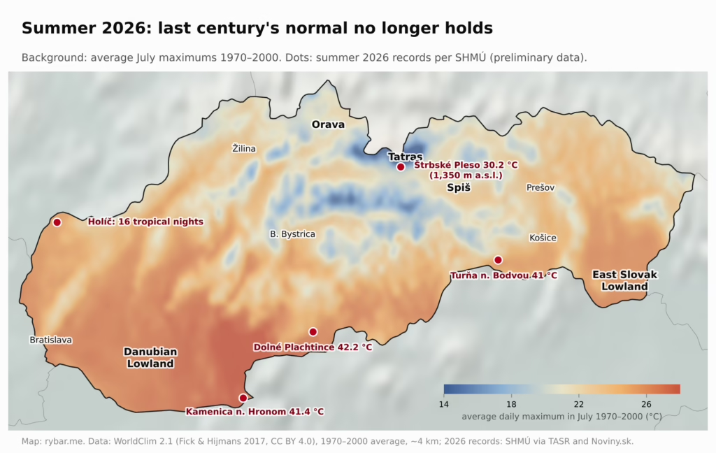
Heat is not just a discomfort. People cool down by sweating, and when it stays hot at night, the body doesn’t recover. SHMÚ climatologists consider an average daily temperature of 27 °C the threshold at which heat starts to harm even healthy people. For centuries, the warm south was an advantage for harvests, but in summer it is becoming an ever greater burden for people.
For a country built on the difference between a warm plain and cold mountains, this could be a turning point. The breadbasket in the south needs water, yet the Danubian Lowland gets the least rain, and Rye Island, our largest groundwater reservoir, is the area most threatened by drought. The south, where most people live, will be increasingly hard on people and crops in summer. The higher basins in the north are warming too, but in summer they stay several degrees cooler and have more water. According to climatologists, the growing season in Slovakia has already lengthened by 20 to 30 days. The basins below the mountains could become a refuge from the heat and a new space for farming. Geography that favored the plain for centuries may slowly be turning around.
Why We Were Part of Hungary for a Thousand Years
The direction of rivers and valleys also explains something often overlooked in Slovak history. That we belonged to the Kingdom of Hungary for almost a thousand years was neither an accident nor a cruel twist of fate. The rim and the basin form one geographic whole: whoever controlled the plain in the middle also controlled the valleys that open onto it. An independent Slovak state is therefore a modern thing. It could only emerge in the 20th century, when this whole fell apart.
The mountains divided not only the land, but also the people. The Magyars arrived around the turn of the 9th and 10th centuries as nomads and settled on the plain, which suited them. The Slavic population held on mainly in the mountain counties of the north. The original language border lay further south and shifted during the Ottoman wars, but to this day it roughly follows the line where the mountains turn into plain. A Hungarian community lives in a continuous belt along the southern border. In the 2021 census, 422,000 people, 7.75% of Slovakia’s population, declared Hungarian ethnicity, and in the Trnava and Nitra regions more than a fifth of people have Hungarian as their mother tongue.

Before 1945 the south was far more Hungarian. After the war, Czechoslovakia stripped Hungarians of citizenship under the Beneš decrees. In a population exchange it expelled 89,660 people to Hungary, while 73,273 Slovaks came from Hungary. Tens of thousands of people were sent to forced labor in the Czech lands, and 326,679 went through so-called re-Slovakization, an official change of ethnicity to Slovak. Today’s ethnic map of the south is thus a product of both geography and 20th-century politics.
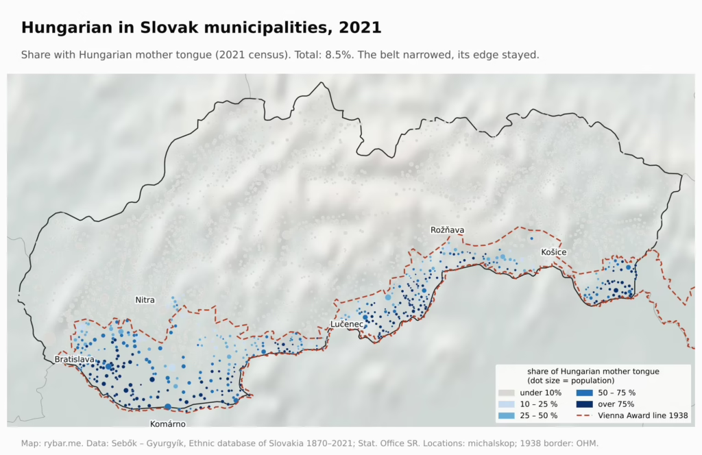
The maps show both states, municipality by municipality. In 1910, 30% of the population of today’s Slovakia gave Hungarian as their mother tongue; in 2021 only 8.5%. The 1910 figures should be read with caution: the Hungarian census took place at the height of Magyarization, and Slovak demographers point to so-called statistical Hungarians, especially in cities like Košice and Bratislava. The picture is still clear. Hungarian-speaking municipalities lay almost exclusively on the plain and at the foot of the mountains, where the valleys open into the basin. Over 110 years this belt has narrowed: it has nearly disappeared around Nitra and Košice and weakened near Rožňava, but its northern edge still follows the same line. That line is also where the border was drawn in 1938: in the negotiations, the Hungarian side demanded a border based on the 1910 census, and the line of the Vienna Award (dashed on the maps) almost matches the language border.
The Rails Led to Budapest
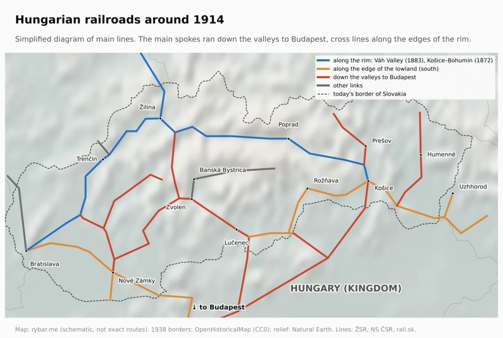
In the 19th century the railroad arrived, built by people for whom Budapest was the center of the world. By the end of the century, the main Hungarian lines formed a star-shaped network around the capital. The spokes ran from Budapest to every corner of the kingdom, including up the Slovak valleys.
But the spokes alone were not enough. Hungary also needed connections across, from west to east, and those could only run where the terrain allowed. There were two options. The first ran along the southern edge, where the mountains break into the plain: the line from Bratislava through Galanta and Nové Zámky to the Danube, and the Gemer line from Zvolen through Lučenec, Fiľakovo and Rožňava to Košice. The terrain here was flat and construction cheap. The second ran inside the rim, along a chain of basins that the Váh and Hornád link through narrow passes: the Váh valley, Turiec, Liptov and Spiš. This was the route of the Košice–Bohumín Railway, completed in 1872, which linked Košice with the Silesian coalfields through the valleys of the Hornád, Váh and Kysuca, and of the Váh Valley Railway from Bratislava to Žilina, finished in 1883.
This difference later proved fateful. The lines on the edge of the lowland lay exactly in the belt where Hungarians lived and where 20th-century borders were drawn. The line through the chain of basins lay deep in the mountains, on Slovak territory. That is why the Košice–Bohumín Railway became Slovakia’s backbone, and a hundred years later the D1 highway would follow the same chain of basins. The north–south lines that ran down the valleys to Budapest, by contrast, lost their purpose the moment Budapest ended up behind a border. And the junctions where the spokes met the southern cross line, such as Komárno, Nové Zámky, Lučenec and Košice, lay on the edge of the lowland. In 1938, they were what was at stake.
1918: A Country That Had to Be Stitched Together
Then came 1918 and a new state. Czechs and Slovaks found themselves in one republic, yet their lands were barely connected. When Czechoslovakia was founded in October 1918, only two decent railroads linked Slovakia with the Czech lands: the private Košice–Bohumín Railway, which took a detour through Bohumín, and the mountainous Vlára Pass Railway from Trenčianska Teplá to Brno. Besides them there were three weak local lines in Záhorie. One Slovak deputy summed it up in parliament in 1919: anyone who wanted to go to Bohemia had to go either via Bohumín or via Vlára, “and that is inadequate.”
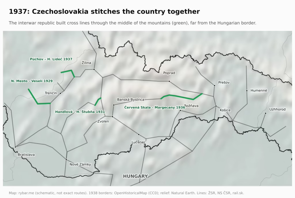
Interwar Czechoslovakia therefore launched a large construction program. It built lines meant to connect the country from west to east. In 1931 it opened the Handlová – Horná Štubňa line, and on July 26, 1936, the mountain line Červená Skala – Margecany, still one of the most beautiful in Slovakia. Toward Moravia, the lines Nové Mesto nad Váhom – Veselí nad Moravou (1929) and Púchov – Horní Lideč (1937) were added. In 1936, construction also began on the Banská Bystrica – Dolná Štubňa link. Together with the Handlová – Horná Štubňa and Červená Skala – Margecany lines, it was to form a new cross axis through the middle of the country: from Trenčín through Prievidza, Handlová, Banská Bystrica and Margecany to Košice, far from the Hungarian border. Roads had to be reoriented too: from north–south, toward Budapest, to west–east.
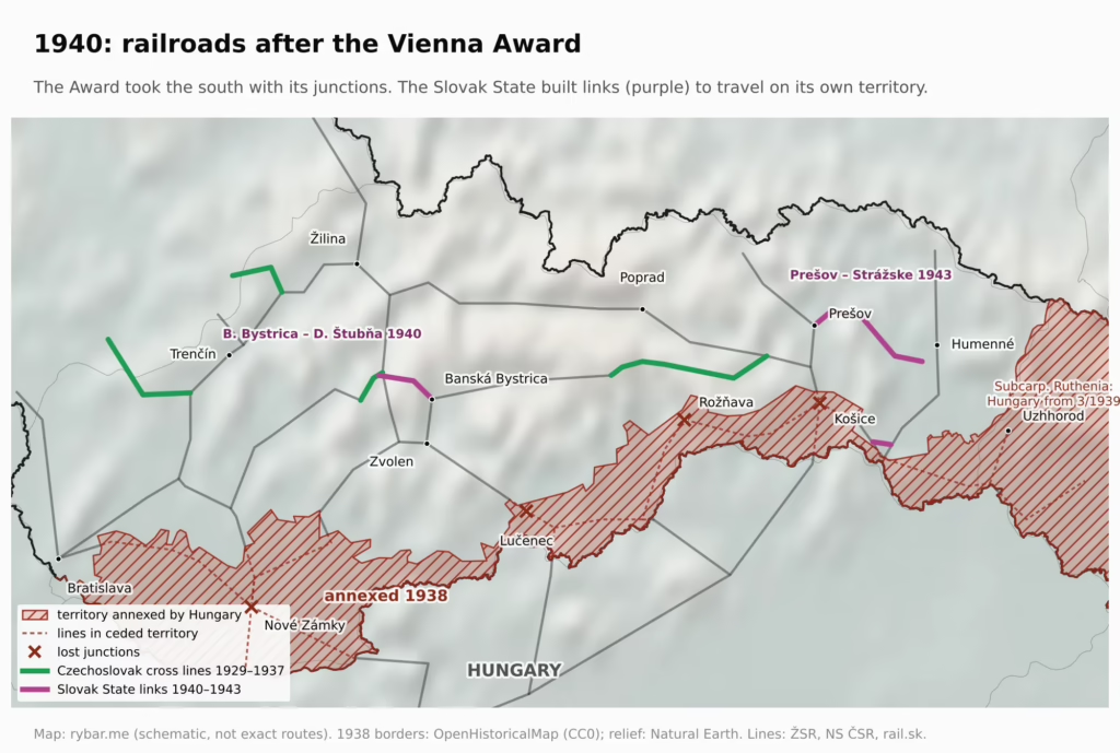
Twenty years later it became clear how fragile this stitching was. The Vienna Award of November 2, 1938, gave Hungary the south of Slovakia, including Košice, Levice and Lučenec: 10,390 km² with more than 850,000 inhabitants. The new border cut the main west–east roads and railroads. Slovakia lost about a third of its lines and the railroad junctions of Komárno, Nové Zámky, Lučenec, Rožňava and Košice. Without Košice, the only way to get by train from Prešov to Humenné and Michalovce was in transit through Hungarian territory. The Gemer lines north of the new border became dead ends reachable only through Hungary, and even the road from Bratislava to Nitra ran through Senec, which went to Hungary. The Slovak State hastily built replacement links: the Tomášovce – Vidiná – Veľká Ves connection; in 1940 it completed the Banská Bystrica – Dolná Štubňa line; and above all the line from Prešov to Strážske, which from September 5, 1943, again connected Prešov with Humenné and Zemplín without crossing Hungary. The pre-Award borders were de facto restored in 1945 and confirmed by the Paris Peace Treaty in 1947.
This may be the most important sentence in this whole article: Slovakia is not a natural west–east corridor. It is a country that had to be stitched together. And we are still stitching it today.
A Country of Regions and Dialects
It wasn’t only the territory that had to be stitched together, but also the people. Before 1918, Slovakia did not exist as a territory with borders. According to historian Dušan Kováč, it got administrative borders for the first time in history only in Czechoslovakia. Until then, people lived in Hungarian counties: Trenčín, Orava, Liptov, Spiš, Šariš. Many of them matched a single basin or valley enclosed by mountains, and almost all of life happened within it. Home meant the region, not the country.
Language is divided the same way. Dialectologists distinguish three groups of dialects, West Slovak, Central Slovak and East Slovak, and about 25 dialects within them. Most are named after former counties, such as Orava, Trenčín or Spiš, or after geographic areas, such as Záhorie and Trnava. Linguists point out that dialect boundaries largely match the boundaries of the old counties. The explanation is geographic: settlement was fragmented, and smaller areas, separated first by mountains and later by county lines, lived fairly isolated, so their speech developed on its own.
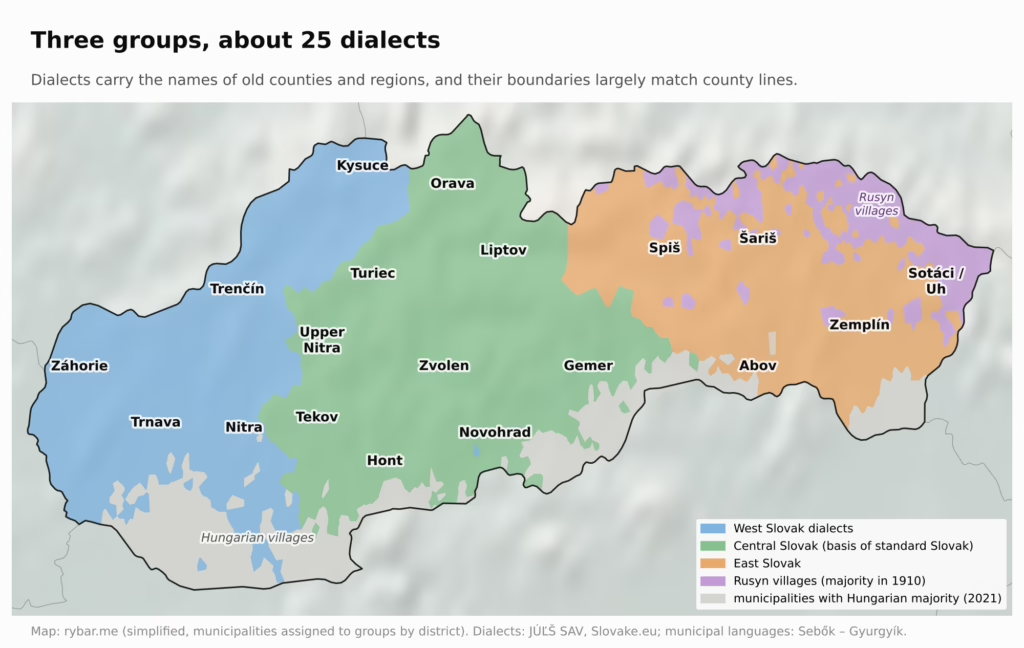
The differences are not small. East Slovak dialects are closer to Polish and Rusyn, the Záhorie dialect to Czech. Standard Slovak was created twice, each time from a different part of the country. In 1787, Anton Bernolák based it on West Slovak dialects. In 1843, Štúr, Hurban and Hodža based it on Central Slovak, which they considered the most widespread and therefore the most acceptable. The speech of the center thus became the standard. Historian Alexander Maxwell even argues that the very division into three dialect groups reflects Štúr’s effort to unite Catholics and Lutherans more than linguistic reality.
Over the centuries, more layers were added to this mosaic, always depending on which way people could come. After the Mongol invasion of 1241, Hungarian kings invited German colonists. They settled mainly in the mining towns of central Slovakia, where the German language island of Hauerland formed around Kremnica and Handlová, and in Spiš. The Wallachians we mentioned earlier were at first mostly Romanians, later mainly Rusyns, and their trace is the Rusyn villages in the northeast to this day. In the 16th century, Croats fleeing the Ottomans settled in western Slovakia; their descendants live in Devínska Nová Ves, Jarovce, Čunovo and Chorvátsky Grob. And the south, as we have seen, belonged to the Hungarians.
In 1910, of all the inhabitants of today’s Slovakia, 58% had Slovak as their mother tongue, 30% Hungarian, 6.7% German and 3.4% Rusyn. In Bratislava, German was still the most common language that year, spoken by 42% of the population.
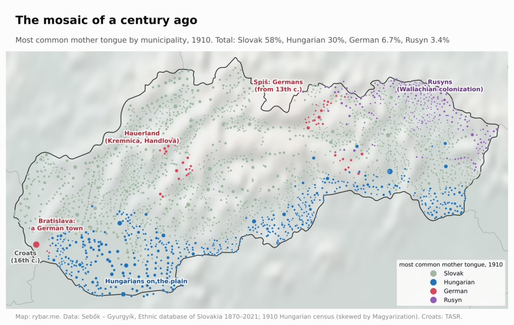
The 20th century swept away most of this mosaic. In 1930 there were 136,737 Jews in Slovakia by religion. About 70,000 Jews were deported from Slovakia, and most of them died in Nazi camps. In 1941 there were still more than 143,000 Germans. Evacuation, expulsion and repression reduced their number by about 95%. We have already written about the Hungarians and the Beneš decrees.
At the same time, the country really was stitched together. The First Republic gave Slovakia borders, Slovak schools and offices, and new cross-country railroads that for the first time connected regions across the mountains. Today’s historians say that this was when even nationally lukewarm Slovaks, for example in the east, fully embraced a Slovak identity. After World War II came industrialization and migration to cities, and according to dialectologists, dialects began to change quickly, faster in cities than in the countryside. Modern Slovakia, then, was not created only by a standard language and a national revival. It was also created by the railroads, roads and schools that turned a country of regions into one country. But the differences have not disappeared. Dialectologist Martin Smatana says that at Bratislava’s main train station, even a layperson can tell who came from Záhorie, who from around Banská Bystrica and who from the east.
Where Did the East Go?
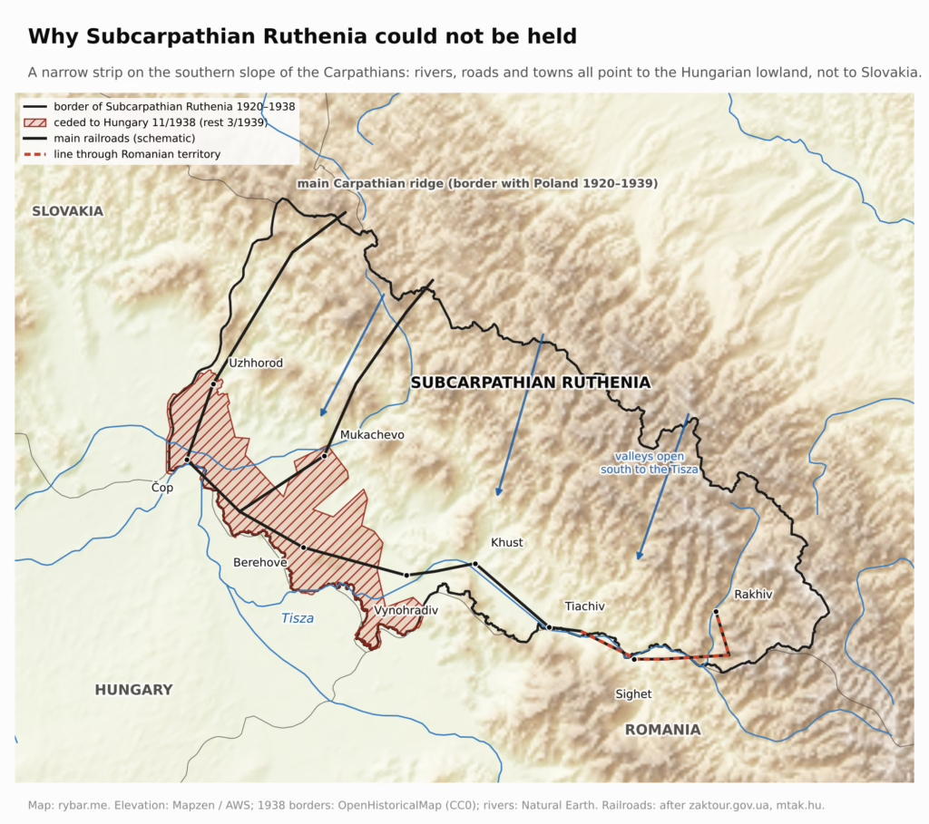
The interwar republic reached even further east, through Subcarpathian Ruthenia all the way to Romania. That land was even narrower than Slovakia and lay entirely on the southern slope of the Carpathians. Its valleys opened south onto the plain along the Tisza, and the main railroad to it ran from Košice across the plain through Čop, just a few kilometers from the Hungarian border.
Geographically, though, it could not be held, and the map shows why. Subcarpathian Ruthenia covered about 12,600 km² and had 725,000 inhabitants in 1930. To the north it was closed off by the main Carpathian ridge, with Poland beyond it. All its rivers, the Uzh, Latorica, Borzhava, Tereblia and Teresva, flow south into the Tisza, so every valley opens onto the Hungarian lowland. At the ends of the valleys, on the edge of the plain, lay all the larger towns: Uzhhorod, Mukachevo, Berehove, Sevluš (today Vynohradiv) and Khust. Alongside them ran the only lengthwise railroad, from Čop through Batiovo and Korolevo to Khust and on along the Tisza. On the section to Rakhiv it ran on the Romanian side of the river, and even today the train from Uzhhorod to Rakhiv passes through Romania. The land had its back in the mountains and all its lifelines in a narrow strip of lowland by the Hungarian border. The peace conference drew the border here partly by the railroads: it gave the Košice – Čop – Khust line to Czechoslovakia partly so that the state would have a connection to the east.
So a single shift of the border a few dozen kilometers north was enough. When the Vienna Award of November 1938 also gave Hungary Uzhhorod, Mukachevo and Berehove, Subcarpathian Ruthenia was left with only mountain valleys without connections, and its government moved to Khust. In March 1939, Hungary occupied the rest.
After the war, the Soviet Union demanded the territory. Czechoslovakia ceded it by a treaty of June 29, 1945, and today it is Ukraine’s Zakarpattia Oblast. American diplomats reported at the time that the main reason was its strategic position and Moscow’s wish to share a border with Hungary. For the Soviet Union it was a bridge over the Carpathians into the basin. The border was drawn so that the whole railroad from Galicia to Hungary via Uzhhorod stayed on the Soviet side, which is why Čop, which had previously belonged to Slovakia, is Ukrainian today. The eastern edge of Slovakia became the Soviet border.
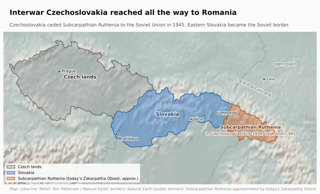
This edge matters. Beyond the Carpathians begins the open Ukrainian plain, which, as Pueyo writes, invaders from the east crossed for centuries. Eastern Slovakia is where the rim of the basin closes.
The Rusyns in the northeast are a living trace of this border to this day. In the 2021 census, 23,746 people declared Rusyn as their first ethnicity, and 63,556 including those who gave it as an additional one. That is also why East Slovak dialects are the most distinctive of all: for centuries they lived next to Rusyn and Polish.
The Highway We’ve Been Building for Half a Century
Back to the question from the beginning.
The idea is older than Slovakia itself. The first project of a “national road” from Plzeň to Košice dates from 1935, and the businessman Jan Antonín Baťa proposed his own route from Cheb through Plzeň, Brno and Žilina all the way to the Romanian border at Veľký Bočkov. In 1938, the government decided on a four-lane highway from Prague to Veľký Bočkov. In Slovakia it was to run exactly along the rim, through the chain of basins via Žilina, Liptov and Prešov. After Munich and the Vienna Award, however, on January 13, 1939, the government approved only the Prague – Jihlava – Brno – Slovak border section. Slovakia already had autonomy, and the eastern part of the original route would have run into the new border anyway: Uzhhorod and Mukachevo had just gone to Hungary. Construction began in May 1939 and stopped in 1942 for lack of money. After the war it resumed on a limited scale, but after February 1948 it was no longer a priority, and in 1950 it was stopped for good.
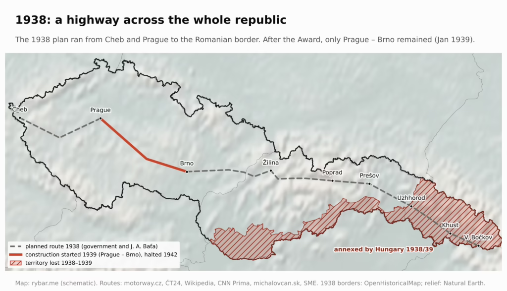
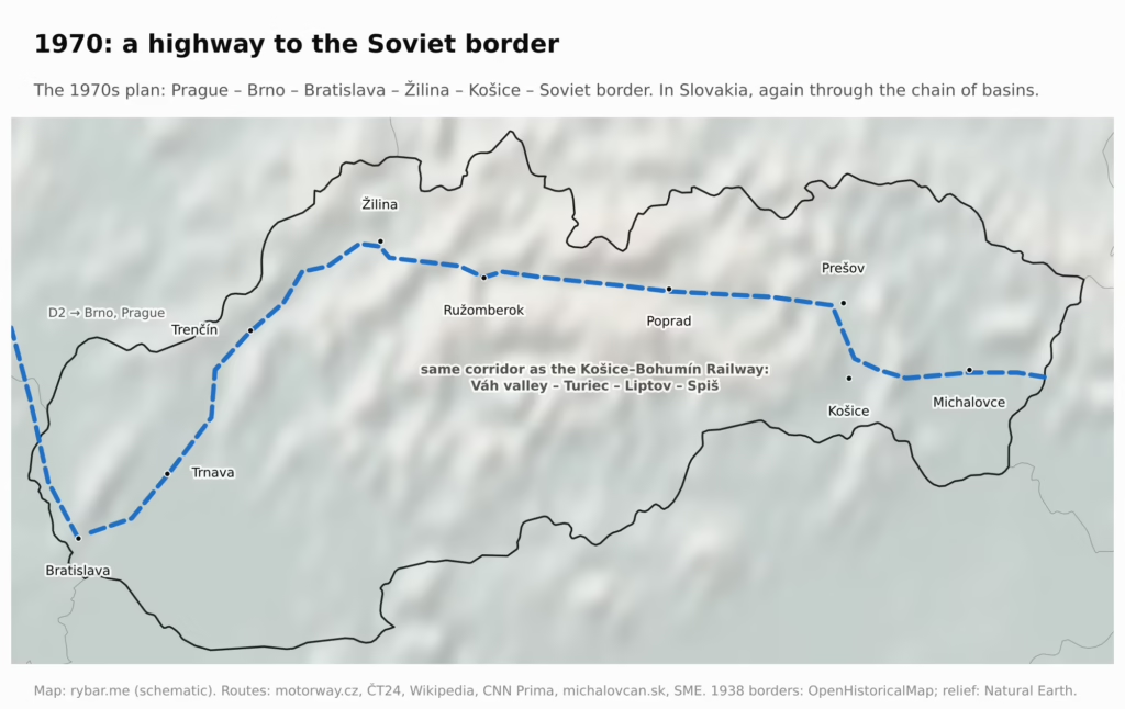
The state returned to the highway in 1963. A plan from the early 1970s envisaged a route Prague – Jihlava – Brno – Trenčín – Žilina – Prešov all the way to the Soviet border near Uzhhorod, again the same route, just without Subcarpathian Ruthenia. The first section of today’s D1, from Bratislava to Senec (then the D61 highway), was started in January 1972 and opened in December 1975. Work on the original D1 began in March 1972 near Liptovský Mikuláš, and the section to Liptovský Ján opened in December 1976. Since then, the D1 has been a favorite campaign promise. In 1998, Vladimír Mečiar opened a section near Ilava with the model Claudia Schiffer; in 2007, Robert Fico promised a finished highway to Košice by 2010.
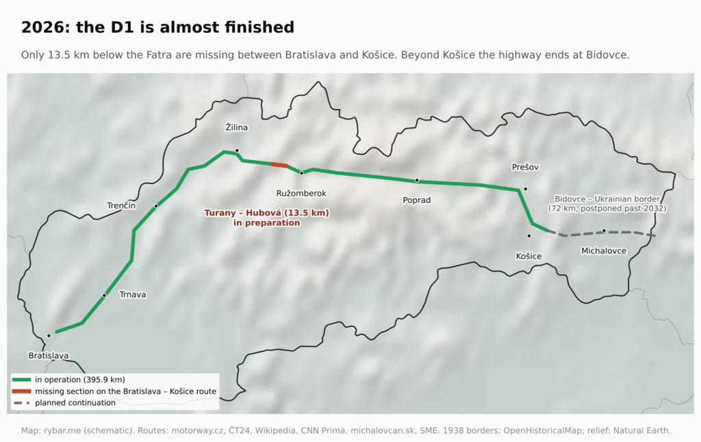
The hardest sections are where the rim folds the most: in the Váh valley between Martin and Ružomberok. The Hubová – Ivachnová section, a Ružomberok bypass with the 3.6-km Čebrať tunnel, started in 2013 and was supposed to be finished in 2017. After construction began, however, the tunnel’s route had to be changed and landslides repeatedly held up the work, so it opened only on October 5, 2026. It cost about 700 million euros.
The last piece not yet under construction, 13.5 km between Turany and Hubová with the Korbeľka and Havran tunnels, is still out to tender. The Public Procurement Office canceled the first tender from 2024; a second has been running since March 2026, and the contractor is not yet known. The estimated cost is 1.573 billion euros excluding VAT, and construction is expected to take about seven years. In October 2026, the authority issued the zoning decision for the project. A continuous highway across Slovakia will therefore come in the 2030s at the earliest. East of Košice, the D1 currently ends at Bidovce. In June 2026, amid budget cuts, the state postponed the remaining 72 km to the Ukrainian border until after 2032.
Meanwhile, in October 2021, Hungary completed the M30 highway from Miskolc to the Slovak border. Together with the M3 and M1, it created the first continuous highway between Bratislava and Košice. It runs across the plain alongside the rim, exactly where our valleys pointed for centuries.
The train is not much better, and for the same reason. Bratislava and Košice are about 310 km apart as the crow flies, but the railroad between them follows the same chain of basins as the Košice–Bohumín Railway in the 19th century: through the Váh valley, Liptov and Spiš, and below the Tatras it climbs to Štrba station at 895 meters, the highest express-train station in Slovakia. The fastest express takes 4 hours and 53 minutes from Bratislava to Košice. The record belongs to InterCity 44, with 4 hours and 31 minutes in the 2022/23 timetable. By car on the D1 through Žilina and Poprad, it takes 5 to 6 hours according to a comparison by the Startitup news site, because the highway is still unfinished. The southern route via Budapest and the M30 is about 500 km and takes roughly 5 hours.
So the fastest option is a plane. Since November 2025, Wizz Air has flown between Bratislava and Košice nine times a week, and the flight takes about an hour. The state subsidizes the route with up to 5.2 million euros through 2028. This is nothing new: the Prague – Bratislava – Košice route was the oldest Czechoslovak air connection and, with breaks, operated until 2019. Vietnam does something similar: it is another long country, with a mountain range along most of its length. Hanoi and Ho Chi Minh City are about 1,200 km apart, and with more than 11 million seats a year the route between them is one of the four busiest domestic routes in the world. Slovakia is much smaller, but the mountains between its ends make the plane the fastest way here too.
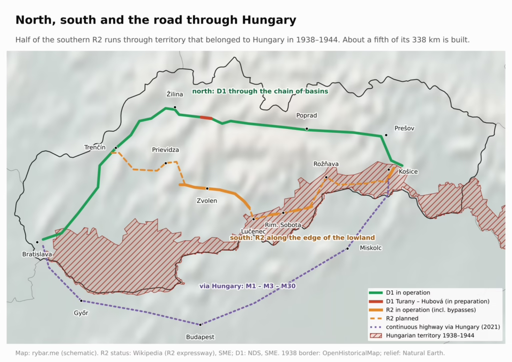
But a second axis could also run across Slovakia: along the southern edge, from Trenčín through Prievidza, Zvolen, Lučenec, Rimavská Sobota and Rožňava to Košice. This is the R2 expressway, also called the southern highway, and it follows almost the same line as the old Hungarian Gemer railroad. Until 1999, a D65 highway was planned here; then an expressway replaced it on the Zvolen – Košice section. Of the planned 338 km, about 68 km are in operation today: the Žiar nad Hronom bypass, the section from Zvolen almost to Lučenec, completed in November 2025, and a short stretch near Košice. Beyond Lučenec there are only bypasses of some villages, and the remaining sections to the east are in early preparation.
The north-versus-south dispute has gone on for decades. In the early 2000s, estimates put the southern route at 40 to 50 billion korunas and the northern one at roughly 100 billion. The Ministry of Transport defended the north on the grounds that an international transport corridor runs through it, and according to experts the dispute was always also shaped by rivalry between regions that wanted to pull the main axis toward themselves.
Geohistory adds one more argument. According to our map, roughly half of the R2 route runs through territory that Slovakia lost in 1938: Lučenec, Rimavská Sobota, Rožňava and Košice all belonged to Hungary until the end of the war. Slovak planners experienced this firsthand: the Slovak State’s highway was to run north to Prešov and from there straight through Michalovce to Sobrance, because Košice did not belong to Slovakia at the time. We did not find a document that justified the postwar choice of the northern route in exactly these terms. But the logic is the same as with the railroads: an axis deep in the mountains cannot be cut off by a single border shift, while the southern route traces a line that moved in the 20th century. The northern D1 is more expensive and slower to build, but it runs through territory Slovakia never lost.
Wealth Is Moving Out of the Mountains
The gap between a rich west and a poor east is not eternal. While wealth came from the ground, the mountains were rich. The area around Banská Štiavnica was one of the most important mining regions in the world in the 16th to 18th centuries. In 1782, Banská Štiavnica had 23,192 inhabitants and was the third-largest town in Hungary. Kremnica minted Hungarian gold ducats.
At first, 19th-century industry was also in the mountains. What mattered for ironworks were ore deposits, forests for charcoal and strong streams to drive the hammer mills, and all of that was in the Ore Mountains. At the end of the 19th century, Spiš and Gemer were the largest producers of iron ore and pig iron in the Hungarian half of the monarchy, and Gemer was called the iron heart of Hungary. But once new railroads made it possible to bring in quality coal and coke from the Austrian half of the monarchy and from Prussia, the mountains began to lose their advantage. The mining towns declined, and Banská Štiavnica has about 10,000 inhabitants today.
Even in the 20th century, heavy industry did not move to the plain. Czechoslovakia built it in the valleys and basins of northern and central Slovakia, for three reasons. The first was security. In the 1930s it moved arms production from the threatened border areas of Bohemia to the Váh valley: Czechoslovak Arms Factory (Zbrojovka) had a plant in Považská Bystrica from 1928, and Škoda launched an arms plant in Dubnica nad Váhom in 1937. In the 1950s, the center of arms production moved to Slovakia again, once more out of fear that plants in Bohemia would be attacked. The southern plain by the border, which Slovakia had partly lost in 1938, offered no such sense of security.
The second reason was raw materials. Brown coal was mined in the Upper Nitra Basin at Handlová and Nováky. In 1953 a thermal power plant started operating there, with a chemical plant next to it, and in the 1950s an aluminum smelter rose nearby in Žiar nad Hronom. The third reason was politics and supply routes. East Slovak Ironworks, which the government decided on in 1959, poured its first iron in 1965, and a year later a broad-gauge railroad from the Soviet Union was brought to it. Slovakia, mostly agricultural before the war, produced about 17.7% of Czechoslovakia’s industrial output in 1960.

After 1989 the market decided, and the market followed roads. Investment went where it is closest to customers in Germany and Austria and where the highways led. All four carmakers that produce in Slovakia are in the west and northwest: Volkswagen in Bratislava, Stellantis in Trnava, Jaguar Land Rover in Nitra and Kia near Žilina. The east is only now getting its first car plant: Volvo in Valaliky near Košice is due to start series production in early 2027.

The map shows what this meant in numbers. In 2000, the Bratislava Region’s GDP per capita in purchasing power standards was 116% of the EU average and the Prešov Region’s 31%. By 2024, Slovakia as a whole had moved from 51% to 75% of the EU average, the Bratislava Region to 153% and the Prešov Region to 46%. All regions are catching up with Europe, but the ranking hasn’t changed, and the Bratislava Region is still more than three times richer than the Prešov Region.
What It Means Today
A long, thin country with its capital in one corner has one big problem: distance from the center.
Why is the capital in the corner at all? In 1918, Bratislava was the largest city in what is now Slovakia, it lay on the Danube and had railroads to both Vienna and Budapest. From 1536 to 1783 it was the capital of Hungary, including throughout the Ottoman occupation of Buda (1541–1686). But it was not Slovak: in 1910 only 15% of its inhabitants spoke Slovak, the rest German and Hungarian. Even so, Vavro Šrobár’s government moved here from Žilina on February 4, 1919, although some Slovak patriots saw Martin as the more natural center. How a border town became a capital is the subject of another article. For this one, one thing is enough: the capital of a long country ended up at its far western end.

According to the Statistical Office of the Slovak Republic, GDP per capita in 2023 was 45,187 euros in the Bratislava Region, about 22,500 euros on average in Slovakia and 14,108 euros in the Prešov Region. Bratislava is thus more than three times richer than the Prešov Region. The Bratislava Region produced 27.2% of the country’s GDP. Only the Trnava Region (24,761 euros) is also above average; all six other regions are below it. Unemployment in 2023 was 2.9% in the Bratislava Region and 8.4% in the Prešov Region.
Bratislava is not typical Slovakia. It lies on the Danube, on a plain, on the border with two countries, and an hour from both Vienna and Budapest. Most of Slovakia, meanwhile, is a belt of mountains and basins, where towns lie in valleys and are separated from each other by ridges. Looking at Slovakia from Bratislava means looking at the mountains from the plain. That is why it’s easy to overlook in the capital how far and how expensive it is to get to Poprad, Bardejov or Snina.
People go west for work. The Prešov Region is the most populous and youngest region in Slovakia, and in 2022 it also had the lowest average wage, 1,011 euros. According to the Statistical Office, eastern Slovakia loses about 2,000 people a year to migration, mostly young and educated people. The biggest magnet is the Bratislava Region, one of the few that is growing.
Košice is not Prešov. The two cities lie on the edge of the same basin, only about 35 km apart, but in different places within it. Košice lies on the Hornád in the widest part of the Košice Basin, on the natural route from Hungary to Poland. It was the center of Upper Hungary; East Slovak Ironworks was built there in the 1960s, and today Volvo is coming. Prešov lies on the Torysa at the northern edge of the basin, and its hinterland is hilly Šariš and the border area below the Carpathians. The Košice Region has about 115 inhabitants per km² and GDP per capita of 19,800 euros (Eurostat, 2024). The Prešov Region has only 90 inhabitants per km², the second-lowest density in Slovakia, the smallest share of urban population, and GDP of 14,500 euros per capita in 2024.
The region is still an identity. Asked “where are you from?”, many people answer with a historical region: Záhorák, Kysučan, Oravec, Lipták, Šarišan, Zemplínčan. Regions separated by ridges lived independently in their counties for centuries, with their own dialects, folk costumes and food. Modern Slovakia is younger than these identities, and today’s self-governing regions often don’t match them. Local patriotism is not extra folklore; it’s a trace of geography.
National symbols came from the mountains. Jánošík, the salaš, the fujara, the valaška shepherd’s axe and bryndza halušky all come from the world of mountain shepherds, not from the world of farmers on the plain. The fertile southern plain was owned mostly by the nobility and largely inhabited by Hungarians. When the Slovak national movement of the 19th century looked for what was typically Slovak, it found it in the mountains.
Wealth moves with technology. While money was made from ore, wood and water, the mountains were rich. Railroads and imported coal took that advantage away, socialist industry still kept them going, and after 1989 wealth moved to the highways and the road west, where all the car plants stand today.
Water is wealth that flows away. Almost all Slovak water flows into Hungary, but the mountains catch it first: in the south it collects under Rye Island, and in the east in the Starina reservoir, which also supplies Košice with drinking water. The mountains that hinder our transport give us water.
Mountains protect, but they also imprison. The same mountains that were a wall for centuries and gave industry security and raw materials now make every kilometer of highway more expensive and lengthen the trip of an ambulance, a truck and an investor alike. Geography that was protection in history is an obstacle in the economy.
Not everything is geography. Politics, investment and industrial history played a role too. But geography decided how far and how expensive it is to get from one end to the other.
Answers
- Why does the first highway between Bratislava and Košice go through Hungary? Because it’s easier to build on a plain than through the Váh valleys, and because the last mountain section of the D1 is still out to tender. That’s why the fastest connection between the two cities today is a plane.
- Why is Slovakia 428 km wide but only 195 km tall? Because it is the northern rim of the Pannonian Basin, a belt of mountains and basins between the Polish and Hungarian plains. Its borders follow the ridges in the north and the plain and rivers in the south.
- Why do almost all our rivers flow south? Because the valleys run down from the ridges into the basin. Water from 96% of the country drains into the Danube.
- Why does it rain two to three times more in the Tatras than on Rye Island? Because moist air from the Atlantic drops its rain on the Alps and the Carpathians and reaches the middle of the basin already drier.
- Why were there only two decent railroads connecting us with the Czech lands in 1918? Because Hungarian railroads radiated toward Budapest rather than running west to east.
- Why do people from Záhorie and Šariš speak so differently? Because regions separated by mountains lived independently in their counties for centuries, and speech developed separately in each. Only the borders, schools and railroads of the 20th century made them one country.
- Why is the Bratislava Region more than three times richer than the Prešov Region, when the mountains were once the richest? Because the mountains’ wealth rested on ore, wood and water. Railroads and imported coal took away that advantage, and after 1989 investment went to the highways and to the west. Meanwhile, the capital lies in the far western corner of a long country, while the east is more than 400 km away by road across the mountains.
- Where did a piece of the republic in the east go? Subcarpathian Ruthenia lay beyond the mountains, its valleys led onto the Hungarian plain, and in 1945 Czechoslovakia ceded it to the Soviet Union, which wanted a common border with Hungary.
- Why were we part of Hungary for almost a thousand years? Because the rim and the basin form one whole, and whoever controlled the plain also controlled the valleys around it.
- Why are there fields in the south and shepherds’ huts in the north? Because the south is warm and flat and the north cold, wet and steep. Shepherds and their salaše were brought to the mountains by the Wallachian colonization of the 14th to 17th centuries.
- Why could the basins in the north become a refuge? Because although they are warming too, in summer they stay cooler than the south and have more water.
What’s Next
This article is the first in a series of three. The next two will answer the questions left hanging here.
Why is Bratislava on the edge? Our capital lies right on the border with two countries, and Vienna is closer to it than Banská Bystrica. How did a city that was the capital of Hungary for almost 250 years become the capital of Slovakia? And why does Petržalka, on the right bank of the Danube, belong to Slovakia at all?
Why does Slovakia exist at all? For almost a thousand years we lived in Hungary without a country of our own. Why didn’t Upper Hungary become part of Hungary, Poland or the Czech lands? And what changed in 1918, 1939 and 1993? We will also show how the mountains served as a wall for centuries, against the Ottomans and in 1944, and why their trace is still visible in election maps today.
For both questions, the same holds as for this one: a map explains more than you would expect.
Sources
Most sources are in Slovak.
- Tomas Pueyo – Why Is Hungary So Small? (Uncharted Territories, 2024)
- Dimensions: IAEA – Slovakia country profile; Wikipedia – Extreme points of Slovakia
- Borders: MV SR – Štátne hranice SR (2018)
- Lowlands 28.4%: Basovský a kol. 1982, Geografický časopis SAV
- 96% Danube basin: UPJŠ Košice; Poprad a Dunajec: Wikipedia – Poprad, Dunajec; Podtatranská kotlina
- Rivers: Wikipedia – List of rivers of Slovakia; Ipeľ
- Košice: Wikipedia – Košice
- Railroads: Discussion Papers RKK – Transport in the Carpathians; Wikipedia – Košice–Bohumín Railway; Bohemia – Building a Railway Network in Interwar Czechoslovakia; Poslanecká snemovňa – Červená Skala–Margecany 1936; Studia UBB – cesty po 1918
- Subcarpathian Ruthenia 1945: Encyclopedia of Ukraine; Radio Prague; FRUS 1945 – telegram o dôvodoch odstúpenia; Chust 1938
- Hungarians in Slovakia: Sčítanie 2021, TASR; Noviny.sk – národnosti 2021; Filadelfi 2012, Klaudyán
- Population exchange and re-Slovakization: ÚPN – Výmena obyvateľstva; Fórum Társadalomtudományi Szemle 2009
- Vienna Award and railroads: TASR – 85 rokov od arbitráže; ÚPN – Mníchov pre Slovensko; Rail.sk – Vídeňská arbitráž a železnice; TASR – trať Prešov – Humenné
- History of the D1: SITA – výstavba diaľnic trvá 50 rokov, D61 Bratislava – Senec a Liptovský Mikuláš – Liptovský Ján; Forbes – O D1 snívame 84 rokov; Pravda – Nekonečný príbeh jednej autostrády; SME – Dokončenie D1 sľubovali Mečiar i Fico; SME Liptov – 15 otázok o obchvate Ružomberka
- Bratislava as capital: Habsburger.net – Pressburg; Wikipedia – Bratislava; ÚVZ SR – Vavro Šrobár
- Rusyns 2021: SITA; Rusyn Society
- Dialects: Slovake.eu
- D1: Slovak Spectator – 51 rokov výstavby; TASR – otvorenie Hubová–Ivachnová; CDB; Zoznam – náklady; TASR – tender Turany–Hubová; TASR – 7 rokov prác
- M30: Slovak Spectator; Wikipedia – M30
- D1 tender status: SME Index – Tender na posledný úsek D1 sa opäť odkladá; doprava.org – Súd nepozastavil spor o D1 Turany – Hubová
- Railroads in 1918: Slovácko 2004, Slovácké muzeum; Národné zhromaždenie, 26. 6. 1919; Považská železnica 1883: TASR
- Trains: SITA – grafikon 2025/26; SITA – IC 44 rekord
- GDP and unemployment: ŠÚ SR – Charakteristika regiónu, všetkých 8 krajov (údaje 2023); ISA – Ekonomický prehľad
- Slovakia’s borders in 1918: TASR – historik Dušan Kováč; SITA – vznik ČSR a slovenská identita
- Dialects: TASR – K. Balleková, asi 25 nárečí; TASR – M. Smatana o nárečiach; Múcsková G. – Slovak Dialect Classifications; Buffa F., Slovenská reč 1986; Slovake.eu – nárečia; Wikipedia – Eastern Slovak dialects; Wikipedia – History of the Slovak language; Maxwell A., Prečo má slovenčina tri nárečia, Forum Historiae
- Codification of Slovak: TASR – Anton Bernolák; TASR – štúrovci 1843
- Colonizations: Molnárová – Nemci v Hauerlande, Etnologické rozpravy 2023; Valašská kolonizácia, Archaeologia historica 1988; Janto – kolonizácia na valašskom práve; TASR – Chorváti na Slovensku
- Languages in 1910 and Bratislava: Sebők – Gyurgyík (pozri vyššie); Wikipedia – Germans in Czechoslovakia)
- Jews and Germans: JewishGen – sčítanie 1930; SITA – holokaust, historik I. Kamenec; Geographia Cassoviensis – Nemci na východnom Slovensku
- Language maps 1910 and 2021: Sebők L. – Gyurgyík L., Národnostná databáza Slovenska 1870–2021, Kisebbségkutató Intézet; ŠÚ SR – SODB 2021, materinský jazyk 8,5 %; Zudel J., Sčítanie 1910 a maďarizácia, Geografický časopis 1994; poloha obcí: michalskop/SK-municipalities-geocoded
- Vienna Award border on the maps: OpenHistoricalMap – Magyar Királyság 1938–1939, licencia CC0
- Interwar railroads: Národné zhromaždenie, správy o stavbe Handlová – Horná Štubňa a Červená Skala – Margecany; TASR – trať Zvolen – Horná Štubňa a priečna os; rail.sk – Železnice po arbitráži
- Subcarpathian Ruthenia: geography: Rozloha a sčítanie 1930, Národní muzeum; rieky: Studi Ungheresi; železnice v dolnách: Hungarian Geographical Bulletin; trať cez Rumunsko: Zakarpattia tourism; hranica podľa železníc: Rubicon
- Southern R2 route: Wikipedia – R2 expressway); Wikipédia – Rýchlostná cesta R2, D65 a rok 1999); SME – otvorenie R2 pri Lučenci; Profini – Sever proti juhu; Denník N – Prvú diaľnicu cez Slovensko nakreslili pred 80 rokmi; Wikipédia – Dejiny výstavby diaľnic na Slovensku, plán Slovenského štátu; podêl trasy R2 na území arbitráže: vlastný výpočet z mapy
- Highway plans 1935–1970: ČT24 – Déjednička sláví, zastavenie 1950; ČT24 – D1 najstaršia diaľnica; E15 – Baťova trasa; motorway.cz – história; Wikipedia – D1 (Česko)); CNN Prima – plán do ZSSR
- D1 today: SME Index – rozhodnutie o umiestnení Turany – Hubóvá; Michalovcan – D1 na Zemplín
- Air circulation: Sitányiová D. – Klimatické pomery SR, UNIZA; Krnáč J. – Tatry a severozápadné prúdenie, Geografický časopis 1979
- Climate: WorldClim 2.1 – Fick, S. E. & Hijmans, R. J. (2017), International Journal of Climatology
- Rye Island: SITA – SAV o podzemných vodách; Starina: SVP
- Wallachian colonization and bryndza: Janto, J. – Muzeológia a kultúrne dedičstvo 2017; Janto 2016 – Salašný chov oviec
- Density and altitude of municipalities: vlastný výpočet zo sčítania 2021 (Sebők – Gyurgyík) a výškových dát Mapzen; Prešovský kraj: ŠÚ SR – Charakteristika kraja
- Mining towns: slovensko.sk – Banská Štiavnica; Wikipedia – Banská Štiavnica
- Volvo Košice: TASR
- Migration and wages: SITA – vyľudňovanie východu; Hodnotiaca správa NRO – mzdy v krajoch
- 2023 election: Noviny.sk – výsledky podľa okresov; Startitup – výsledky podľa krajov
- Extreme temperatures and warming: SHMÚ cez Startitup – hodnotenie leta 2026; Noviny.sk – rekord 42,2 °C; Slovak Spectator – stanica Hurbanovo; Noviny.sk – hranica 27 °C podľa SHMÚ
- Košice Region: Košický samosprávny kraj – PHSR; HDP krajov 2000 – 2024: Eurostat nama_10r_3gdp
- Arms factories in the Váh valley: VHÚ – Zbrojársky priemysel na Slovensku v 30. rokoch; VHÚ – Vojenská história, 50. roky; TASR – Dubnica
- Industrialization and East Slovak Ironworks: Košír – Geografický časopis 1960; Gorka – Architektúra & urbanizmus 2021
- Economic history: Patera – Historický časopis 2022, železiarstvo v spišsko-gemerskej oblasti; Patera – Česko-slovenská historická ročenka 2024; MV SR – Rimamuránska spoločnosť, Železník
- 20th-century industry: Náučný banský chodník Nováky; Slovak Spectator – Žiar nad Hronom; TASR – 60 rokov VSŽ; Wikipedia – širokorozchodná trať
- Bratislava–Košice flights: Noviny.sk – Wizz Air spustil linku; TASR – dotácia 5,2 mil. eur; TASR – linka ČSA Praha – Bratislava – Košice do roku 2019
- Vietnam: Tuoi Tre – Hanoj – Hočiminovo Mesto 4. najvyťaženejšia domáca linka 2025 podľa OAG
- Driving times: Startitup – porovnanie ciest Bratislava – Košice
- Drought and growing season: Startitup – sucho na Žitnom ostrove; Mesto Trnava – klimatické zmeny, SHMÚ a FMFI UK
Maps and Chart
All maps and the chart are our own (rybar.me). 3D relief and the map of Subcarpathian Ruthenia: elevation data Mapzen / AWS Terrain Tiles. 1938 borders: OpenHistoricalMap (CC0). Language maps: Sebők – Gyurgyík database. Relief: Tom Patterson / Natural Earth; borders and rivers: Natural Earth (public domain); chart data: Statistical Office of the Slovak Republic. The maps are simplified and the border of Hungary is approximate. Climate maps: WorldClim 2.1 (CC BY 4.0); the economic map is schematic.